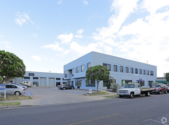
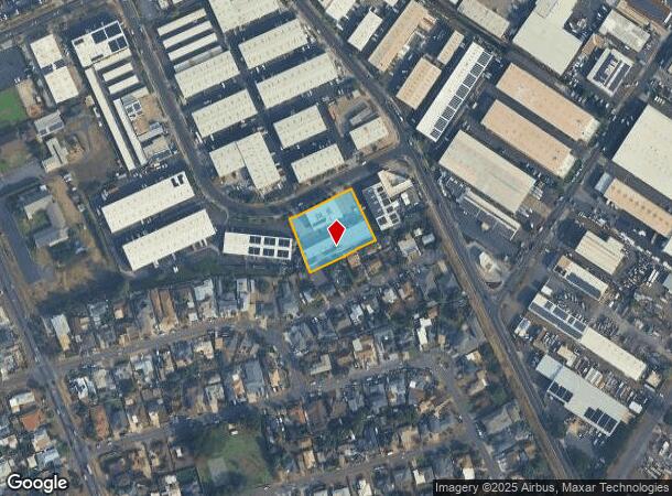
Property Record
360 Hoohana St, Kahului, HI 96732
NEARBY LISTINGS FOR SALE OR LEASE
Property Detail
360 Hoohana St
Kahului-Wailuku-Lahaina, HI
Maui Industrial Park
2-3-8-066-046-0000
LOT 11-A MAUI INDUSTRIAL PARK NO 3 POR OF RP 3343 44,272 SF DES
Industrialgeneral
Maui
X
Hawaii
1500030392E
11-a
2024
1.02 AC
2025
Central Maui
031900
Hawaii
26,942 SF
DEMOGRAPHICS near 360 Hoohana St
1 Mile
3 Mile
5 Mile
2024 Total Population
8,903
40,882
54,333
2029 Population
8,598
39,936
53,303
Pop Growth 2024-2029
(3.43%)
(2.31%)
(1.90%)
Average Age
41
40
40
2024 Total Households
2,257
11,674
15,726
HH Growth 2024-2029
(4.16%)
(2.99%)
(2.52%)
Median Household Inc
$72,856
$72,163
$81,126
Avg Household Size
3.40
3.20
3.20
2024 Avg HH Vehicles
2.00
2.00
2.00
Median Home Value
$707,865
$661,101
$673,312
Median Year Built
1972
1981
1986
Nearby Places
Map Layers
Map Styles
 Street
 Aerial
- Restaurants
- Banks
- Shops
- Fitness
- Groceries
PUBLIC TRANSPORTATION
AIRPORT
Kahului
DRIVE
WALK
Distance
Kahului
11 min
4.4 mi
SALE & LEASE HISTORY
LISTING DATE
SALE/LEASE

Sep 25, 2025
For Lease
Sep 25, 2016
For Lease
Nov 15, 2024
For Lease
Apr 09, 2023
For Lease
Nearby Properties
Address
Land Use
TOTAL SIZE
Lot Size
Zoning
Address
Land Use
TOTAL SIZE
Lot Size
Zoning
14.34 AC
500
Address
Land Use
TOTAL SIZE
Lot Size
Zoning
191,252 SF
25.37 AC
420
Address
Land Use
TOTAL SIZE
Lot Size
Zoning
141,663 SF
11.88 AC
Address
Land Use
TOTAL SIZE
Lot Size
Zoning
43,434 SF
13.89 AC
410
Address
Land Use
TOTAL SIZE
Lot Size
Zoning
130,920 SF
11.42 AC
Address
Land Use
TOTAL SIZE
Lot Size
Zoning
153,273 SF
10.95 AC
Address
Land Use
TOTAL SIZE
Lot Size
Zoning
149,380 SF
12.84 AC
420
Address
Land Use
TOTAL SIZE
Lot Size
Zoning
144,519 SF
12.99 AC
410
Address
Land Use
TOTAL SIZE
Lot Size
Zoning
103,221 SF
12.93 AC
720
Address
Land Use
TOTAL SIZE
Lot Size
Zoning
234,826 SF
14.36 AC
410
Address
Land Use
TOTAL SIZE
Lot Size
Zoning
25,358 SF
9.88 AC
Address
Land Use
TOTAL SIZE
Lot Size
Zoning
4.10 AC
410
Address
Land Use
TOTAL SIZE
Lot Size
Zoning
56,906 SF
8.69 AC
410
Address
Land Use
TOTAL SIZE
Lot Size
Zoning
79,284 SF
3.35 AC
215
Address
Land Use
TOTAL SIZE
Lot Size
Zoning
94,821 SF
7.30 AC
420
Address
Land Use
TOTAL SIZE
Lot Size
Zoning
5.11 AC
Address
Land Use
TOTAL SIZE
Lot Size
Zoning
19.54 AC
720
Address
Land Use
TOTAL SIZE
Lot Size
Zoning
72,457 SF
2.96 AC
320
Address
Land Use
TOTAL SIZE
Lot Size
Zoning
24,848 SF
11.41 AC
500
Address
Land Use
TOTAL SIZE
Lot Size
Zoning
552,589 SF
24.60 AC
420
Address
Land Use
TOTAL SIZE
Lot Size
Zoning
81,702 SF
4.40 AC
Address
Land Use
TOTAL SIZE
Lot Size
Zoning
72,377 SF
6.06 AC
720
Address
Land Use
TOTAL SIZE
Lot Size
Zoning
53,684 SF
119.45 AC
Address
Land Use
TOTAL SIZE
Lot Size
Zoning
1.83 AC
Address
Land Use
TOTAL SIZE
Lot Size
Zoning
16.75 AC
320
Address
Land Use
TOTAL SIZE
Lot Size
Zoning
12.49 AC
Address
Land Use
TOTAL SIZE
Lot Size
Zoning
94,025 SF
0.84 AC
370
Address
Land Use
TOTAL SIZE
Lot Size
Zoning
69,340 SF
5.33 AC
320
Address
Land Use
TOTAL SIZE
Lot Size
Zoning
103,520 SF
4.50 AC
720
Address
Land Use
TOTAL SIZE
Lot Size
Zoning
2.01 AC
The World's #1 Commercial Real Estate Marketplace
Connect with us
© 2025 CoStar Group
The information above has been obtained from sources believed reliable. While we do not doubt its accuracy we have not verified it and make no guarantee, warranty or representation about it. It is your responsibility to independently confirm its accuracy and completeness. Any projections, opinions, assumptions, or estimates used are for example only and do not represent the current or future performance of the property. The value of this transaction to you depends on tax and other factors which should be evaluated by your tax, financial, and legal advisors. You and your advisors should conduct a careful, independent investigation of the property to determine to your satisfaction the suitability of the property for your needs.