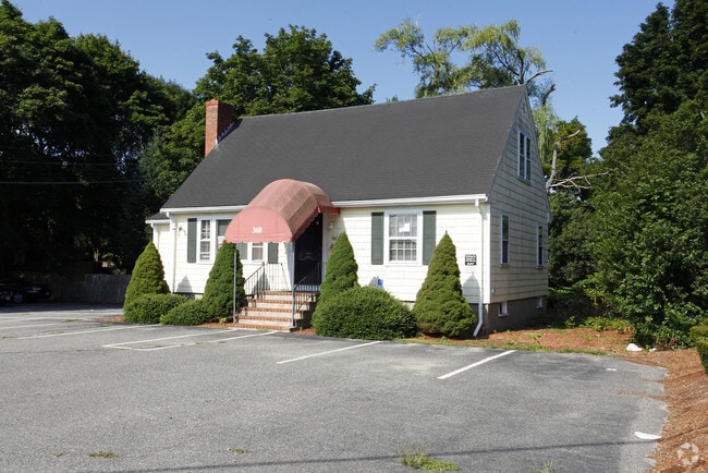
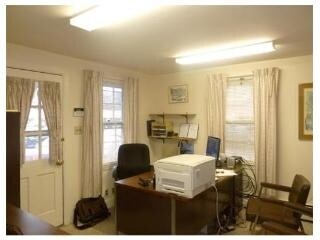
Property Record
360 Main St, Dunstable, MA 01827

Property Detail
360 Main St
Boston-Cambridge-Newton, MA-NH
MIDDLESEX
DUNS-000017-000143-000004
Massachusetts
Governmentalpublicusegeneral
60
B and X Area of moderate flood hazard, usually the area between the limits of the 100-year and 500-year floods.
2.09 AC
2025
Wilmington/Reading
2025
Boston
315100
NEARBY LISTINGS FOR SALE OR LEASE
DEMOGRAPHICS near 360 Main St
1 mile
3 mile
5 mile
2025 Total Population
14,482
79,598
205,288
2030 Population
15,076
82,560
212,595
Pop Growth 2025-2030
+ 4.10%
+ 3.72%
+ 3.56%
Average Age
42
43
42
2025 Total Households
5,586
31,441
79,704
HH Growth 2025-2030
+ 4.26%
+ 3.86%
+ 3.71%
Median Household Inc
$142,633
$127,744
$130,305
Avg Household Size
2.50
2.50
2.50
2025 Avg HH Vehicles
2.00
2.00
2.00
Median Home Value
$757,309
$752,833
$761,285
Median Year Built
1955
1961
1963
Nearby Places
Map Layers
Map Styles
 Street
 Aerial
Transit
 Traffic
 Biking
Places
Listings with unknown addresses are not visible on the map
- Restaurants
- Banks
- Shops
- Fitness
- Groceries
PUBLIC TRANSPORTATION
AIRPORT
Manchester Boston Regional
Drive
Walk
Distance
Manchester Boston Regional
36 min
23.6 mi
Freight Ports
Port of Boston
Drive
Walk
Distance
Port of Boston
60 min
43.4 mi
Nearby Properties
Address
Land Use
TOTAL SIZE
Lot Size
Zoning
Address
Land Use
TOTAL SIZE
Lot Size
Zoning
38.17 AC
RC
Address
Land Use
TOTAL SIZE
Lot Size
Zoning
29.77 AC
RC
Address
Land Use
TOTAL SIZE
Lot Size
Zoning
80.11 AC
PI
Address
Land Use
TOTAL SIZE
Lot Size
Zoning
118.50 AC
PI
Address
Land Use
TOTAL SIZE
Lot Size
Zoning
303,508 SF
171.19 AC
G1
Address
Land Use
TOTAL SIZE
Lot Size
Zoning
52.45 AC
R18
Address
Land Use
TOTAL SIZE
Lot Size
Zoning
206,913 SF
18.30 AC
GB
Address
Land Use
TOTAL SIZE
Lot Size
Zoning
15.16 AC
GI
Address
Land Use
TOTAL SIZE
Lot Size
Zoning
153,922 SF
6.84 AC
GB
Address
Land Use
TOTAL SIZE
Lot Size
Zoning
127,494 SF
9.09 AC
GB
Address
Land Use
TOTAL SIZE
Lot Size
Zoning
199.97 AC
B2
Address
Land Use
TOTAL SIZE
Lot Size
Zoning
21.17 AC
RC
Address
Land Use
TOTAL SIZE
Lot Size
Zoning
8.09 AC
RC
Address
Land Use
TOTAL SIZE
Lot Size
Zoning
154,620 SF
8.63 AC
GB
Address
Land Use
TOTAL SIZE
Lot Size
Zoning
12.57 AC
RC
Address
Land Use
TOTAL SIZE
Lot Size
Zoning
233,668 SF
16.83 AC
PI
Address
Land Use
TOTAL SIZE
Lot Size
Zoning
144,018 SF
13.89 AC
PI
Address
Land Use
TOTAL SIZE
Lot Size
Zoning
161,790 SF
9 AC
PI
Address
Land Use
TOTAL SIZE
Lot Size
Zoning
8.30 AC
B3
Address
Land Use
TOTAL SIZE
Lot Size
Zoning
135,324 SF
70.07 AC
R1
Address
Land Use
TOTAL SIZE
Lot Size
Zoning
90,463 SF
8.56 AC
RA
Address
Land Use
TOTAL SIZE
Lot Size
Zoning
120,888 SF
11.78 AC
HB
Address
Land Use
TOTAL SIZE
Lot Size
Zoning
7.21 AC
RC
Address
Land Use
TOTAL SIZE
Lot Size
Zoning
80,021 SF
4.55 AC
PI
Address
Land Use
TOTAL SIZE
Lot Size
Zoning
56,460 SF
5.81 AC
GB
Address
Land Use
TOTAL SIZE
Lot Size
Zoning
95,040 SF
7.33 AC
RC
Address
Land Use
TOTAL SIZE
Lot Size
Zoning
101,464 SF
8.52 AC
GB
Address
Land Use
TOTAL SIZE
Lot Size
Zoning
149,960 SF
7.85 AC
GB
Address
Land Use
TOTAL SIZE
Lot Size
Zoning
146,536 SF
7.45 AC
GB
The World's #1 Commercial Real Estate Marketplace
Connect with us
© 2026 CoStar Group
The information above has been obtained from sources believed reliable. While we do not doubt its accuracy we have not verified it and make no guarantee, warranty or representation about it. It is your responsibility to independently confirm its accuracy and completeness. Any projections, opinions, assumptions, or estimates used are for example only and do not represent the current or future performance of the property. The value of this transaction to you depends on tax and other factors which should be evaluated by your tax, financial, and legal advisors. You and your advisors should conduct a careful, independent investigation of the property to determine to your satisfaction the suitability of the property for your needs.