Property Record
360 Route 101, Bedford, NH 03110
NEARBY LISTINGS FOR SALE OR LEASE
Property Detail
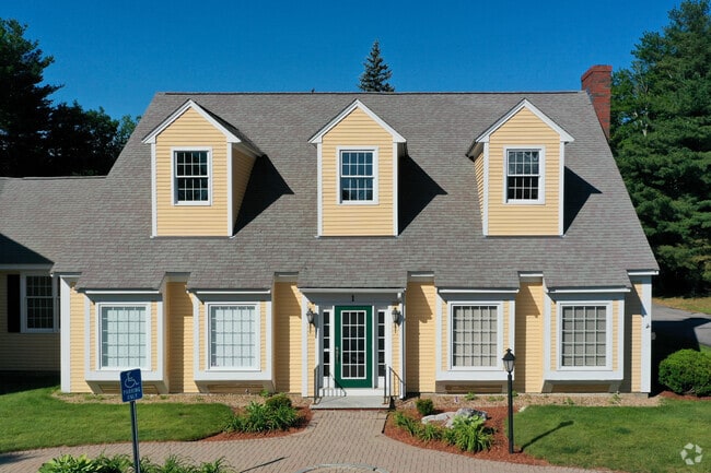
360 Route 101
Officecondo
Hillsborough
X
New Hampshire
33011C0366D
3-8
2024
Hillsborough
2024
Boston
002903
Manchester-Nashua, NH
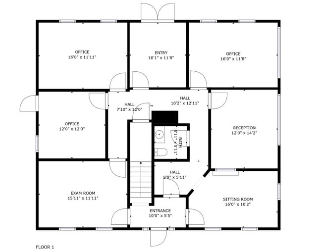
3,848 SF
BEDD-000031-000001-000003-000008
DEMOGRAPHICS near 360 Route 101
1 Mile
3 Mile
5 Mile
2024 Total Population
1,981
18,028
59,584
2029 Population
2,020
18,445
61,043
Pop Growth 2024-2029
+ 1.97%
+ 2.31%
+ 2.45%
Average Age
41
41
42
2024 Total Households
643
5,930
21,813
HH Growth 2024-2029
+ 1.87%
+ 2.31%
+ 2.49%
Median Household Inc
$172,596
$159,012
$113,903
Avg Household Size
3.10
3.00
2.60
2024 Avg HH Vehicles
2.00
2.00
2.00
Median Home Value
$623,786
$534,463
$406,221
Median Year Built
1987
1986
1983
Nearby Places
Map Layers
Map Styles
 Street
 Aerial
- Restaurants
- Banks
- Shops
- Fitness
- Groceries
PUBLIC TRANSPORTATION
AIRPORT
Manchester Boston Regional
DRIVE
WALK
Distance
Manchester Boston Regional
19 min
8.9 mi
Freight Ports
Port of Boston
DRIVE
WALK
Distance
Port of Boston
88 min
62.6 mi
SALE & LEASE HISTORY
LISTING DATE
SALE/LEASE

Sep 16, 2022
For Lease
Oct 17, 2023
For Sale
Oct 04, 2022
For Lease
Nov 01, 2023
For Lease
May 07, 2024
For Sale
Mar 01, 2023
For Lease
Dec 08, 2023
For Sale
Aug 30, 2023
For Lease
Aug 12, 2022
For Sale
Aug 02, 2022
For Lease
Nearby Properties
Address
Land Use
TOTAL SIZE
Lot Size
Zoning
Address
Land Use
TOTAL SIZE
Lot Size
Zoning
347,230 SF
42.11 AC
RA
Address
Land Use
TOTAL SIZE
Lot Size
Zoning
Address
Land Use
TOTAL SIZE
Lot Size
Zoning
97,267 SF
9.09 AC
OF
Address
Land Use
TOTAL SIZE
Lot Size
Zoning
114,808 SF
47.40 AC
RA
Address
Land Use
TOTAL SIZE
Lot Size
Zoning
49,133 SF
3.95 AC
CO
Address
Land Use
TOTAL SIZE
Lot Size
Zoning
137,515 SF
IN
Address
Land Use
TOTAL SIZE
Lot Size
Zoning
39,504 SF
2.52 AC
Address
Land Use
TOTAL SIZE
Lot Size
Zoning
43,618 SF
OF
Address
Land Use
TOTAL SIZE
Lot Size
Zoning
16,404 SF
5.01 AC
CO
Address
Land Use
TOTAL SIZE
Lot Size
Zoning
18,204 SF
55.70 AC
RA
Address
Land Use
TOTAL SIZE
Lot Size
Zoning
35,752 SF
6.47 AC
CO
Address
Land Use
TOTAL SIZE
Lot Size
Zoning
0.51 AC
CO
Address
Land Use
TOTAL SIZE
Lot Size
Zoning
26,595 SF
11.70 AC
CO
Address
Land Use
TOTAL SIZE
Lot Size
Zoning
24,017 SF
9.16 AC
RA
Address
Land Use
TOTAL SIZE
Lot Size
Zoning
31,362 SF
3.60 AC
OF
Address
Land Use
TOTAL SIZE
Lot Size
Zoning
9,631 SF
11.25 AC
RR
Address
Land Use
TOTAL SIZE
Lot Size
Zoning
14,011 SF
10.01 AC
CO
Address
Land Use
TOTAL SIZE
Lot Size
Zoning
12,419 SF
61.26 AC
RA
Address
Land Use
TOTAL SIZE
Lot Size
Zoning
2,692 SF
123.80 AC
RA
Address
Land Use
TOTAL SIZE
Lot Size
Zoning
17,655 SF
Address
Land Use
TOTAL SIZE
Lot Size
Zoning
13,126 SF
138.60 AC
RESIDE
Address
Land Use
TOTAL SIZE
Lot Size
Zoning
13,682 SF
1.40 AC
CO
Address
Land Use
TOTAL SIZE
Lot Size
Zoning
11,726 SF
4.31 AC
CO
Address
Land Use
TOTAL SIZE
Lot Size
Zoning
17,534 SF
2.11 AC
RA
Address
Land Use
TOTAL SIZE
Lot Size
Zoning
3,000 SF
29.57 AC
RA
Address
Land Use
TOTAL SIZE
Lot Size
Zoning
17.28 AC
RA
Address
Land Use
TOTAL SIZE
Lot Size
Zoning
Address
Land Use
TOTAL SIZE
Lot Size
Zoning
14,082 SF
1.94 AC
OF
Address
Land Use
TOTAL SIZE
Lot Size
Zoning
7,824 SF
37.34 AC
RR
Address
Land Use
TOTAL SIZE
Lot Size
Zoning
19,835 SF
14.80 AC
NT
The World's #1 Commercial Real Estate Marketplace
Connect with us
© 2025 CoStar Group
The information above has been obtained from sources believed reliable. While we do not doubt its accuracy we have not verified it and make no guarantee, warranty or representation about it. It is your responsibility to independently confirm its accuracy and completeness. Any projections, opinions, assumptions, or estimates used are for example only and do not represent the current or future performance of the property. The value of this transaction to you depends on tax and other factors which should be evaluated by your tax, financial, and legal advisors. You and your advisors should conduct a careful, independent investigation of the property to determine to your satisfaction the suitability of the property for your needs.