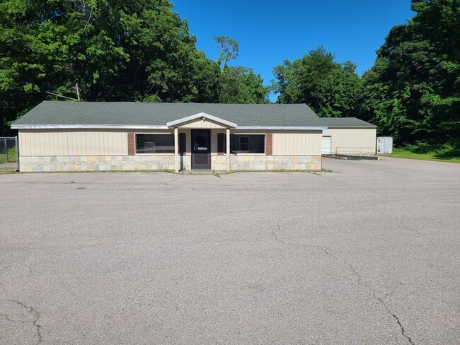
Property Record
360 S 3Rd Ave, Fruitport, MI 49415
NEARBY LISTINGS FOR SALE OR LEASE
Property Detail
360 S 3Rd Ave
Muskegon, MI
Village Of Fruitport
41-136-400-0022-00
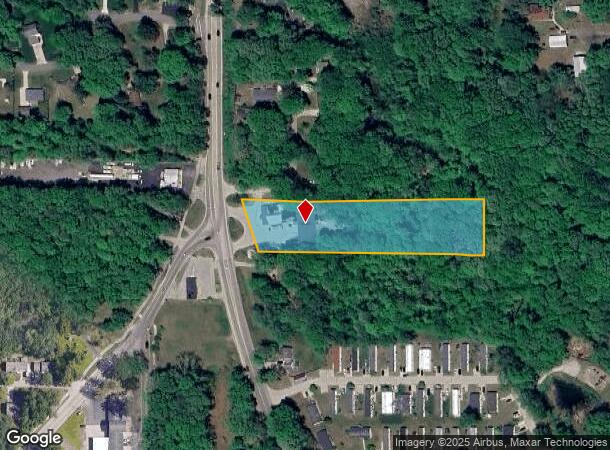
VILLAGE OF FRUITPORT SEC 36 T9N R16W S 174 FT OF THAT PART OF GOVT LOT 3 LYING S OF NORRIS CRK & E OF HWY EXC E 330 FT 2.61
Commercialnec
Muskegon
X
Michigan
26121C0407E
3
2024
2.64 AC
2025
Grand Haven/Ferrysburg
002800
West Michigan
9,420 SF
DEMOGRAPHICS near 360 S 3Rd Ave
1 Mile
3 Mile
5 Mile
2024 Total Population
2,698
15,398
42,048
2029 Population
2,773
16,065
43,715
Pop Growth 2024-2029
+ 2.78%
+ 4.33%
+ 3.96%
Average Age
41
42
42
2024 Total Households
1,058
6,110
17,140
HH Growth 2024-2029
+ 2.93%
+ 4.50%
+ 4.12%
Median Household Inc
$87,204
$72,483
$71,241
Avg Household Size
2.50
2.50
2.40
2024 Avg HH Vehicles
2.00
2.00
2.00
Median Home Value
$244,670
$271,206
$255,745
Median Year Built
1976
1989
1983
Nearby Places
Map Layers
Map Styles
 Street
 Aerial
- Restaurants
- Banks
- Shops
- Fitness
- Groceries
SALE & LEASE HISTORY
LISTING DATE
SALE/LEASE

Jun 06, 2024
For Sale
Nearby Properties
Address
Land Use
TOTAL SIZE
Lot Size
Zoning
Address
Land Use
TOTAL SIZE
Lot Size
Zoning
381,476 SF
17.96 AC
I INDU
Address
Land Use
TOTAL SIZE
Lot Size
Zoning
273,059 SF
30.59 AC
PUD
Address
Land Use
TOTAL SIZE
Lot Size
Zoning
40,251 SF
159.38 AC
PR
Address
Land Use
TOTAL SIZE
Lot Size
Zoning
207,571 SF
22 AC
LI
Address
Land Use
TOTAL SIZE
Lot Size
Zoning
55,600 SF
LI
Address
Land Use
TOTAL SIZE
Lot Size
Zoning
2,724 SF
56.50 AC
MHP
Address
Land Use
TOTAL SIZE
Lot Size
Zoning
64,143 SF
11.43 AC
LI
Address
Land Use
TOTAL SIZE
Lot Size
Zoning
118,532 SF
8.16 AC
REC
Address
Land Use
TOTAL SIZE
Lot Size
Zoning
81,894 SF
8.60 AC
I INDU
Address
Land Use
TOTAL SIZE
Lot Size
Zoning
74,151 SF
6.03 AC
I INDU
Address
Land Use
TOTAL SIZE
Lot Size
Zoning
588 SF
39.91 AC
MHP
Address
Land Use
TOTAL SIZE
Lot Size
Zoning
4,064 SF
39.10 AC
Address
Land Use
TOTAL SIZE
Lot Size
Zoning
2,618 SF
13.25 AC
LI
Address
Land Use
TOTAL SIZE
Lot Size
Zoning
32,368 SF
Address
Land Use
TOTAL SIZE
Lot Size
Zoning
141,122 SF
9.67 AC
I INDU
Address
Land Use
TOTAL SIZE
Lot Size
Zoning
88,970 SF
6.46 AC
PUD
Address
Land Use
TOTAL SIZE
Lot Size
Zoning
25,250 SF
2.81 AC
PUD
Address
Land Use
TOTAL SIZE
Lot Size
Zoning
38,563 SF
B-3
Address
Land Use
TOTAL SIZE
Lot Size
Zoning
71,360 SF
8.27 AC
B-3
Address
Land Use
TOTAL SIZE
Lot Size
Zoning
60,762 SF
4.61 AC
PUD
Address
Land Use
TOTAL SIZE
Lot Size
Zoning
13 AC
MHP
Address
Land Use
TOTAL SIZE
Lot Size
Zoning
95,126 SF
5.08 AC
LI
Address
Land Use
TOTAL SIZE
Lot Size
Zoning
32,797 SF
B-3
Address
Land Use
TOTAL SIZE
Lot Size
Zoning
103,604 SF
14.65 AC
GI
Address
Land Use
TOTAL SIZE
Lot Size
Zoning
16,290 SF
16.74 AC
R-6
Address
Land Use
TOTAL SIZE
Lot Size
Zoning
27,768 SF
4.58 AC
GC
Address
Land Use
TOTAL SIZE
Lot Size
Zoning
75,791 SF
5.58 AC
GI
Address
Land Use
TOTAL SIZE
Lot Size
Zoning
12,518 SF
4.76 AC
PUD
Address
Land Use
TOTAL SIZE
Lot Size
Zoning
122,963 SF
4.23 AC
LI
Address
Land Use
TOTAL SIZE
Lot Size
Zoning
1,416 SF
78 AC
PURD
The World's #1 Commercial Real Estate Marketplace
Connect with us
© 2025 CoStar Group
The information above has been obtained from sources believed reliable. While we do not doubt its accuracy we have not verified it and make no guarantee, warranty or representation about it. It is your responsibility to independently confirm its accuracy and completeness. Any projections, opinions, assumptions, or estimates used are for example only and do not represent the current or future performance of the property. The value of this transaction to you depends on tax and other factors which should be evaluated by your tax, financial, and legal advisors. You and your advisors should conduct a careful, independent investigation of the property to determine to your satisfaction the suitability of the property for your needs.