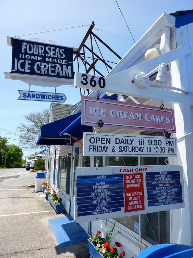
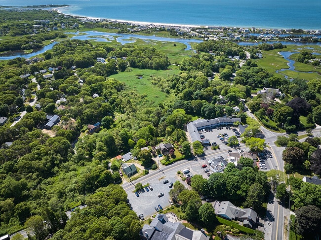
Property Record
360 S Main St, Centerville, MA 02632

Save to a Folder
{{folder.Name}}
{{folder.ListingIds.length}} Properties
{{folder.ListingIds.length}} Property
Create a New Folder
Property Detail
360 S Main St
CENT-000207-000000-000059
Barnstable
Commercialbuilding
Massachusetts
B
59
B and X Area of moderate flood hazard, usually the area between the limits of the 100-year and 500-year floods.
0.43 AC
2025
Cape Cod
2025
Other Market Areas
012700
Barnstable Town, MA
1,475 SF
NEARBY LISTINGS FOR SALE OR LEASE
DEMOGRAPHICS near 360 S Main St
1 mile
3 mile
5 mile
2025 Total Population
2,973
26,710
42,800
2030 Population
2,994
26,396
42,194
Pop Growth 2025-2030
+ 0.71%
(1.18%)
(1.42%)
Average Age
51
47
47
2025 Total Households
1,314
11,160
18,008
HH Growth 2025-2030
+ 0.46%
(1.24%)
(1.52%)
Median Household Inc
$118,435
$91,177
$91,117
Avg Household Size
2.20
2.30
2.20
2025 Avg HH Vehicles
2.00
2.00
2.00
Median Home Value
$692,211
$611,022
$643,793
Median Year Built
1971
1976
1977
Nearby Places
Map Layers
Map Styles
 Street
 Aerial
Layers
 Traffic
 Biking
Places
Listings with unknown addresses are not visible on the map
- Restaurants
- Banks
- Shops
- Fitness
- Groceries
PUBLIC TRANSPORTATION
COMMUTER RAIL
Drive
Walk
Distance
9 min
4.5 mi
AIRPORT
Martha's Vineyard
Drive
Walk
Distance
Martha's Vineyard
100 min
35.9 mi
Nantucket Memorial
Drive
Walk
Distance
Nantucket Memorial
156 min
37.0 mi
Freight Ports
Port of New Bedford Harbor
Drive
Walk
Distance
Port of New Bedford Harbor
68 min
46.7 mi
SALE & LEASE HISTORY
LISTING DATE
SALE/LEASE

Feb 24, 2024
For Sale
Nearby Properties
Address
Land Use
TOTAL SIZE
Lot Size
Zoning
Address
Land Use
TOTAL SIZE
Lot Size
Zoning
411,756 SF
68.70 AC
RB;HB
Address
Land Use
TOTAL SIZE
Lot Size
Zoning
Address
Land Use
TOTAL SIZE
Lot Size
Zoning
187,006 SF
17.12 AC
RB;HB
Address
Land Use
TOTAL SIZE
Lot Size
Zoning
96,929 SF
9.63 AC
Address
Land Use
TOTAL SIZE
Lot Size
Zoning
14.34 AC
B;IND
Address
Land Use
TOTAL SIZE
Lot Size
Zoning
30,000 SF
8.48 AC
HB;RF-
Address
Land Use
TOTAL SIZE
Lot Size
Zoning
82.38 AC
RC-1;R
Address
Land Use
TOTAL SIZE
Lot Size
Zoning
79,282 SF
43.70 AC
RC;BA
Address
Land Use
TOTAL SIZE
Lot Size
Zoning
253,562 SF
12.54 AC
RC-1;H
Address
Land Use
TOTAL SIZE
Lot Size
Zoning
12.82 AC
B;HB
Address
Land Use
TOTAL SIZE
Lot Size
Zoning
193,364 SF
54.54 AC
RB;DV
Address
Land Use
TOTAL SIZE
Lot Size
Zoning
37,169 SF
8.71 AC
RC-1;H
Address
Land Use
TOTAL SIZE
Lot Size
Zoning
600 SF
14.90 AC
Address
Land Use
TOTAL SIZE
Lot Size
Zoning
125,280 SF
6.41 AC
RB;HB
Address
Land Use
TOTAL SIZE
Lot Size
Zoning
49,596 SF
22.14 AC
RB;HB
Address
Land Use
TOTAL SIZE
Lot Size
Zoning
3.86 AC
U
Address
Land Use
TOTAL SIZE
Lot Size
Zoning
9,002 SF
4.41 AC
RF
Address
Land Use
TOTAL SIZE
Lot Size
Zoning
3,524 SF
10.70 AC
RD;RC
Address
Land Use
TOTAL SIZE
Lot Size
Zoning
73,621 SF
9.91 AC
RC;HB
Address
Land Use
TOTAL SIZE
Lot Size
Zoning
5.46 AC
RF
Address
Land Use
TOTAL SIZE
Lot Size
Zoning
32,818 SF
3.17 AC
U
Address
Land Use
TOTAL SIZE
Lot Size
Zoning
99,248 SF
4.73 AC
HB;B
Address
Land Use
TOTAL SIZE
Lot Size
Zoning
8,879 SF
1.33 AC
R
Address
Land Use
TOTAL SIZE
Lot Size
Zoning
54,688 SF
10.02 AC
B;RG;R
Address
Land Use
TOTAL SIZE
Lot Size
Zoning
1.23 AC
RF
Address
Land Use
TOTAL SIZE
Lot Size
Zoning
50,212 SF
13.50 AC
Address
Land Use
TOTAL SIZE
Lot Size
Zoning
4,020 SF
2 AC
RF
Address
Land Use
TOTAL SIZE
Lot Size
Zoning
7,603 SF
2.28 AC
Address
Land Use
TOTAL SIZE
Lot Size
Zoning
0.26 AC
RF
Address
Land Use
TOTAL SIZE
Lot Size
Zoning
79,628 SF
19.54 AC
RC-2;R
The World's #1 Commercial Real Estate Marketplace
Connect with us
© 2026 CoStar Group
The information above has been obtained from sources believed reliable. While we do not doubt its accuracy we have not verified it and make no guarantee, warranty or representation about it. It is your responsibility to independently confirm its accuracy and completeness. Any projections, opinions, assumptions, or estimates used are for example only and do not represent the current or future performance of the property. The value of this transaction to you depends on tax and other factors which should be evaluated by your tax, financial, and legal advisors. You and your advisors should conduct a careful, independent investigation of the property to determine to your satisfaction the suitability of the property for your needs.