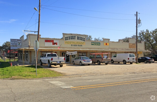
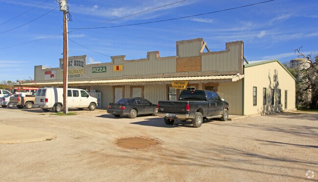
Property Record
360 W State Highway 29, Bertram, TX 78605

Property Detail
360 W State Highway 29
32723
S6600 NEW ADDITION BLK 65, NE CORNER OF B & PART OF A
Commercialnec
BURNET
B and X Area of moderate flood hazard, usually the area between the limits of the 100-year and 500-year floods.
Texas
2024
0.43 AC
2025
Bertram
960102
Other Market Areas
5,520 SF
NEARBY LISTINGS FOR SALE OR LEASE
-
-
View all Bertram listings for sale on LoopNet.com
DEMOGRAPHICS near 360 W State Highway 29
1 mile
3 mile
5 mile
2025 Total Population
2,221
3,509
6,137
2030 Population
2,456
3,879
6,810
Pop Growth 2025-2030
+ 10.58%
+ 10.54%
+ 10.97%
Average Age
41
41
41
2025 Total Households
788
1,247
2,188
HH Growth 2025-2030
+ 10.66%
+ 10.59%
+ 11.01%
Median Household Inc
$75,884
$72,531
$77,586
Avg Household Size
2.70
2.70
2.70
2025 Avg HH Vehicles
2.00
2.00
2.00
Median Home Value
$313,291
$293,068
$350,232
Median Year Built
2003
2002
2002
Nearby Places
Map Layers
Map Styles
 Street
 Aerial
Transit
 Traffic
 Biking
Places
Listings with unknown addresses are not visible on the map
- Restaurants
- Banks
- Shops
- Fitness
- Groceries
PUBLIC TRANSPORTATION
AIRPORT
Robert Gray AAF
Drive
Walk
Distance
Robert Gray AAF
61 min
34.2 mi
Freight Ports
Calhoun Port
Drive
Walk
Distance
Calhoun Port
235 min
198.0 mi
Nearby Properties
Address
Land Use
TOTAL SIZE
Lot Size
Zoning
Address
Land Use
TOTAL SIZE
Lot Size
Zoning
88,198 SF
7.81 AC
Address
Land Use
TOTAL SIZE
Lot Size
Zoning
214.12 AC
Address
Land Use
TOTAL SIZE
Lot Size
Zoning
18,403 SF
1.13 AC
Address
Land Use
TOTAL SIZE
Lot Size
Zoning
317.92 AC
Address
Land Use
TOTAL SIZE
Lot Size
Zoning
11,584 SF
4.47 AC
Address
Land Use
TOTAL SIZE
Lot Size
Zoning
27,012 SF
3.39 AC
Address
Land Use
TOTAL SIZE
Lot Size
Zoning
4,177 SF
0.50 AC
Address
Land Use
TOTAL SIZE
Lot Size
Zoning
6,185 SF
1.12 AC
Address
Land Use
TOTAL SIZE
Lot Size
Zoning
84,102 SF
10.76 AC
Address
Land Use
TOTAL SIZE
Lot Size
Zoning
1,064 SF
7 AC
Address
Land Use
TOTAL SIZE
Lot Size
Zoning
6,948 SF
1.40 AC
Address
Land Use
TOTAL SIZE
Lot Size
Zoning
8,500 SF
0.25 AC
Address
Land Use
TOTAL SIZE
Lot Size
Zoning
4,680 SF
25.16 AC
Address
Land Use
TOTAL SIZE
Lot Size
Zoning
8,656 SF
0.33 AC
Address
Land Use
TOTAL SIZE
Lot Size
Zoning
1,075 SF
9.64 AC
Address
Land Use
TOTAL SIZE
Lot Size
Zoning
9,060 SF
1.62 AC
Address
Land Use
TOTAL SIZE
Lot Size
Zoning
5,240 SF
8.56 AC
Address
Land Use
TOTAL SIZE
Lot Size
Zoning
Address
Land Use
TOTAL SIZE
Lot Size
Zoning
5,950 SF
1.61 AC
Address
Land Use
TOTAL SIZE
Lot Size
Zoning
784 SF
10.50 AC
Address
Land Use
TOTAL SIZE
Lot Size
Zoning
55.98 AC
Address
Land Use
TOTAL SIZE
Lot Size
Zoning
6,300 SF
0.64 AC
Address
Land Use
TOTAL SIZE
Lot Size
Zoning
3,220 SF
0.33 AC
Address
Land Use
TOTAL SIZE
Lot Size
Zoning
5,453 SF
3.79 AC
Address
Land Use
TOTAL SIZE
Lot Size
Zoning
5,504 SF
0.94 AC
Address
Land Use
TOTAL SIZE
Lot Size
Zoning
382 SF
10 AC
Address
Land Use
TOTAL SIZE
Lot Size
Zoning
2,704 SF
0.55 AC
Address
Land Use
TOTAL SIZE
Lot Size
Zoning
37.44 AC
Address
Land Use
TOTAL SIZE
Lot Size
Zoning
7,425 SF
5.05 AC
Address
Land Use
TOTAL SIZE
Lot Size
Zoning
9,118 SF
0.66 AC
The World's #1 Commercial Real Estate Marketplace
Connect with us
© 2026 CoStar Group
The information above has been obtained from sources believed reliable. While we do not doubt its accuracy we have not verified it and make no guarantee, warranty or representation about it. It is your responsibility to independently confirm its accuracy and completeness. Any projections, opinions, assumptions, or estimates used are for example only and do not represent the current or future performance of the property. The value of this transaction to you depends on tax and other factors which should be evaluated by your tax, financial, and legal advisors. You and your advisors should conduct a careful, independent investigation of the property to determine to your satisfaction the suitability of the property for your needs.