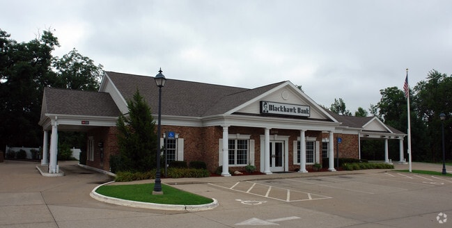
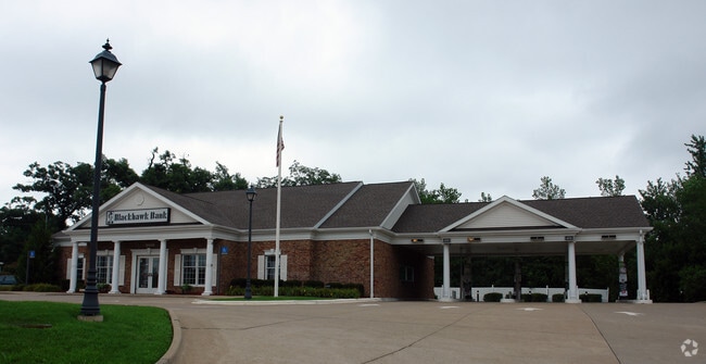
Property Record
3600 70Th St, Moline, IL 61265

Property Detail
3600 70Th St
17-12-301-001
LOT 1 PINNACLE SUBD & PT VAC ROW WLY & ADJ TO
Commercialnec
Rock Island
MOL
Illinois
B and X Area of moderate flood hazard, usually the area between the limits of the 100-year and 500-year floods.
1
2024
1.19 AC
2024
Outlying Rock Island Cnty
021100
Davenport/Moline/Rock Island
3,693 SF
Davenport-Moline-Rock Island, IA-IL
NEARBY LISTINGS FOR SALE OR LEASE
DEMOGRAPHICS near 3600 70Th St
1 mile
3 mile
5 mile
2025 Total Population
6,554
48,093
87,723
2030 Population
6,552
47,908
87,459
Pop Growth 2025-2030
(0.03%)
(0.38%)
(0.30%)
Average Age
41
42
41
2025 Total Households
2,983
20,884
37,576
HH Growth 2025-2030
(0.10%)
(0.35%)
(0.29%)
Median Household Inc
$65,379
$69,133
$66,143
Avg Household Size
2.10
2.20
2.30
2025 Avg HH Vehicles
2.00
2.00
2.00
Median Home Value
$238,713
$169,493
$161,363
Median Year Built
1979
1967
1961
Nearby Places
Map Layers
Map Styles
 Street
 Aerial
Layers
 Traffic
 Biking
Places
Listings with unknown addresses are not visible on the map
- Restaurants
- Banks
- Shops
- Fitness
- Groceries
PUBLIC TRANSPORTATION
AIRPORT
Quad Cities International
Drive
Walk
Distance
Quad Cities International
11 min
5.1 mi
Freight Ports
Port Milwaukee
Drive
Walk
Distance
Port Milwaukee
230 min
203.6 mi
Nearby Properties
Address
Land Use
TOTAL SIZE
Lot Size
Zoning
Address
Land Use
TOTAL SIZE
Lot Size
Zoning
333.38 AC
B3
Address
Land Use
TOTAL SIZE
Lot Size
Zoning
197,382 SF
14.06 AC
EM
Address
Land Use
TOTAL SIZE
Lot Size
Zoning
166,102 SF
4.36 AC
SIL
Address
Land Use
TOTAL SIZE
Lot Size
Zoning
250,875 SF
11.92 AC
MOL
Address
Land Use
TOTAL SIZE
Lot Size
Zoning
333,348 SF
30.81 AC
EM
Address
Land Use
TOTAL SIZE
Lot Size
Zoning
132,647 SF
13.76 AC
MOL
Address
Land Use
TOTAL SIZE
Lot Size
Zoning
196,305 SF
24.75 AC
SIL
Address
Land Use
TOTAL SIZE
Lot Size
Zoning
19.69 AC
MOL
Address
Land Use
TOTAL SIZE
Lot Size
Zoning
194,267 SF
23.16 AC
MOL
Address
Land Use
TOTAL SIZE
Lot Size
Zoning
244,440 SF
13.25 AC
MOL
Address
Land Use
TOTAL SIZE
Lot Size
Zoning
10.75 AC
MOL
Address
Land Use
TOTAL SIZE
Lot Size
Zoning
46,917 SF
4.57 AC
SIL
Address
Land Use
TOTAL SIZE
Lot Size
Zoning
142,836 SF
14.60 AC
MOL
Address
Land Use
TOTAL SIZE
Lot Size
Zoning
203,904 SF
12.75 AC
MOL
Address
Land Use
TOTAL SIZE
Lot Size
Zoning
47,578 SF
23.65 AC
MOL
Address
Land Use
TOTAL SIZE
Lot Size
Zoning
45,000 SF
2.52 AC
SIL
Address
Land Use
TOTAL SIZE
Lot Size
Zoning
134,142 SF
13.31 AC
EM
Address
Land Use
TOTAL SIZE
Lot Size
Zoning
9.18 AC
MOL
Address
Land Use
TOTAL SIZE
Lot Size
Zoning
3.12 AC
SIL
Address
Land Use
TOTAL SIZE
Lot Size
Zoning
144,306 SF
16.90 AC
EM
Address
Land Use
TOTAL SIZE
Lot Size
Zoning
162,924 SF
17.18 AC
MOL
Address
Land Use
TOTAL SIZE
Lot Size
Zoning
55.60 AC
CV
Address
Land Use
TOTAL SIZE
Lot Size
Zoning
30,836 SF
4.91 AC
MOL
Address
Land Use
TOTAL SIZE
Lot Size
Zoning
433,640 SF
32.30 AC
EM
Address
Land Use
TOTAL SIZE
Lot Size
Zoning
46.02 AC
MOL
Address
Land Use
TOTAL SIZE
Lot Size
Zoning
10.76 AC
MOL
Address
Land Use
TOTAL SIZE
Lot Size
Zoning
107,880 SF
1.79 AC
EM
Address
Land Use
TOTAL SIZE
Lot Size
Zoning
81,027 SF
6.57 AC
SIL
Address
Land Use
TOTAL SIZE
Lot Size
Zoning
130,200 SF
3 AC
EM
Address
Land Use
TOTAL SIZE
Lot Size
Zoning
The World's #1 Commercial Real Estate Marketplace
Connect with us
© 2026 CoStar Group
The information above has been obtained from sources believed reliable. While we do not doubt its accuracy we have not verified it and make no guarantee, warranty or representation about it. It is your responsibility to independently confirm its accuracy and completeness. Any projections, opinions, assumptions, or estimates used are for example only and do not represent the current or future performance of the property. The value of this transaction to you depends on tax and other factors which should be evaluated by your tax, financial, and legal advisors. You and your advisors should conduct a careful, independent investigation of the property to determine to your satisfaction the suitability of the property for your needs.