Property Record
Vac/35Th St E Vic Palmdale Blvd E, Palmdale, CA 93552


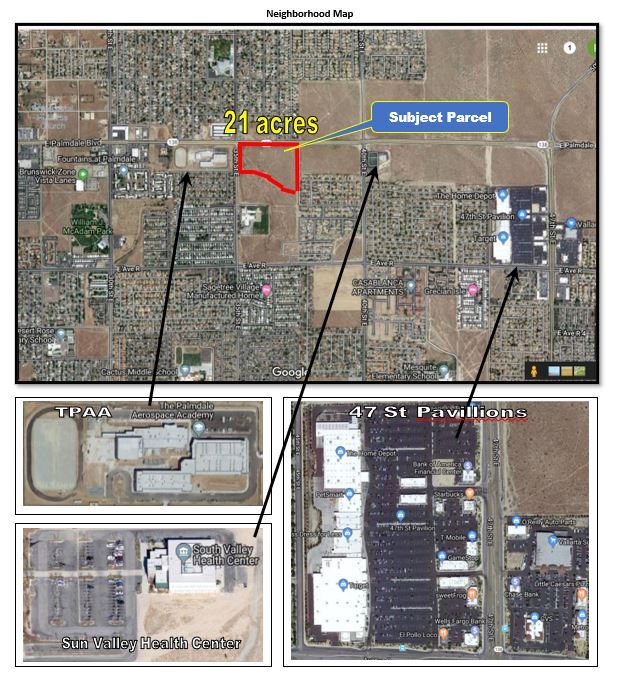
This Property Is For Sale
NEARBY LISTINGS FOR SALE OR LEASE
Property Detail
Vac/35Th St E Vic Palmdale Blvd E
Los Angeles-Long Beach-Glendale, CA
P M 404-59-64 LOT 2
3020-014-019
Los Angeles
Commercialacreage
California
X
2
06037C0700F
21.83 AC
2024
Antelope Valley
2025
Los Angeles
910714
DEMOGRAPHICS near Vac/35Th St E Vic Palmdale Blvd E
1 Mile
3 Mile
5 Mile
2024 Total Population
17,073
99,681
128,106
2029 Population
16,436
96,322
124,143
Pop Growth 2024-2029
(3.73%)
(3.37%)
(3.09%)
Average Age
35
35
35
2024 Total Households
4,621
27,355
35,825
HH Growth 2024-2029
(3.92%)
(3.46%)
(3.19%)
Median Household Inc
$54,166
$61,248
$61,660
Avg Household Size
3.60
3.60
3.50
2024 Avg HH Vehicles
2.00
2.00
2.00
Median Home Value
$210,018
$298,488
$310,140
Median Year Built
1985
1987
1986
Nearby Places
- Restaurants
- Banks
- Shops
- Fitness
- Groceries
PUBLIC TRANSPORTATION
COMMUTER RAIL
Palmdale (Antelope Valley Line - Southern California Regional Rail Authority (Metrolink))
DRIVE
WALK
Distance
Palmdale (Antelope Valley Line - Southern California Regional Rail Authority (Metrolink))
5 min
3.8 mi
Vincent Grade/Acton (Antelope Valley Line - Southern California Regional Rail Authority (Metrolink))
DRIVE
WALK
Distance
Vincent Grade/Acton (Antelope Valley Line - Southern California Regional Rail Authority (Metrolink))
12 min
7.9 mi
Freight Ports
Port of Long Beach
DRIVE
WALK
Distance
Port of Long Beach
103 min
86.3 mi
Nearby Properties
Address
Land Use
TOTAL SIZE
Lot Size
Zoning
Address
Land Use
TOTAL SIZE
Lot Size
Zoning
167,366 SF
15.36 AC
PDC3
Address
Land Use
TOTAL SIZE
Lot Size
Zoning
172,894 SF
14.26 AC
PDC3*
Address
Land Use
TOTAL SIZE
Lot Size
Zoning
221,536 SF
18.81 AC
PDR17000*
Address
Land Use
TOTAL SIZE
Lot Size
Zoning
101,172 SF
10.22 AC
PDR1*
Address
Land Use
TOTAL SIZE
Lot Size
Zoning
221,827 SF
14.90 AC
PDRPD10U-R
Address
Land Use
TOTAL SIZE
Lot Size
Zoning
157,021 SF
PDRN4
Address
Land Use
TOTAL SIZE
Lot Size
Zoning
209,328 SF
6.35 AC
PDC3-RPD15
Address
Land Use
TOTAL SIZE
Lot Size
Zoning
138,375 SF
7.83 AC
PDR17000*
Address
Land Use
TOTAL SIZE
Lot Size
Zoning
76,609 SF
3.61 AC
PDM2
Address
Land Use
TOTAL SIZE
Lot Size
Zoning
2,908,124 SF
126.15 AC
LCM21/2*
Address
Land Use
TOTAL SIZE
Lot Size
Zoning
81,790 SF
5.70 AC
PDR1*
Address
Land Use
TOTAL SIZE
Lot Size
Zoning
78,176 SF
6.11 AC
PDR1*
Address
Land Use
TOTAL SIZE
Lot Size
Zoning
81,512 SF
4.25 AC
PDR1*
Address
Land Use
TOTAL SIZE
Lot Size
Zoning
67,560 SF
5.12 AC
PDR1*
Address
Land Use
TOTAL SIZE
Lot Size
Zoning
63,944 SF
2.33 AC
PDR1-7000
Address
Land Use
TOTAL SIZE
Lot Size
Zoning
8.42 AC
PDR2
Address
Land Use
TOTAL SIZE
Lot Size
Zoning
43,898 SF
4 AC
PDR1*
Address
Land Use
TOTAL SIZE
Lot Size
Zoning
47,826 SF
5.92 AC
PDC3*
Address
Land Use
TOTAL SIZE
Lot Size
Zoning
153,879 SF
12.37 AC
PDR3*
Address
Land Use
TOTAL SIZE
Lot Size
Zoning
106,048 SF
9.82 AC
PDR3*
Address
Land Use
TOTAL SIZE
Lot Size
Zoning
225,054 SF
PDC3
Address
Land Use
TOTAL SIZE
Lot Size
Zoning
154,988 SF
PDR3*
Address
Land Use
TOTAL SIZE
Lot Size
Zoning
85,392 SF
4.36 AC
PDR3*
Address
Land Use
TOTAL SIZE
Lot Size
Zoning
111,132 SF
6.53 AC
PDR3DP-R3*
Address
Land Use
TOTAL SIZE
Lot Size
Zoning
53,896 SF
6.45 AC
PDC3
Address
Land Use
TOTAL SIZE
Lot Size
Zoning
38,493 SF
3.23 AC
PDR1*
Address
Land Use
TOTAL SIZE
Lot Size
Zoning
96,224 SF
4.18 AC
PDR3*
Address
Land Use
TOTAL SIZE
Lot Size
Zoning
53,456 SF
8.69 AC
PDC3
Address
Land Use
TOTAL SIZE
Lot Size
Zoning
85,955 SF
4.30 AC
LCC3*
Address
Land Use
TOTAL SIZE
Lot Size
Zoning
56,256 SF
4.89 AC
LCR325U*
The World's #1 Commercial Real Estate Marketplace
Connect with us
© 2025 CoStar Group
The information above has been obtained from sources believed reliable. While we do not doubt its accuracy we have not verified it and make no guarantee, warranty or representation about it. It is your responsibility to independently confirm its accuracy and completeness. Any projections, opinions, assumptions, or estimates used are for example only and do not represent the current or future performance of the property. The value of this transaction to you depends on tax and other factors which should be evaluated by your tax, financial, and legal advisors. You and your advisors should conduct a careful, independent investigation of the property to determine to your satisfaction the suitability of the property for your needs.