Property Record
3600 Mapleshade Ln, Plano, TX 75075
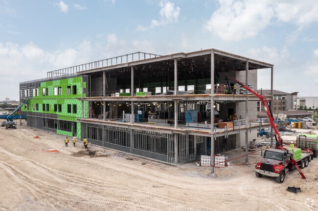

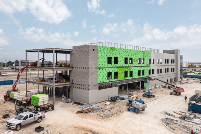

Property Detail
3600 Mapleshade Ln
Dallas-Fort Worth-Arlington, TX
FIRST BAPTIST 190 ADDITION, BLK A, LOT 3
R-11803-00A-0030-1
COLLIN
Officebuilding
Texas
B and X Area of moderate flood hazard, usually the area between the limits of the 100-year and 500-year floods.
3
2025
2.52 AC
2025
Richardson
031811
Dallas/Ft Worth
55,617 SF
NEARBY LISTINGS FOR SALE OR LEASE
DEMOGRAPHICS near 3600 Mapleshade Ln
1 mile
3 mile
5 mile
2024 Total Population
15,147
132,476
365,521
2029 Population
18,254
152,316
413,571
Pop Growth 2024-2029
+ 20.51%
+ 14.98%
+ 13.15%
Average Age
36
40
39
2024 Total Households
6,193
54,126
153,326
HH Growth 2024-2029
+ 23.66%
+ 16.42%
+ 13.61%
Median Household Inc
$59,227
$82,019
$81,767
Avg Household Size
1.90
2.30
2.30
2024 Avg HH Vehicles
1.00
2.00
2.00
Median Home Value
$416,107
$391,062
$384,671
Median Year Built
2009
1983
1985
Nearby Places
Map Layers
Map Styles
 Street
 Aerial
Transit
 Traffic
 Biking
Places
Listings with unknown addresses are not visible on the map
- Restaurants
- Banks
- Shops
- Fitness
- Groceries
PUBLIC TRANSPORTATION
AIRPORT
Dallas Love Field
Drive
Walk
Distance
Dallas Love Field
28 min
19.8 mi
Dallas-Fort Worth International
Drive
Walk
Distance
Dallas-Fort Worth International
30 min
24.3 mi
Nearby Properties
Address
Land Use
TOTAL SIZE
Lot Size
Zoning
Address
Land Use
TOTAL SIZE
Lot Size
Zoning
1,049,441 SF
Address
Land Use
TOTAL SIZE
Lot Size
Zoning
1,614,550 SF
77.76 AC
SFR
Address
Land Use
TOTAL SIZE
Lot Size
Zoning
492,661 SF
4.89 AC
Address
Land Use
TOTAL SIZE
Lot Size
Zoning
343,539 SF
34.74 AC
S-164
Address
Land Use
TOTAL SIZE
Lot Size
Zoning
1,105,509 SF
92.46 AC
A
Address
Land Use
TOTAL SIZE
Lot Size
Zoning
659,402 SF
24.39 AC
O-M
Address
Land Use
TOTAL SIZE
Lot Size
Zoning
686,032 SF
9 AC
R2000
Address
Land Use
TOTAL SIZE
Lot Size
Zoning
606,071 SF
64.75 AC
SFR
Address
Land Use
TOTAL SIZE
Lot Size
Zoning
369,694 SF
Address
Land Use
TOTAL SIZE
Lot Size
Zoning
533,962 SF
29.78 AC
MF-M
Address
Land Use
TOTAL SIZE
Lot Size
Zoning
445,071 SF
107.94 AC
2493-A TO-
Address
Land Use
TOTAL SIZE
Lot Size
Zoning
481,366 SF
6.31 AC
LC
Address
Land Use
TOTAL SIZE
Lot Size
Zoning
430,618 SF
11.33 AC
MF-H
Address
Land Use
TOTAL SIZE
Lot Size
Zoning
394,287 SF
14.96 AC
Address
Land Use
TOTAL SIZE
Lot Size
Zoning
507,693 SF
32.50 AC
MFL
Address
Land Use
TOTAL SIZE
Lot Size
Zoning
520,713 SF
8.03 AC
Address
Land Use
TOTAL SIZE
Lot Size
Zoning
393,416 SF
Address
Land Use
TOTAL SIZE
Lot Size
Zoning
451,672 SF
23.81 AC
LI-1
Address
Land Use
TOTAL SIZE
Lot Size
Zoning
509,566 SF
34.05 AC
PD
Address
Land Use
TOTAL SIZE
Lot Size
Zoning
289,093 SF
8.87 AC
R/O-2
Address
Land Use
TOTAL SIZE
Lot Size
Zoning
284,830 SF
2.98 AC
Address
Land Use
TOTAL SIZE
Lot Size
Zoning
386,448 SF
Address
Land Use
TOTAL SIZE
Lot Size
Zoning
324,000 SF
6.67 AC
O-S
Address
Land Use
TOTAL SIZE
Lot Size
Zoning
421,532 SF
4.29 AC
Address
Land Use
TOTAL SIZE
Lot Size
Zoning
64.94 AC
Address
Land Use
TOTAL SIZE
Lot Size
Zoning
245,542 SF
26.31 AC
RT/O-M
Address
Land Use
TOTAL SIZE
Lot Size
Zoning
408,256 SF
27.66 AC
MF-M
Address
Land Use
TOTAL SIZE
Lot Size
Zoning
681,916 SF
4.80 AC
Z31
Address
Land Use
TOTAL SIZE
Lot Size
Zoning
488,063 SF
31.19 AC
MF-L
The World's #1 Commercial Real Estate Marketplace
Connect with us
© 2026 CoStar Group
The information above has been obtained from sources believed reliable. While we do not doubt its accuracy we have not verified it and make no guarantee, warranty or representation about it. It is your responsibility to independently confirm its accuracy and completeness. Any projections, opinions, assumptions, or estimates used are for example only and do not represent the current or future performance of the property. The value of this transaction to you depends on tax and other factors which should be evaluated by your tax, financial, and legal advisors. You and your advisors should conduct a careful, independent investigation of the property to determine to your satisfaction the suitability of the property for your needs.