Property Record
3600 S Glenstone Outer Rd, Springfield, MO 65804
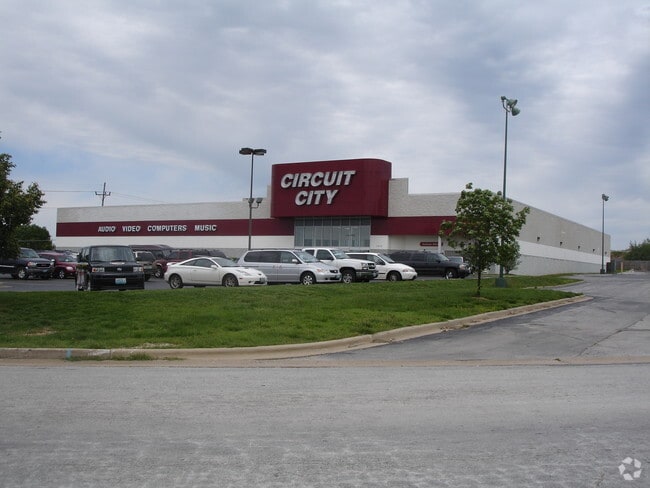
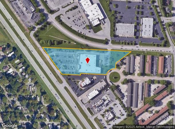
Property Detail
3600 S Glenstone Outer Rd
Springfield, MO
Mc Callisters Ests
19-08-201-063
MC CALLISTERS ESTS SUB DIV PT LOTS 3 & 4 BEG NW COR LOT 4 E 1014.25 FT SWLY205.58 FT S 61.51 FT TO N R/W MACS CT SWLY AL G R/W 128.92 FT W 264.86 FT S 19 FTW 268.76 FT TO ELY R/W GL
Departmentstore
Greene
X
Missouri
29077C0344E
3-4
2025
4.81 AC
2025
Southeast
002600
Springfield
39,204 SF
NEARBY LISTINGS FOR SALE OR LEASE
DEMOGRAPHICS near 3600 S Glenstone Outer Rd
1 mile
3 mile
5 mile
2024 Total Population
7,072
58,478
144,879
2029 Population
7,329
60,373
150,378
Pop Growth 2024-2029
+ 3.63%
+ 3.24%
+ 3.80%
Average Age
45
42
39
2024 Total Households
3,498
27,740
65,711
HH Growth 2024-2029
+ 3.83%
+ 3.47%
+ 4.08%
Median Household Inc
$52,854
$54,576
$50,976
Avg Household Size
2.00
2.00
2.10
2024 Avg HH Vehicles
2.00
2.00
2.00
Median Home Value
$216,413
$189,613
$194,040
Median Year Built
1982
1978
1981
Nearby Places
Map Layers
Map Styles
 Street
 Aerial
Transit
 Traffic
 Biking
Places
Listings with unknown addresses are not visible on the map
- Restaurants
- Banks
- Shops
- Fitness
- Groceries
PUBLIC TRANSPORTATION
AIRPORT
Springfield-Branson Ntl
Drive
Walk
Distance
Springfield-Branson Ntl
34 min
15.2 mi
Nearby Properties
Address
Land Use
TOTAL SIZE
Lot Size
Zoning
Address
Land Use
TOTAL SIZE
Lot Size
Zoning
2,981,315 SF
76.43 AC
INC
Address
Land Use
TOTAL SIZE
Lot Size
Zoning
15.46 AC
Address
Land Use
TOTAL SIZE
Lot Size
Zoning
299,725 SF
18.80 AC
INC
Address
Land Use
TOTAL SIZE
Lot Size
Zoning
284,904 SF
24.38 AC
INC
Address
Land Use
TOTAL SIZE
Lot Size
Zoning
376,072 SF
17.67 AC
INC
Address
Land Use
TOTAL SIZE
Lot Size
Zoning
12.74 AC
Address
Land Use
TOTAL SIZE
Lot Size
Zoning
210,374 SF
24.37 AC
INC
Address
Land Use
TOTAL SIZE
Lot Size
Zoning
180,665 SF
6.36 AC
INC
Address
Land Use
TOTAL SIZE
Lot Size
Zoning
15.46 AC
INC.
Address
Land Use
TOTAL SIZE
Lot Size
Zoning
779,221 SF
45.03 AC
INC
Address
Land Use
TOTAL SIZE
Lot Size
Zoning
1.98 AC
INC.
Address
Land Use
TOTAL SIZE
Lot Size
Zoning
105,278 SF
0.54 AC
INC
Address
Land Use
TOTAL SIZE
Lot Size
Zoning
2.31 AC
INC
Address
Land Use
TOTAL SIZE
Lot Size
Zoning
108,880 SF
3.62 AC
INC
Address
Land Use
TOTAL SIZE
Lot Size
Zoning
224,730 SF
19.99 AC
INC
Address
Land Use
TOTAL SIZE
Lot Size
Zoning
2.76 AC
INC.
Address
Land Use
TOTAL SIZE
Lot Size
Zoning
10.29 AC
INC.
Address
Land Use
TOTAL SIZE
Lot Size
Zoning
26.03 AC
INC
Address
Land Use
TOTAL SIZE
Lot Size
Zoning
51.65 AC
INC
Address
Land Use
TOTAL SIZE
Lot Size
Zoning
211,041 SF
19.13 AC
INC
Address
Land Use
TOTAL SIZE
Lot Size
Zoning
11.56 AC
INC
Address
Land Use
TOTAL SIZE
Lot Size
Zoning
3.43 AC
INC
Address
Land Use
TOTAL SIZE
Lot Size
Zoning
17.07 AC
INC.
Address
Land Use
TOTAL SIZE
Lot Size
Zoning
1.99 AC
INC
Address
Land Use
TOTAL SIZE
Lot Size
Zoning
8.24 AC
INC
Address
Land Use
TOTAL SIZE
Lot Size
Zoning
140,147 SF
17.64 AC
INC
Address
Land Use
TOTAL SIZE
Lot Size
Zoning
324,341 SF
43 AC
INC
Address
Land Use
TOTAL SIZE
Lot Size
Zoning
42,540 SF
3.63 AC
INC
Address
Land Use
TOTAL SIZE
Lot Size
Zoning
12.90 AC
INC
Address
Land Use
TOTAL SIZE
Lot Size
Zoning
6.50 AC
INC.
The World's #1 Commercial Real Estate Marketplace
Connect with us
© 2026 CoStar Group
The information above has been obtained from sources believed reliable. While we do not doubt its accuracy we have not verified it and make no guarantee, warranty or representation about it. It is your responsibility to independently confirm its accuracy and completeness. Any projections, opinions, assumptions, or estimates used are for example only and do not represent the current or future performance of the property. The value of this transaction to you depends on tax and other factors which should be evaluated by your tax, financial, and legal advisors. You and your advisors should conduct a careful, independent investigation of the property to determine to your satisfaction the suitability of the property for your needs.