Property Record
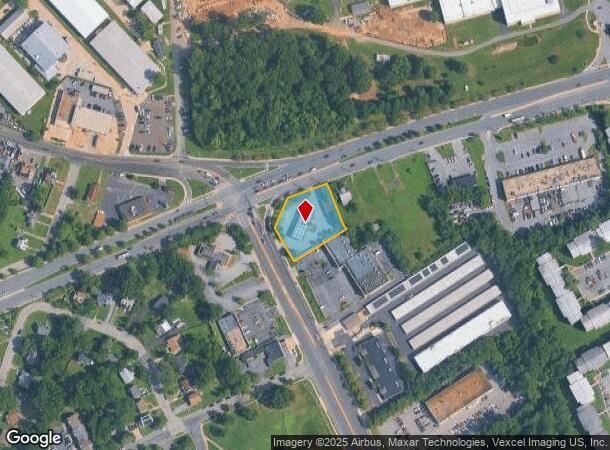
3600 Saint Barnabas Rd, Suitland, MD 20746


NEARBY LISTINGS FOR SALE OR LEASE
Property Detail
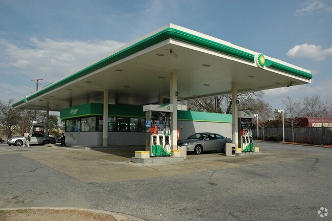
3600 Saint Barnabas Rd
06-0415927
PARCEL A EX 672 SQ FT CERT OF MERGER 9/28/01
Storebuilding
Prince George's
X
Maryland
24033C0230E
a
2024
0.66 AC
2025
Branch Avenue Corridor
801908
Washington, DC
1,196 SF
Washington-Arlington-Alexandria, DC-VA-MD-WV
DEMOGRAPHICS near 3600 Saint Barnabas Rd
1 Mile
3 Mile
5 Mile
2024 Total Population
16,354
176,504
429,203
2029 Population
16,030
167,775
406,403
Pop Growth 2024-2029
(1.98%)
(4.95%)
(5.31%)
Average Age
40
39
39
2024 Total Households
7,222
72,565
178,984
HH Growth 2024-2029
(2.01%)
(5.30%)
(5.90%)
Median Household Inc
$61,866
$60,573
$71,082
Avg Household Size
2.20
2.40
2.30
2024 Avg HH Vehicles
1.00
1.00
1.00
Median Home Value
$268,223
$322,993
$364,249
Median Year Built
1966
1966
1965
Nearby Places
Map Layers
Map Styles
 Street
 Aerial
- Restaurants
- Banks
- Shops
- Fitness
- Groceries
PUBLIC TRANSPORTATION
TRANSIT/SUBWAY
Suitland (Green Line - Washington Metropolitan Area Transit Authority Metrorail (Metrorail))
DRIVE
WALK
Distance
Suitland (Green Line - Washington Metropolitan Area Transit Authority Metrorail (Metrorail))
5 min
19 min
1.0 mi
COMMUTER RAIL
Union Station (Red Line - Washington Metropolitan Area Transit Authority Metrorail (Metrorail))
DRIVE
WALK
Distance
Union Station (Red Line - Washington Metropolitan Area Transit Authority Metrorail (Metrorail))
15 min
6.1 mi
DRIVE
WALK
Distance
15 min
6.5 mi
AIRPORT
Ronald Reagan Washington Ntl
DRIVE
WALK
Distance
Ronald Reagan Washington Ntl
22 min
11.3 mi
Baltimore/Washington International Thurgood Marshall
DRIVE
WALK
Distance
Baltimore/Washington International Thurgood Marshall
51 min
33.0 mi
Washington Dulles International
DRIVE
WALK
Distance
Washington Dulles International
59 min
35.6 mi
Freight Ports
Port of Baltimore
DRIVE
WALK
Distance
Port of Baltimore
60 min
39.3 mi
Nearby Properties
Address
Land Use
TOTAL SIZE
Lot Size
Zoning
Address
Land Use
TOTAL SIZE
Lot Size
Zoning
169.85 AC
R-2;RA-1;U
Address
Land Use
TOTAL SIZE
Lot Size
Zoning
2,131,229 SF
144.34 AC
AG
Address
Land Use
TOTAL SIZE
Lot Size
Zoning
450,000 SF
37.35 AC
UNZONED
Address
Land Use
TOTAL SIZE
Lot Size
Zoning
963,250 SF
10.71 AC
RTOLE
Address
Land Use
TOTAL SIZE
Lot Size
Zoning
417 SF
7.66 AC
RTOLE
Address
Land Use
TOTAL SIZE
Lot Size
Zoning
274,244 SF
6.24 AC
RA-1
Address
Land Use
TOTAL SIZE
Lot Size
Zoning
26.64 AC
RMF20
Address
Land Use
TOTAL SIZE
Lot Size
Zoning
68,992 SF
3.19 AC
STE-12;STE
Address
Land Use
TOTAL SIZE
Lot Size
Zoning
450 SF
20.72 AC
RMF20
Address
Land Use
TOTAL SIZE
Lot Size
Zoning
6 AC
RTOLE
Address
Land Use
TOTAL SIZE
Lot Size
Zoning
62,797 SF
0.55 AC
R2
Address
Land Use
TOTAL SIZE
Lot Size
Zoning
348,525 SF
11 AC
STE-11
Address
Land Use
TOTAL SIZE
Lot Size
Zoning
473,030 SF
3.08 AC
RA-1
Address
Land Use
TOTAL SIZE
Lot Size
Zoning
29.24 AC
RMF20
Address
Land Use
TOTAL SIZE
Lot Size
Zoning
45.36 AC
MU-1;RA-1
Address
Land Use
TOTAL SIZE
Lot Size
Zoning
262 SF
24.86 AC
RMF20
Address
Land Use
TOTAL SIZE
Lot Size
Zoning
232,095 SF
8.25 AC
RA-2
Address
Land Use
TOTAL SIZE
Lot Size
Zoning
701 SF
29.42 AC
RMF20
Address
Land Use
TOTAL SIZE
Lot Size
Zoning
450 SF
21.14 AC
RMF20
Address
Land Use
TOTAL SIZE
Lot Size
Zoning
40.63 AC
RA-1
Address
Land Use
TOTAL SIZE
Lot Size
Zoning
13.21 AC
RMF48
Address
Land Use
TOTAL SIZE
Lot Size
Zoning
115,788 SF
1.77 AC
MU-4;RA-1
Address
Land Use
TOTAL SIZE
Lot Size
Zoning
29.49 AC
RSFA
Address
Land Use
TOTAL SIZE
Lot Size
Zoning
17.90 AC
RMF20
Address
Land Use
TOTAL SIZE
Lot Size
Zoning
21.48 AC
RMF20
Address
Land Use
TOTAL SIZE
Lot Size
Zoning
891,284 SF
10.18 AC
RA-2
Address
Land Use
TOTAL SIZE
Lot Size
Zoning
22.67 AC
RMF20
Address
Land Use
TOTAL SIZE
Lot Size
Zoning
138,912 SF
4.59 AC
RA-1
Address
Land Use
TOTAL SIZE
Lot Size
Zoning
192,777 SF
20.65 AC
RA-1
Address
Land Use
TOTAL SIZE
Lot Size
Zoning
383,961 SF
2.90 AC
MU-7B
The World's #1 Commercial Real Estate Marketplace
Connect with us
© 2025 CoStar Group
The information above has been obtained from sources believed reliable. While we do not doubt its accuracy we have not verified it and make no guarantee, warranty or representation about it. It is your responsibility to independently confirm its accuracy and completeness. Any projections, opinions, assumptions, or estimates used are for example only and do not represent the current or future performance of the property. The value of this transaction to you depends on tax and other factors which should be evaluated by your tax, financial, and legal advisors. You and your advisors should conduct a careful, independent investigation of the property to determine to your satisfaction the suitability of the property for your needs.