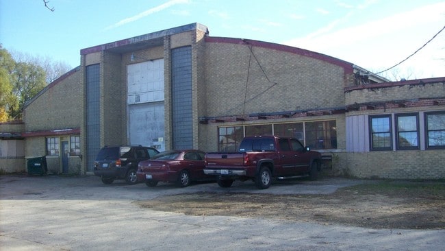
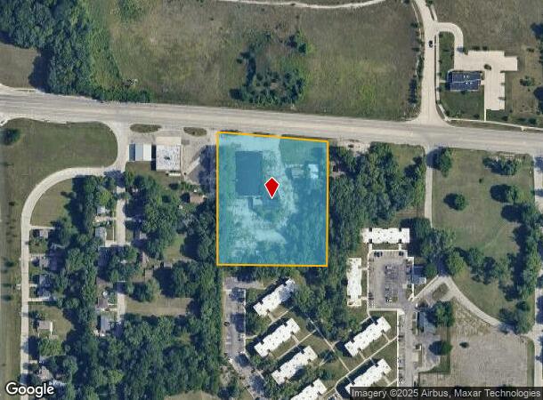
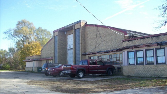
Property Record
3600 W State St, Rockford, IL 61102
NEARBY LISTINGS FOR SALE OR LEASE
Property Detail
3600 W State St
11-20-254-001
INC HWY ALL BEGN INSECTN C/L STATE RD850 FT E OF W LN NE 1/4 TH S 472.94 FTTH E 327.90 FT ON LN 175 FT N OF N LNELM ST WASH PK PLAT PROD W TH N 448.1
Industrialgeneral
Winnebago
X
Illinois
17201C0244D
44
2024
3.74 AC
2024
I-39 Cor/Winnebago Cy
002400
Chicago
27,263 SF
Rockford, IL
DEMOGRAPHICS near 3600 W State St
1 Mile
3 Mile
5 Mile
2024 Total Population
6,953
43,274
100,306
2029 Population
7,017
43,415
99,554
Pop Growth 2024-2029
+ 0.92%
+ 0.33%
(0.75%)
Average Age
36
37
38
2024 Total Households
2,560
16,587
40,167
HH Growth 2024-2029
+ 0.86%
+ 0.26%
(0.85%)
Median Household Inc
$29,999
$32,025
$39,794
Avg Household Size
2.60
2.50
2.40
2024 Avg HH Vehicles
2.00
1.00
2.00
Median Home Value
$65,929
$73,984
$86,148
Median Year Built
1958
1953
1953
Nearby Places
Map Layers
Map Styles
 Street
 Aerial
- Restaurants
- Banks
- Shops
- Fitness
- Groceries
PUBLIC TRANSPORTATION
AIRPORT
Chicago/Rockford International
DRIVE
WALK
Distance
Chicago/Rockford International
19 min
9.9 mi
Freight Ports
Port Milwaukee
DRIVE
WALK
Distance
Port Milwaukee
118 min
96.6 mi
SALE & LEASE HISTORY
LISTING DATE
SALE/LEASE

Nov 18, 2016
For Sale
Jan 26, 2018
For Sale
Nearby Properties
Address
Land Use
TOTAL SIZE
Lot Size
Zoning
Address
Land Use
TOTAL SIZE
Lot Size
Zoning
1,456,216 SF
103.10 AC
I1
Address
Land Use
TOTAL SIZE
Lot Size
Zoning
216,540 SF
22 AC
C3
Address
Land Use
TOTAL SIZE
Lot Size
Zoning
201,507 SF
C4
Address
Land Use
TOTAL SIZE
Lot Size
Zoning
115,095 SF
0.25 AC
C4
Address
Land Use
TOTAL SIZE
Lot Size
Zoning
117,360 SF
1.52 AC
R4
Address
Land Use
TOTAL SIZE
Lot Size
Zoning
111,491 SF
0.32 AC
C4
Address
Land Use
TOTAL SIZE
Lot Size
Zoning
79,318 SF
1.55 AC
C4
Address
Land Use
TOTAL SIZE
Lot Size
Zoning
43.23 AC
I1
Address
Land Use
TOTAL SIZE
Lot Size
Zoning
238,884 SF
15.96 AC
R3
Address
Land Use
TOTAL SIZE
Lot Size
Zoning
108,233 SF
0.34 AC
C4
Address
Land Use
TOTAL SIZE
Lot Size
Zoning
153,461 SF
19.35 AC
I2
Address
Land Use
TOTAL SIZE
Lot Size
Zoning
77,936 SF
1.71 AC
C4
Address
Land Use
TOTAL SIZE
Lot Size
Zoning
239,792 SF
0.25 AC
C4
Address
Land Use
TOTAL SIZE
Lot Size
Zoning
299,238 SF
18.84 AC
I2
Address
Land Use
TOTAL SIZE
Lot Size
Zoning
137,546 SF
0.71 AC
C4
Address
Land Use
TOTAL SIZE
Lot Size
Zoning
111,696 SF
11.99 AC
CG
Address
Land Use
TOTAL SIZE
Lot Size
Zoning
118,780 SF
30.47 AC
I2
Address
Land Use
TOTAL SIZE
Lot Size
Zoning
133,645 SF
5.51 AC
R4
Address
Land Use
TOTAL SIZE
Lot Size
Zoning
24.05 AC
IH
Address
Land Use
TOTAL SIZE
Lot Size
Zoning
40,812 SF
0.24 AC
C4
Address
Land Use
TOTAL SIZE
Lot Size
Zoning
46,872 SF
2.13 AC
R1
Address
Land Use
TOTAL SIZE
Lot Size
Zoning
210,980 SF
12.56 AC
I1
Address
Land Use
TOTAL SIZE
Lot Size
Zoning
47,940 SF
0.34 AC
C4
Address
Land Use
TOTAL SIZE
Lot Size
Zoning
195,360 SF
28.13 AC
I1
Address
Land Use
TOTAL SIZE
Lot Size
Zoning
37,525 SF
C4
Address
Land Use
TOTAL SIZE
Lot Size
Zoning
111,700 SF
1.32 AC
C1
Address
Land Use
TOTAL SIZE
Lot Size
Zoning
40,446 SF
3.92 AC
C3
Address
Land Use
TOTAL SIZE
Lot Size
Zoning
104,956 SF
3.82 AC
R4
Address
Land Use
TOTAL SIZE
Lot Size
Zoning
113,902 SF
16.26 AC
R3
Address
Land Use
TOTAL SIZE
Lot Size
Zoning
34,295 SF
1.92 AC
C4
The World's #1 Commercial Real Estate Marketplace
Connect with us
© 2025 CoStar Group
The information above has been obtained from sources believed reliable. While we do not doubt its accuracy we have not verified it and make no guarantee, warranty or representation about it. It is your responsibility to independently confirm its accuracy and completeness. Any projections, opinions, assumptions, or estimates used are for example only and do not represent the current or future performance of the property. The value of this transaction to you depends on tax and other factors which should be evaluated by your tax, financial, and legal advisors. You and your advisors should conduct a careful, independent investigation of the property to determine to your satisfaction the suitability of the property for your needs.