Property Record
3601 W 145Th St, Burnsville, MN 55306
Current Lease Availabilities
NEARBY LISTINGS FOR SALE OR LEASE
-
-
View all Burnsville listings for lease on LoopNet.com
Property Detail
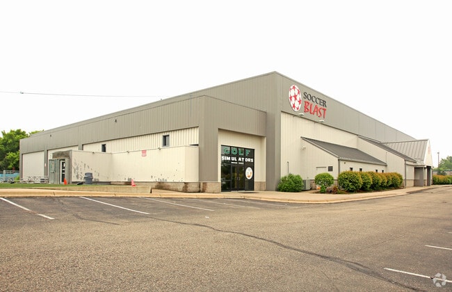
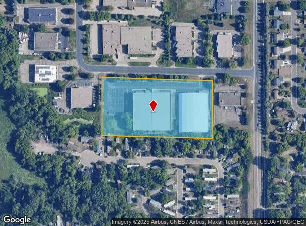
3601 W 145Th St
Minneapolis-St. Paul-Bloomington, MN-WI
Burnscott Industrial Park
02-15385-01-081
BURNSCOTT INDUSTRIAL PARK 8 1 LOTS 6 7 &
Industrialgeneral
Dakota
X
Minnesota
27037C0177E
6
2024
4.51 AC
2024
Burnsville/Eagan/Apple Vy
060739
Minneapolis/St Paul
49,265 SF
DEMOGRAPHICS near 3601 W 145Th St
1 Mile
3 Mile
5 Mile
2024 Total Population
7,575
63,404
145,027
2029 Population
7,865
65,833
149,729
Pop Growth 2024-2029
+ 3.83%
+ 3.83%
+ 3.24%
Average Age
37
38
40
2024 Total Households
2,436
23,444
53,977
HH Growth 2024-2029
+ 3.94%
+ 3.86%
+ 3.26%
Median Household Inc
$114,758
$94,954
$100,836
Avg Household Size
3.00
2.60
2.60
2024 Avg HH Vehicles
2.00
2.00
2.00
Median Home Value
$347,175
$336,939
$348,481
Median Year Built
1990
1988
1987
Nearby Places
- Restaurants
- Banks
- Shops
- Fitness
- Groceries
PUBLIC TRANSPORTATION
AIRPORT
Minneapolis-St Paul International/Wold-Chamberlain
DRIVE
WALK
Distance
Minneapolis-St Paul International/Wold-Chamberlain
25 min
16.0 mi
Nearby Properties
Address
Land Use
TOTAL SIZE
Lot Size
Zoning
Address
Land Use
TOTAL SIZE
Lot Size
Zoning
378,396 SF
20.25 AC
Address
Land Use
TOTAL SIZE
Lot Size
Zoning
339,871 SF
26.64 AC
Address
Land Use
TOTAL SIZE
Lot Size
Zoning
525,323 SF
8.09 AC
Address
Land Use
TOTAL SIZE
Lot Size
Zoning
519,392 SF
17.66 AC
Address
Land Use
TOTAL SIZE
Lot Size
Zoning
454,738 SF
106.74 AC
Address
Land Use
TOTAL SIZE
Lot Size
Zoning
184,747 SF
8.44 AC
Address
Land Use
TOTAL SIZE
Lot Size
Zoning
584,692 SF
15.70 AC
Address
Land Use
TOTAL SIZE
Lot Size
Zoning
8.70 AC
Address
Land Use
TOTAL SIZE
Lot Size
Zoning
394,700 SF
13.23 AC
Address
Land Use
TOTAL SIZE
Lot Size
Zoning
419,750 SF
13.83 AC
Address
Land Use
TOTAL SIZE
Lot Size
Zoning
289,168 SF
11.73 AC
Address
Land Use
TOTAL SIZE
Lot Size
Zoning
10.57 AC
Address
Land Use
TOTAL SIZE
Lot Size
Zoning
265,406 SF
26.78 AC
Address
Land Use
TOTAL SIZE
Lot Size
Zoning
276,290 SF
7.44 AC
Address
Land Use
TOTAL SIZE
Lot Size
Zoning
216,267 SF
3.69 AC
Address
Land Use
TOTAL SIZE
Lot Size
Zoning
234,348 SF
11.21 AC
Address
Land Use
TOTAL SIZE
Lot Size
Zoning
190,865 SF
3.67 AC
Address
Land Use
TOTAL SIZE
Lot Size
Zoning
239,047 SF
9.14 AC
Address
Land Use
TOTAL SIZE
Lot Size
Zoning
219,110 SF
4.45 AC
Address
Land Use
TOTAL SIZE
Lot Size
Zoning
241,204 SF
14.54 AC
Address
Land Use
TOTAL SIZE
Lot Size
Zoning
106,944 SF
13.21 AC
Address
Land Use
TOTAL SIZE
Lot Size
Zoning
216,700 SF
43.17 AC
Address
Land Use
TOTAL SIZE
Lot Size
Zoning
166,705 SF
4.18 AC
Address
Land Use
TOTAL SIZE
Lot Size
Zoning
136,535 SF
4.99 AC
Address
Land Use
TOTAL SIZE
Lot Size
Zoning
324,094 SF
44.01 AC
Address
Land Use
TOTAL SIZE
Lot Size
Zoning
120,090 SF
3.16 AC
Address
Land Use
TOTAL SIZE
Lot Size
Zoning
153,369 SF
4.84 AC
Address
Land Use
TOTAL SIZE
Lot Size
Zoning
276,392 SF
6.55 AC
Address
Land Use
TOTAL SIZE
Lot Size
Zoning
150,867 SF
100.29 AC
Address
Land Use
TOTAL SIZE
Lot Size
Zoning
179,761 SF
7.04 AC
The World's #1 Commercial Real Estate Marketplace
Connect with us
© 2025 CoStar Group
The information above has been obtained from sources believed reliable. While we do not doubt its accuracy we have not verified it and make no guarantee, warranty or representation about it. It is your responsibility to independently confirm its accuracy and completeness. Any projections, opinions, assumptions, or estimates used are for example only and do not represent the current or future performance of the property. The value of this transaction to you depends on tax and other factors which should be evaluated by your tax, financial, and legal advisors. You and your advisors should conduct a careful, independent investigation of the property to determine to your satisfaction the suitability of the property for your needs.