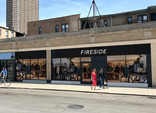
Property Record
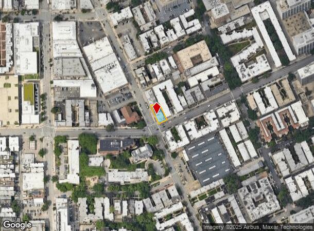
3601 N Broadway St, Chicago, IL 60613
NEARBY LISTINGS FOR SALE OR LEASE
Property Detail
3601 N Broadway St
14-21-109-021-0000
Hundleys Subdivision
Financialbuilding
Cook
X
Illinois
17031C0409K
0.12 AC
2023
Northwest City
2024
Chicago
060900
Chicago-Naperville-Elgin, IL-IN-WI
9,290 SF
DEMOGRAPHICS near 3601 N Broadway St
1 Mile
3 Mile
5 Mile
2024 Total Population
88,661
390,009
975,808
2029 Population
86,527
378,858
944,974
Pop Growth 2024-2029
(2.41%)
(2.86%)
(3.16%)
Average Age
36
37
37
2024 Total Households
52,128
203,262
477,903
HH Growth 2024-2029
(2.64%)
(3.03%)
(3.11%)
Median Household Inc
$86,753
$95,357
$91,754
Avg Household Size
1.70
1.90
2.00
2024 Avg HH Vehicles
1.00
1.00
1.00
Median Home Value
$403,810
$499,093
$460,576
Median Year Built
1962
1957
1959
Nearby Places
Map Layers
Map Styles
 Street
 Aerial
- Restaurants
- Banks
- Shops
- Fitness
- Groceries
PUBLIC TRANSPORTATION
TRANSIT/SUBWAY
Addison Station (Red Line) (Red Line - Chicago Transit Authority "L" Trains (The "L"))
DRIVE
WALK
Distance
Addison Station (Red Line) (Red Line - Chicago Transit Authority "L" Trains (The "L"))
1 min
7 min
0.4 mi
Sheridan Station (Red Line - Chicago Transit Authority "L" Trains (The "L"))
DRIVE
WALK
Distance
Sheridan Station (Red Line - Chicago Transit Authority "L" Trains (The "L"))
2 min
14 min
0.7 mi
Belmont Station (Brown, Purple, Red Lines) (Brown Line - Chicago Transit Authority "L" Trains (The "L"), Purple Line - Chicago Transit Authority "L" Trains (The "L"), Red Line - Chicago Transit Authority "L" Trains (The "L"))
DRIVE
WALK
Distance
Belmont Station (Brown, Purple, Red Lines) (Brown Line - Chicago Transit Authority "L" Trains (The "L"), Purple Line - Chicago Transit Authority "L" Trains (The "L"), Red Line - Chicago Transit Authority "L" Trains (The "L"))
2 min
17 min
0.9 mi
COMMUTER RAIL
Ravenswood Station (Union Pacific North Line - Northeast Illinois Regional Commuter Railroad (Metra))
DRIVE
WALK
Distance
Ravenswood Station (Union Pacific North Line - Northeast Illinois Regional Commuter Railroad (Metra))
6 min
2.7 mi
Clybourn Station (Union Pacific North Line - Northeast Illinois Regional Commuter Railroad (Metra), Union Pacific Northwest Line - Northeast Illinois Regional Commuter Railroad (Metra))
DRIVE
WALK
Distance
Clybourn Station (Union Pacific North Line - Northeast Illinois Regional Commuter Railroad (Metra), Union Pacific Northwest Line - Northeast Illinois Regional Commuter Railroad (Metra))
7 min
3.4 mi
AIRPORT
Chicago O'Hare International
DRIVE
WALK
Distance
Chicago O'Hare International
24 min
14.7 mi
Chicago Midway International
DRIVE
WALK
Distance
Chicago Midway International
27 min
17.2 mi
SALE & LEASE HISTORY
LISTING DATE
SALE/LEASE

Oct 11, 2016
For Lease
May 18, 2017
For Lease
May 03, 2019
For Lease
Jan 08, 2020
For Lease
Nearby Properties
Address
Land Use
TOTAL SIZE
Lot Size
Zoning
Address
Land Use
TOTAL SIZE
Lot Size
Zoning
1.09 AC
B1-3
Address
Land Use
TOTAL SIZE
Lot Size
Zoning
228,018 SF
8.72 AC
PD 958
Address
Land Use
TOTAL SIZE
Lot Size
Zoning
222,240 SF
2.45 AC
PD 1439
Address
Land Use
TOTAL SIZE
Lot Size
Zoning
266,248 SF
Address
Land Use
TOTAL SIZE
Lot Size
Zoning
1,426,524 SF
2.15 AC
RM-6.5
Address
Land Use
TOTAL SIZE
Lot Size
Zoning
0.96 AC
PD 958
Address
Land Use
TOTAL SIZE
Lot Size
Zoning
24,296 SF
0.25 AC
RM-5
Address
Land Use
TOTAL SIZE
Lot Size
Zoning
16.93 AC
POS-1,PD 1
Address
Land Use
TOTAL SIZE
Lot Size
Zoning
19,500 SF
12.06 AC
PD 367
Address
Land Use
TOTAL SIZE
Lot Size
Zoning
0.21 AC
B1-3
Address
Land Use
TOTAL SIZE
Lot Size
Zoning
376,302 SF
PD 1019
Address
Land Use
TOTAL SIZE
Lot Size
Zoning
434,320 SF
1.16 AC
C3-5
Address
Land Use
TOTAL SIZE
Lot Size
Zoning
268,778 SF
0.59 AC
RM-6.5
Address
Land Use
TOTAL SIZE
Lot Size
Zoning
301,100 SF
2.20 AC
PD 37
Address
Land Use
TOTAL SIZE
Lot Size
Zoning
1 AC
RS-3
Address
Land Use
TOTAL SIZE
Lot Size
Zoning
0.64 AC
PD 158
Address
Land Use
TOTAL SIZE
Lot Size
Zoning
0.81 AC
PD 158
Address
Land Use
TOTAL SIZE
Lot Size
Zoning
1.32 AC
PD 1398
Address
Land Use
TOTAL SIZE
Lot Size
Zoning
82,000 SF
9.68 AC
PD 437
Address
Land Use
TOTAL SIZE
Lot Size
Zoning
277,195 SF
1.78 AC
PD 1094
Address
Land Use
TOTAL SIZE
Lot Size
Zoning
255,926 SF
0.73 AC
RM-6.5
Address
Land Use
TOTAL SIZE
Lot Size
Zoning
190,011 SF
5.90 AC
PD 353
Address
Land Use
TOTAL SIZE
Lot Size
Zoning
147,835 SF
1.03 AC
PD 37
Address
Land Use
TOTAL SIZE
Lot Size
Zoning
170,538 SF
0.76 AC
PD 112
Address
Land Use
TOTAL SIZE
Lot Size
Zoning
331,294 SF
13.03 AC
PD 439
Address
Land Use
TOTAL SIZE
Lot Size
Zoning
346,332 SF
0.67 AC
RM-6.5
Address
Land Use
TOTAL SIZE
Lot Size
Zoning
311,556 SF
PD 1420
Address
Land Use
TOTAL SIZE
Lot Size
Zoning
2.25 AC
PD 612
Address
Land Use
TOTAL SIZE
Lot Size
Zoning
162,700 SF
0.64 AC
PD 50
Address
Land Use
TOTAL SIZE
Lot Size
Zoning
55,476 SF
6.16 AC
PD 619
The World's #1 Commercial Real Estate Marketplace
Connect with us
© 2025 CoStar Group
The information above has been obtained from sources believed reliable. While we do not doubt its accuracy we have not verified it and make no guarantee, warranty or representation about it. It is your responsibility to independently confirm its accuracy and completeness. Any projections, opinions, assumptions, or estimates used are for example only and do not represent the current or future performance of the property. The value of this transaction to you depends on tax and other factors which should be evaluated by your tax, financial, and legal advisors. You and your advisors should conduct a careful, independent investigation of the property to determine to your satisfaction the suitability of the property for your needs.