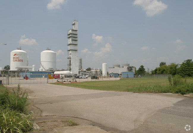
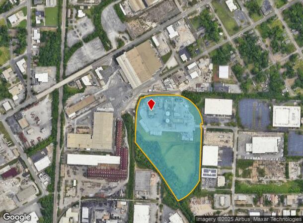
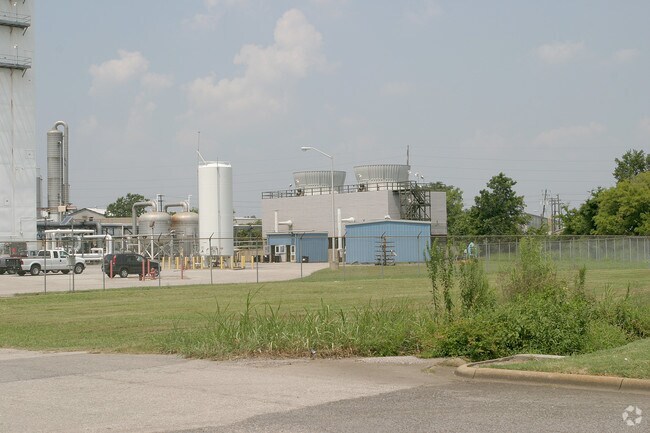
Property Record
3601 7Th Ave N, Birmingham, AL 35222
NEARBY LISTINGS FOR SALE OR LEASE
Property Detail
3601 7Th Ave N
Birmingham-Hoover, AL
Airport Hwy Res Lot 1 Pk1
23-00-30-1-002-001.008
PT OF LOT 1-A AIRPORT HWY PARK RESURVEY #1 PB 177 PG 29 DESC AS: WESTERN MOST COR SD LOT TH NLY ALG E/SIDE OF RR 512.9 FT TH ELY 48.4 FT TH N 12.3 FT TH ELY 440.9 FT TH SE 529.3 FT TH W 25 FT TH S 60 FT TH E 14 FT TH S 682.9 FT TH SW 113.8 FT TH SWLY
Chemical
Jefferson
AE
Alabama
01073C0391H
1-a,t
2023
20.10 AC
2024
Eastside
002401
Birmingham
13,072 SF
DEMOGRAPHICS near 3601 7Th Ave N
1 Mile
3 Mile
5 Mile
2024 Total Population
3,469
67,235
159,624
2029 Population
3,485
67,408
159,455
Pop Growth 2024-2029
+ 0.46%
+ 0.26%
(0.11%)
Average Age
35
38
38
2024 Total Households
1,317
30,752
68,631
HH Growth 2024-2029
+ 0.99%
+ 0.33%
(0.06%)
Median Household Inc
$19,374
$41,546
$45,166
Avg Household Size
2.40
1.90
2.10
2024 Avg HH Vehicles
1.00
1.00
2.00
Median Home Value
$70,674
$234,497
$230,919
Median Year Built
1966
1963
1964
Nearby Places
Map Layers
Map Styles
 Street
 Aerial
- Restaurants
- Banks
- Shops
- Fitness
- Groceries
PUBLIC TRANSPORTATION
COMMUTER RAIL
Birmingham (Crescent - Amtrak)
DRIVE
WALK
Distance
Birmingham (Crescent - Amtrak)
7 min
2.5 mi
AIRPORT
Birmingham-Shuttlesworth International
DRIVE
WALK
Distance
Birmingham-Shuttlesworth International
8 min
3.5 mi
Freight Ports
Port of Mobile
DRIVE
WALK
Distance
Port of Mobile
286 min
259.2 mi
Nearby Properties
Address
Land Use
TOTAL SIZE
Lot Size
Zoning
Address
Land Use
TOTAL SIZE
Lot Size
Zoning
296,284 SF
12 AC
OI
Address
Land Use
TOTAL SIZE
Lot Size
Zoning
305,826 SF
3.68 AC
B4
Address
Land Use
TOTAL SIZE
Lot Size
Zoning
189,447 SF
3.67 AC
B4
Address
Land Use
TOTAL SIZE
Lot Size
Zoning
145,865 SF
142 AC
M1-M
Address
Land Use
TOTAL SIZE
Lot Size
Zoning
224,049 SF
4.33 AC
M1
Address
Land Use
TOTAL SIZE
Lot Size
Zoning
239,334 SF
4.42 AC
B6
Address
Land Use
TOTAL SIZE
Lot Size
Zoning
230,441 SF
10.22 AC
M1
Address
Land Use
TOTAL SIZE
Lot Size
Zoning
183,862 SF
9.66 AC
B4
Address
Land Use
TOTAL SIZE
Lot Size
Zoning
334,463 SF
1.92 AC
B4
Address
Land Use
TOTAL SIZE
Lot Size
Zoning
94,958 SF
4.47 AC
M1
Address
Land Use
TOTAL SIZE
Lot Size
Zoning
106,144 SF
1.09 AC
B4
Address
Land Use
TOTAL SIZE
Lot Size
Zoning
57,066 SF
0.80 AC
B4
Address
Land Use
TOTAL SIZE
Lot Size
Zoning
298,966 SF
73 AC
M1
Address
Land Use
TOTAL SIZE
Lot Size
Zoning
79,458 SF
1.37 AC
B4
Address
Land Use
TOTAL SIZE
Lot Size
Zoning
46,161 SF
1.38 AC
M1-B
Address
Land Use
TOTAL SIZE
Lot Size
Zoning
95,993 SF
3.67 AC
M1
Address
Land Use
TOTAL SIZE
Lot Size
Zoning
229,669 SF
2.75 AC
B4
Address
Land Use
TOTAL SIZE
Lot Size
Zoning
109,411 SF
2.77 AC
B4
Address
Land Use
TOTAL SIZE
Lot Size
Zoning
1.66 AC
M1-B
Address
Land Use
TOTAL SIZE
Lot Size
Zoning
1,666 SF
1.69 AC
M1
Address
Land Use
TOTAL SIZE
Lot Size
Zoning
1.54 AC
B4
Address
Land Use
TOTAL SIZE
Lot Size
Zoning
29,136 SF
1.58 AC
B4
Address
Land Use
TOTAL SIZE
Lot Size
Zoning
37,733 SF
0.84 AC
B-4
Address
Land Use
TOTAL SIZE
Lot Size
Zoning
109,819 SF
2.91 AC
M2
Address
Land Use
TOTAL SIZE
Lot Size
Zoning
37,640 SF
1.76 AC
B4
Address
Land Use
TOTAL SIZE
Lot Size
Zoning
111,309 SF
1.29 AC
B-4
Address
Land Use
TOTAL SIZE
Lot Size
Zoning
32,948 SF
0.48 AC
B3
Address
Land Use
TOTAL SIZE
Lot Size
Zoning
30,453 SF
0.44 AC
B2
Address
Land Use
TOTAL SIZE
Lot Size
Zoning
120,768 SF
1.75 AC
B4
Address
Land Use
TOTAL SIZE
Lot Size
Zoning
156,986 SF
1.29 AC
M1
The World's #1 Commercial Real Estate Marketplace
Connect with us
© 2026 CoStar Group
The information above has been obtained from sources believed reliable. While we do not doubt its accuracy we have not verified it and make no guarantee, warranty or representation about it. It is your responsibility to independently confirm its accuracy and completeness. Any projections, opinions, assumptions, or estimates used are for example only and do not represent the current or future performance of the property. The value of this transaction to you depends on tax and other factors which should be evaluated by your tax, financial, and legal advisors. You and your advisors should conduct a careful, independent investigation of the property to determine to your satisfaction the suitability of the property for your needs.