Property Record
3601 Andrews Hwy, Midland, TX 79703
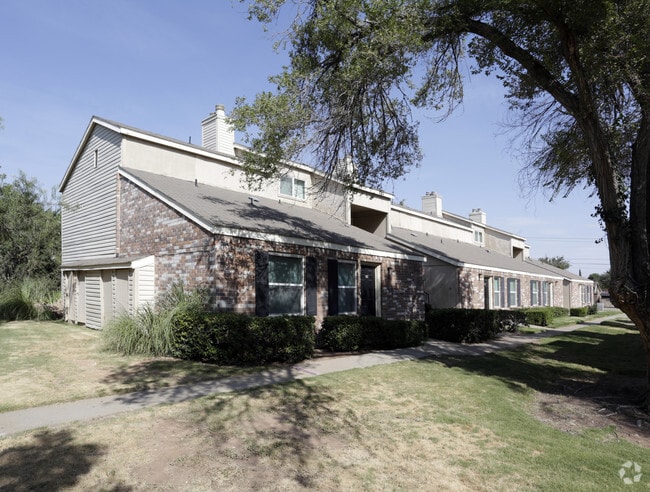


Property Detail
3601 Andrews Hwy
Midland, TX
ACRES: 8.729 BLK: 004 LOT: 056 ADDN: SUPERIOR
R000047-373
Midland
Multifamilydwelling
Texas
MF1
56
2025
8.73 AC
2025
Midland & Odessa
000402
Other Market Areas
137,457 SF
NEARBY LISTINGS FOR SALE OR LEASE
-
-
View all Midland listings for sale on LoopNet.com
DEMOGRAPHICS near 3601 Andrews Hwy
1 mile
3 mile
5 mile
2025 Total Population
14,486
92,936
144,852
2030 Population
15,844
102,041
159,761
Pop Growth 2025-2030
+ 9.37%
+ 9.80%
+ 10.29%
Average Age
36
36
35
2025 Total Households
5,590
35,559
53,215
HH Growth 2025-2030
+ 10.59%
+ 11.07%
+ 11.52%
Median Household Inc
$70,681
$90,090
$89,456
Avg Household Size
2.50
2.60
2.60
2025 Avg HH Vehicles
2.00
2.00
2.00
Median Home Value
$267,272
$317,411
$310,583
Median Year Built
1974
1982
1985
Nearby Places
Map Layers
Map Styles
 Street
 Aerial
Transit
 Traffic
 Biking
Places
Listings with unknown addresses are not visible on the map
- Restaurants
- Banks
- Shops
- Fitness
- Groceries
PUBLIC TRANSPORTATION
AIRPORT
Midland International Air And Space Port
Drive
Walk
Distance
Midland International Air And Space Port
16 min
9.7 mi
Freight Ports
Calhoun Port
Drive
Walk
Distance
Calhoun Port
529 min
474.7 mi
Nearby Properties
Address
Land Use
TOTAL SIZE
Lot Size
Zoning
Address
Land Use
TOTAL SIZE
Lot Size
Zoning
322,000 SF
24.88 AC
Address
Land Use
TOTAL SIZE
Lot Size
Zoning
25,575 SF
8.90 AC
Address
Land Use
TOTAL SIZE
Lot Size
Zoning
56,157 SF
18.19 AC
PDOC
Address
Land Use
TOTAL SIZE
Lot Size
Zoning
15,052 SF
4.68 AC
C1
Address
Land Use
TOTAL SIZE
Lot Size
Zoning
2,339 SF
17.14 AC
Address
Land Use
TOTAL SIZE
Lot Size
Zoning
2,453 SF
13.68 AC
Address
Land Use
TOTAL SIZE
Lot Size
Zoning
1,173 SF
14.05 AC
PDHD
Address
Land Use
TOTAL SIZE
Lot Size
Zoning
24,000 SF
11.87 AC
Address
Land Use
TOTAL SIZE
Lot Size
Zoning
2,196 SF
15.11 AC
PDHD
Address
Land Use
TOTAL SIZE
Lot Size
Zoning
7,793 SF
15.51 AC
Address
Land Use
TOTAL SIZE
Lot Size
Zoning
262,640 SF
13.71 AC
MF1
Address
Land Use
TOTAL SIZE
Lot Size
Zoning
28,750 SF
10.11 AC
Address
Land Use
TOTAL SIZE
Lot Size
Zoning
8,004 SF
3.58 AC
C1
Address
Land Use
TOTAL SIZE
Lot Size
Zoning
676 SF
11.40 AC
Address
Land Use
TOTAL SIZE
Lot Size
Zoning
7,200 SF
17.74 AC
MF1
Address
Land Use
TOTAL SIZE
Lot Size
Zoning
15,000 SF
39.46 AC
PDHD
Address
Land Use
TOTAL SIZE
Lot Size
Zoning
600 SF
12.45 AC
MF1
Address
Land Use
TOTAL SIZE
Lot Size
Zoning
12,916 SF
0.71 AC
MF1
Address
Land Use
TOTAL SIZE
Lot Size
Zoning
44,784 SF
11.97 AC
MF1
Address
Land Use
TOTAL SIZE
Lot Size
Zoning
12,960 SF
15.93 AC
MF1
Address
Land Use
TOTAL SIZE
Lot Size
Zoning
2,049 SF
8.79 AC
MF1
Address
Land Use
TOTAL SIZE
Lot Size
Zoning
1,725 SF
11.98 AC
MF1
Address
Land Use
TOTAL SIZE
Lot Size
Zoning
109,881 SF
10.38 AC
MF1
Address
Land Use
TOTAL SIZE
Lot Size
Zoning
5,884 SF
22.97 AC
PDSC
Address
Land Use
TOTAL SIZE
Lot Size
Zoning
7,200 SF
10.68 AC
MF1
Address
Land Use
TOTAL SIZE
Lot Size
Zoning
209,680 SF
6.16 AC
Address
Land Use
TOTAL SIZE
Lot Size
Zoning
7,008 SF
0.96 AC
C1
Address
Land Use
TOTAL SIZE
Lot Size
Zoning
1,369 SF
8.69 AC
MF1
Address
Land Use
TOTAL SIZE
Lot Size
Zoning
1,678 SF
9.11 AC
MF1
Address
Land Use
TOTAL SIZE
Lot Size
Zoning
1,980 SF
10.25 AC
MF1
The World's #1 Commercial Real Estate Marketplace
Connect with us
© 2026 CoStar Group
The information above has been obtained from sources believed reliable. While we do not doubt its accuracy we have not verified it and make no guarantee, warranty or representation about it. It is your responsibility to independently confirm its accuracy and completeness. Any projections, opinions, assumptions, or estimates used are for example only and do not represent the current or future performance of the property. The value of this transaction to you depends on tax and other factors which should be evaluated by your tax, financial, and legal advisors. You and your advisors should conduct a careful, independent investigation of the property to determine to your satisfaction the suitability of the property for your needs.