Property Record
3601 Dave Ward Dr, Conway, AR 72034
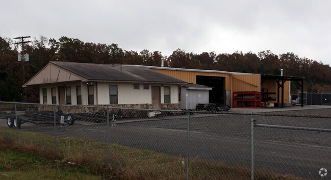


Property Detail
3601 Dave Ward Dr
Little Rock-North Little Rock-Conway, AR
PT LOT 30-32 SHERWOOD ESTATES TUPELO 28
441-00029-001C
FAULKNER
Lightindustrial
Arkansas
B and X Area of moderate flood hazard, usually the area between the limits of the 100-year and 500-year floods.
30-32
2025
12.20 AC
2025
Faulkner County
031003
Little Rock/N Little Rock
94,673 SF
NEARBY LISTINGS FOR SALE OR LEASE
DEMOGRAPHICS near 3601 Dave Ward Dr
1 mile
3 mile
5 mile
2025 Total Population
3,256
47,544
65,419
2030 Population
3,460
49,862
68,775
Pop Growth 2025-2030
+ 6.27%
+ 4.88%
+ 5.13%
Average Age
39
36
36
2025 Total Households
1,260
18,780
25,935
HH Growth 2025-2030
+ 6.59%
+ 5.31%
+ 5.50%
Median Household Inc
$63,660
$66,524
$64,473
Avg Household Size
2.50
2.30
2.30
2025 Avg HH Vehicles
2.00
2.00
2.00
Median Home Value
$248,245
$286,750
$270,898
Median Year Built
1996
1998
1997
Nearby Places
Map Layers
Map Styles
 Street
 Aerial
Layers
 Traffic
 Biking
Places
Listings with unknown addresses are not visible on the map
- Restaurants
- Banks
- Shops
- Fitness
- Groceries
Nearby Properties
Address
Land Use
TOTAL SIZE
Lot Size
Zoning
Address
Land Use
TOTAL SIZE
Lot Size
Zoning
94,854 SF
10.40 AC
Address
Land Use
TOTAL SIZE
Lot Size
Zoning
89,037 SF
11.30 AC
Address
Land Use
TOTAL SIZE
Lot Size
Zoning
26,928 SF
2.37 AC
Address
Land Use
TOTAL SIZE
Lot Size
Zoning
26,608 SF
17.40 AC
Address
Land Use
TOTAL SIZE
Lot Size
Zoning
24,757 SF
27.65 AC
Address
Land Use
TOTAL SIZE
Lot Size
Zoning
21,204 SF
65.01 AC
Address
Land Use
TOTAL SIZE
Lot Size
Zoning
21,664 SF
13.85 AC
Address
Land Use
TOTAL SIZE
Lot Size
Zoning
77,129 SF
12.84 AC
Address
Land Use
TOTAL SIZE
Lot Size
Zoning
21,532 SF
13.21 AC
Address
Land Use
TOTAL SIZE
Lot Size
Zoning
30,312 SF
7.24 AC
Address
Land Use
TOTAL SIZE
Lot Size
Zoning
32,900 SF
21.54 AC
Address
Land Use
TOTAL SIZE
Lot Size
Zoning
98,915 SF
2.77 AC
Address
Land Use
TOTAL SIZE
Lot Size
Zoning
73,124 SF
11.60 AC
Address
Land Use
TOTAL SIZE
Lot Size
Zoning
31,584 SF
8.60 AC
Address
Land Use
TOTAL SIZE
Lot Size
Zoning
12,419 SF
1.56 AC
Address
Land Use
TOTAL SIZE
Lot Size
Zoning
154,053 SF
15.07 AC
Address
Land Use
TOTAL SIZE
Lot Size
Zoning
21,204 SF
25.71 AC
Address
Land Use
TOTAL SIZE
Lot Size
Zoning
126,911 SF
10.19 AC
Address
Land Use
TOTAL SIZE
Lot Size
Zoning
17,444 SF
8.01 AC
Address
Land Use
TOTAL SIZE
Lot Size
Zoning
31,520 SF
12.66 AC
Address
Land Use
TOTAL SIZE
Lot Size
Zoning
8,956 SF
7.63 AC
Address
Land Use
TOTAL SIZE
Lot Size
Zoning
40,806 SF
5.13 AC
Address
Land Use
TOTAL SIZE
Lot Size
Zoning
43,180 SF
4.33 AC
Address
Land Use
TOTAL SIZE
Lot Size
Zoning
52,915 SF
7.86 AC
Address
Land Use
TOTAL SIZE
Lot Size
Zoning
17,591 SF
6.64 AC
Address
Land Use
TOTAL SIZE
Lot Size
Zoning
51,008 SF
3.68 AC
Address
Land Use
TOTAL SIZE
Lot Size
Zoning
9,840 SF
6.35 AC
Address
Land Use
TOTAL SIZE
Lot Size
Zoning
10,839 SF
1.52 AC
Address
Land Use
TOTAL SIZE
Lot Size
Zoning
77,520 SF
10 AC
Address
Land Use
TOTAL SIZE
Lot Size
Zoning
65,670 SF
2.32 AC
The World's #1 Commercial Real Estate Marketplace
Connect with us
© 2026 CoStar Group
The information above has been obtained from sources believed reliable. While we do not doubt its accuracy we have not verified it and make no guarantee, warranty or representation about it. It is your responsibility to independently confirm its accuracy and completeness. Any projections, opinions, assumptions, or estimates used are for example only and do not represent the current or future performance of the property. The value of this transaction to you depends on tax and other factors which should be evaluated by your tax, financial, and legal advisors. You and your advisors should conduct a careful, independent investigation of the property to determine to your satisfaction the suitability of the property for your needs.