Property Record
3601 E Us Route 36, Decatur, IL 62521

NEARBY LISTINGS FOR SALE OR LEASE
Property Detail
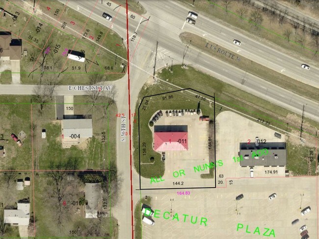
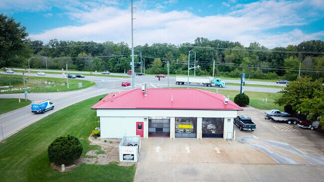
3601 E Us Route 36
Decatur, IL
Or Nunns 1St Add
09-13-20-303-011
ALL OR NUNNS 1ST ADD ~LT 1 ~96BK2636/977 ~ IRREG
Autorepair
Macon
X
Illinois
17115C0310D
1
2024
0.63 AC
2024
Springfield/Decatur
002402
Other Market Areas
DEMOGRAPHICS near 3601 E Us Route 36
1 Mile
3 Mile
5 Mile
2024 Total Population
4,041
28,393
65,073
2029 Population
3,858
27,571
63,712
Pop Growth 2024-2029
(4.53%)
(2.90%)
(2.09%)
Average Age
47
42
40
2024 Total Households
1,946
12,341
28,068
HH Growth 2024-2029
(4.62%)
(2.98%)
(2.16%)
Median Household Inc
$73,483
$51,765
$43,569
Avg Household Size
2.00
2.20
2.20
2024 Avg HH Vehicles
2.00
2.00
2.00
Median Home Value
$129,542
$115,168
$98,420
Median Year Built
1967
1961
1961
Nearby Places
Map Layers
Map Styles
 Street
 Aerial
- Restaurants
- Banks
- Shops
- Fitness
- Groceries
SALE & LEASE HISTORY
LISTING DATE
SALE/LEASE

Oct 11, 2022
For Sale
May 31, 2017
For Sale
Nearby Properties
Address
Land Use
TOTAL SIZE
Lot Size
Zoning
Address
Land Use
TOTAL SIZE
Lot Size
Zoning
87.31 AC
MUNICIPAL
Address
Land Use
TOTAL SIZE
Lot Size
Zoning
68.23 AC
MUNICIPAL
Address
Land Use
TOTAL SIZE
Lot Size
Zoning
23.63 AC
MUNICIPAL
Address
Land Use
TOTAL SIZE
Lot Size
Zoning
Address
Land Use
TOTAL SIZE
Lot Size
Zoning
25.59 AC
MUNICIPAL
Address
Land Use
TOTAL SIZE
Lot Size
Zoning
54.49 AC
MUNICIPAL
Address
Land Use
TOTAL SIZE
Lot Size
Zoning
35.07 AC
MUNICIPAL
Address
Land Use
TOTAL SIZE
Lot Size
Zoning
Address
Land Use
TOTAL SIZE
Lot Size
Zoning
6.36 AC
MUNICIPAL
Address
Land Use
TOTAL SIZE
Lot Size
Zoning
2.61 AC
MUNICIPAL
Address
Land Use
TOTAL SIZE
Lot Size
Zoning
4.21 AC
MUNICIPAL
Address
Land Use
TOTAL SIZE
Lot Size
Zoning
21,555 SF
4.99 AC
MUNICIPAL
Address
Land Use
TOTAL SIZE
Lot Size
Zoning
1 AC
MUNICIPAL
Address
Land Use
TOTAL SIZE
Lot Size
Zoning
51.03 AC
MUNICIPAL
Address
Land Use
TOTAL SIZE
Lot Size
Zoning
4.64 AC
MUNICIPAL
Address
Land Use
TOTAL SIZE
Lot Size
Zoning
1.24 AC
MUNICIPAL
Address
Land Use
TOTAL SIZE
Lot Size
Zoning
6.20 AC
MUNICIPAL
Address
Land Use
TOTAL SIZE
Lot Size
Zoning
7.74 AC
MUNICIPAL
Address
Land Use
TOTAL SIZE
Lot Size
Zoning
4.05 AC
MUNICIPAL
Address
Land Use
TOTAL SIZE
Lot Size
Zoning
1.24 AC
MUNICIPAL
Address
Land Use
TOTAL SIZE
Lot Size
Zoning
6.28 AC
MUNICIPAL
Address
Land Use
TOTAL SIZE
Lot Size
Zoning
3.47 AC
MUNICIPAL
Address
Land Use
TOTAL SIZE
Lot Size
Zoning
8.22 AC
MUNICIPAL
Address
Land Use
TOTAL SIZE
Lot Size
Zoning
2.89 AC
MUNICIPAL
Address
Land Use
TOTAL SIZE
Lot Size
Zoning
56.07 AC
MUNICIPAL
Address
Land Use
TOTAL SIZE
Lot Size
Zoning
7.50 AC
MUNICIPAL
Address
Land Use
TOTAL SIZE
Lot Size
Zoning
2.21 AC
MUNICIPAL
Address
Land Use
TOTAL SIZE
Lot Size
Zoning
2.24 AC
MUNICIPAL
Address
Land Use
TOTAL SIZE
Lot Size
Zoning
48.84 AC
MUNICIPAL
Address
Land Use
TOTAL SIZE
Lot Size
Zoning
0.85 AC
MUNICIPAL
The World's #1 Commercial Real Estate Marketplace
Connect with us
© 2026 CoStar Group
The information above has been obtained from sources believed reliable. While we do not doubt its accuracy we have not verified it and make no guarantee, warranty or representation about it. It is your responsibility to independently confirm its accuracy and completeness. Any projections, opinions, assumptions, or estimates used are for example only and do not represent the current or future performance of the property. The value of this transaction to you depends on tax and other factors which should be evaluated by your tax, financial, and legal advisors. You and your advisors should conduct a careful, independent investigation of the property to determine to your satisfaction the suitability of the property for your needs.