Property Record
3601 Hazel St, Texarkana, TX 75503

Property Detail
3601 Hazel St
20300003700
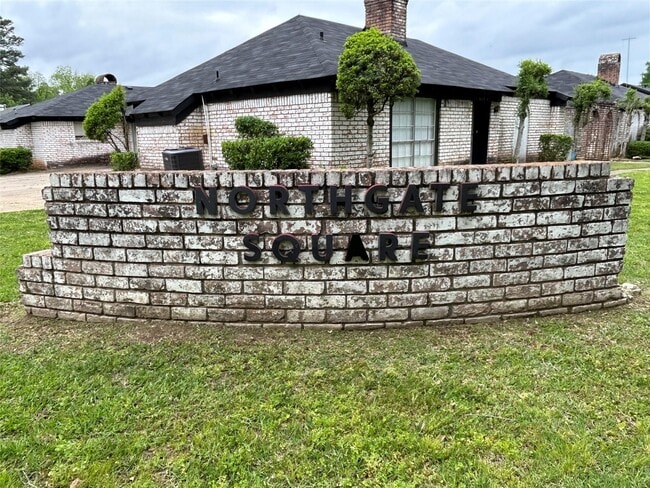
ROCHELLE HEIGHTS NORTHGATE SQUARE S17.5 PUBLIC STREET 2024-10698 11/12/24 BLK/TRACT 7 2.05 ACRES
Multifamilydwelling
BOWIE
B and X Area of moderate flood hazard, usually the area between the limits of the 100-year and 500-year floods.
Texas
2025
2.05 AC
2025
Texas East Area
010903
Other Market Areas
25,250 SF
Texarkana, TX-AR
NEARBY LISTINGS FOR SALE OR LEASE
DEMOGRAPHICS near 3601 Hazel St
1 mile
3 mile
5 mile
2025 Total Population
8,467
45,588
69,497
2030 Population
8,332
45,209
69,024
Pop Growth 2025-2030
(1.59%)
(0.83%)
(0.68%)
Average Age
39
39
39
2025 Total Households
3,481
18,319
27,937
HH Growth 2025-2030
(1.64%)
(0.87%)
(0.70%)
Median Household Inc
$44,660
$43,460
$46,508
Avg Household Size
2.30
2.30
2.30
2025 Avg HH Vehicles
2.00
2.00
2.00
Median Home Value
$110,789
$134,228
$151,063
Median Year Built
1966
1975
1979
Nearby Places
Map Layers
Map Styles
 Street
 Aerial
Layers
 Traffic
 Biking
Places
Listings with unknown addresses are not visible on the map
- Restaurants
- Banks
- Shops
- Fitness
- Groceries
PUBLIC TRANSPORTATION
COMMUTER RAIL
Texarkana Amtrak Station (Texas Eagle - Amtrak)
Drive
Walk
Distance
Texarkana Amtrak Station (Texas Eagle - Amtrak)
5 min
2.4 mi
AIRPORT
Texarkana Regional-Webb Field
Drive
Walk
Distance
Texarkana Regional-Webb Field
13 min
5.0 mi
Freight Ports
Port of Shreveport
Drive
Walk
Distance
Port of Shreveport
110 min
94.6 mi
SALE & LEASE HISTORY
LISTING DATE
SALE/LEASE

May 28, 2024
For Sale
Nearby Properties
Address
Land Use
TOTAL SIZE
Lot Size
Zoning
Address
Land Use
TOTAL SIZE
Lot Size
Zoning
37.76 AC
Address
Land Use
TOTAL SIZE
Lot Size
Zoning
594,669 SF
26.19 AC
Address
Land Use
TOTAL SIZE
Lot Size
Zoning
22.35 AC
Address
Land Use
TOTAL SIZE
Lot Size
Zoning
Address
Land Use
TOTAL SIZE
Lot Size
Zoning
162,169 SF
19.18 AC
Address
Land Use
TOTAL SIZE
Lot Size
Zoning
133,136 SF
5.80 AC
Address
Land Use
TOTAL SIZE
Lot Size
Zoning
11.66 AC
Address
Land Use
TOTAL SIZE
Lot Size
Zoning
3,642 SF
24.74 AC
Address
Land Use
TOTAL SIZE
Lot Size
Zoning
11,320 SF
142 AC
Address
Land Use
TOTAL SIZE
Lot Size
Zoning
97,914 SF
3.01 AC
Address
Land Use
TOTAL SIZE
Lot Size
Zoning
2.07 AC
Address
Land Use
TOTAL SIZE
Lot Size
Zoning
73,675 SF
4.44 AC
Address
Land Use
TOTAL SIZE
Lot Size
Zoning
Address
Land Use
TOTAL SIZE
Lot Size
Zoning
8.19 AC
Address
Land Use
TOTAL SIZE
Lot Size
Zoning
533,299 SF
50.60 AC
Address
Land Use
TOTAL SIZE
Lot Size
Zoning
100,327 SF
Address
Land Use
TOTAL SIZE
Lot Size
Zoning
51,587 SF
6.44 AC
Address
Land Use
TOTAL SIZE
Lot Size
Zoning
166,777 SF
9 AC
Address
Land Use
TOTAL SIZE
Lot Size
Zoning
87,452 SF
2.32 AC
Address
Land Use
TOTAL SIZE
Lot Size
Zoning
32.42 AC
Address
Land Use
TOTAL SIZE
Lot Size
Zoning
82,125 SF
13.71 AC
Address
Land Use
TOTAL SIZE
Lot Size
Zoning
133,067 SF
11.20 AC
Address
Land Use
TOTAL SIZE
Lot Size
Zoning
124,978 SF
36.18 AC
Address
Land Use
TOTAL SIZE
Lot Size
Zoning
18.64 AC
Address
Land Use
TOTAL SIZE
Lot Size
Zoning
51,049 SF
1.78 AC
Address
Land Use
TOTAL SIZE
Lot Size
Zoning
165,001 SF
26.11 AC
Address
Land Use
TOTAL SIZE
Lot Size
Zoning
109,855 SF
6.24 AC
Address
Land Use
TOTAL SIZE
Lot Size
Zoning
18,105 SF
2.50 AC
Address
Land Use
TOTAL SIZE
Lot Size
Zoning
175,650 SF
15.56 AC
Address
Land Use
TOTAL SIZE
Lot Size
Zoning
116,386 SF
8.93 AC
The World's #1 Commercial Real Estate Marketplace
Connect with us
© 2026 CoStar Group
The information above has been obtained from sources believed reliable. While we do not doubt its accuracy we have not verified it and make no guarantee, warranty or representation about it. It is your responsibility to independently confirm its accuracy and completeness. Any projections, opinions, assumptions, or estimates used are for example only and do not represent the current or future performance of the property. The value of this transaction to you depends on tax and other factors which should be evaluated by your tax, financial, and legal advisors. You and your advisors should conduct a careful, independent investigation of the property to determine to your satisfaction the suitability of the property for your needs.