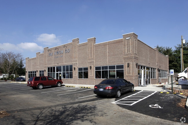
Property Record
3601 Palomar Centre Dr, Lexington, KY 40513

Property Detail
3601 Palomar Centre Dr
38173960
M-734 CHARLSEY Y SCHROYER PROPERTY LOT 2B; BOOK: 2613 PAGE: 596
Gymhealthspa
Fayette
B-1
Kentucky
B and X Area of moderate flood hazard, usually the area between the limits of the 100-year and 500-year floods.
2b
2025
0.57 AC
2025
West Lexington/Fayette
004208
Lexington/Fayette
6,175 SF
Lexington-Fayette, KY
NEARBY LISTINGS FOR SALE OR LEASE
DEMOGRAPHICS near 3601 Palomar Centre Dr
1 mile
3 mile
5 mile
2025 Total Population
10,514
65,509
161,988
2030 Population
10,791
67,277
167,126
Pop Growth 2025-2030
+ 2.63%
+ 2.70%
+ 3.17%
Average Age
45
42
38
2025 Total Households
4,255
27,617
68,663
HH Growth 2025-2030
+ 2.80%
+ 2.89%
+ 3.47%
Median Household Inc
$123,433
$90,632
$66,731
Avg Household Size
2.40
2.30
2.20
2025 Avg HH Vehicles
2.00
2.00
2.00
Median Home Value
$383,121
$326,779
$332,139
Median Year Built
1990
1982
1980
Nearby Places
Map Layers
Map Styles
 Street
 Aerial
Layers
 Traffic
 Biking
Places
Listings with unknown addresses are not visible on the map
- Restaurants
- Banks
- Shops
- Fitness
- Groceries
PUBLIC TRANSPORTATION
AIRPORT
Blue Grass
Drive
Walk
Distance
Blue Grass
13 min
6.5 mi
Nearby Properties
Address
Land Use
TOTAL SIZE
Lot Size
Zoning
Address
Land Use
TOTAL SIZE
Lot Size
Zoning
318,370 SF
17.79 AC
B-6P
Address
Land Use
TOTAL SIZE
Lot Size
Zoning
292,730 SF
3.18 AC
R-1C
Address
Land Use
TOTAL SIZE
Lot Size
Zoning
648.54 AC
A-R
Address
Land Use
TOTAL SIZE
Lot Size
Zoning
4,299 SF
18.43 AC
R-4
Address
Land Use
TOTAL SIZE
Lot Size
Zoning
263,090 SF
37.66 AC
A-U
Address
Land Use
TOTAL SIZE
Lot Size
Zoning
8,001 SF
32.59 AC
MU-3
Address
Land Use
TOTAL SIZE
Lot Size
Zoning
144,866 SF
14.83 AC
B-6P
Address
Land Use
TOTAL SIZE
Lot Size
Zoning
238,393 SF
9.83 AC
B-6P
Address
Land Use
TOTAL SIZE
Lot Size
Zoning
41,040 SF
14.77 AC
R-4
Address
Land Use
TOTAL SIZE
Lot Size
Zoning
2,968 SF
14.26 AC
R-3
Address
Land Use
TOTAL SIZE
Lot Size
Zoning
137,905 SF
23.79 AC
B-6P
Address
Land Use
TOTAL SIZE
Lot Size
Zoning
97,729 SF
4.22 AC
P-1
Address
Land Use
TOTAL SIZE
Lot Size
Zoning
10.41 AC
R-3
Address
Land Use
TOTAL SIZE
Lot Size
Zoning
14,292 SF
11.32 AC
R-4
Address
Land Use
TOTAL SIZE
Lot Size
Zoning
23,042 SF
8.90 AC
R-4
Address
Land Use
TOTAL SIZE
Lot Size
Zoning
123,221 SF
17.32 AC
R-1B
Address
Land Use
TOTAL SIZE
Lot Size
Zoning
33,996 SF
2 AC
Address
Land Use
TOTAL SIZE
Lot Size
Zoning
4,214 SF
741.62 AC
A-R
Address
Land Use
TOTAL SIZE
Lot Size
Zoning
222,168 SF
26.49 AC
B-6P
Address
Land Use
TOTAL SIZE
Lot Size
Zoning
160,800 SF
74.22 AC
R-1C
Address
Land Use
TOTAL SIZE
Lot Size
Zoning
178,160 SF
14.62 AC
R-3
Address
Land Use
TOTAL SIZE
Lot Size
Zoning
156,350 SF
18.83 AC
B-6P
Address
Land Use
TOTAL SIZE
Lot Size
Zoning
219,320 SF
8.35 AC
R-4
Address
Land Use
TOTAL SIZE
Lot Size
Zoning
94,930 SF
15.03 AC
R-1D
Address
Land Use
TOTAL SIZE
Lot Size
Zoning
88,216 SF
15 AC
R-1C
Address
Land Use
TOTAL SIZE
Lot Size
Zoning
85,491 SF
8 AC
R-1D
Address
Land Use
TOTAL SIZE
Lot Size
Zoning
236,150 SF
17.83 AC
R-1D
Address
Land Use
TOTAL SIZE
Lot Size
Zoning
145,547 SF
12.75 AC
R-4
Address
Land Use
TOTAL SIZE
Lot Size
Zoning
8,933 SF
4.98 AC
P-1
Address
Land Use
TOTAL SIZE
Lot Size
Zoning
118,794 SF
16.05 AC
B-6P
The World's #1 Commercial Real Estate Marketplace
Connect with us
© 2026 CoStar Group
The information above has been obtained from sources believed reliable. While we do not doubt its accuracy we have not verified it and make no guarantee, warranty or representation about it. It is your responsibility to independently confirm its accuracy and completeness. Any projections, opinions, assumptions, or estimates used are for example only and do not represent the current or future performance of the property. The value of this transaction to you depends on tax and other factors which should be evaluated by your tax, financial, and legal advisors. You and your advisors should conduct a careful, independent investigation of the property to determine to your satisfaction the suitability of the property for your needs.