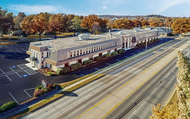
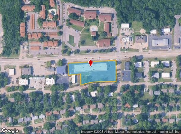
Property Record
3601 Sw 29Th St, Topeka, KS 66614

Current Lease Availabilities
NEARBY LISTINGS FOR SALE OR LEASE
Property Detail
3601 Sw 29Th St
Topeka, KS
Prairie Vista Blk 10-14
146-14-0-20-02-001-000
PRAIRIE VISTA BLK 10-14 , BLOCK 13 , LOT 1 + , LTS 1, 2, 3, 4, 16, 17, 18 BLK 13 SECTION 14 TOWNSHIP 12 RANGE 15
Officebuilding
Shawnee
X
Kansas
20177C0213E
1
2024
2.15 AC
2025
Topeka
001603
Kansas City
41,070 SF
DEMOGRAPHICS near 3601 Sw 29Th St
1 Mile
3 Mile
5 Mile
2024 Total Population
10,617
72,904
123,211
2029 Population
10,461
72,188
122,245
Pop Growth 2024-2029
(1.47%)
(0.98%)
(0.78%)
Average Age
40
40
40
2024 Total Households
5,045
32,267
52,309
HH Growth 2024-2029
(1.57%)
(1.08%)
(0.85%)
Median Household Inc
$48,953
$52,285
$50,875
Avg Household Size
2.00
2.10
2.20
2024 Avg HH Vehicles
2.00
2.00
2.00
Median Home Value
$123,568
$131,423
$132,978
Median Year Built
1968
1968
1969
Nearby Places
Map Layers
Map Styles
 Street
 Aerial
- Restaurants
- Banks
- Shops
- Fitness
- Groceries
PUBLIC TRANSPORTATION
COMMUTER RAIL
Topeka Amtrak Station (Southwest Chief - Amtrak)
DRIVE
WALK
Distance
Topeka Amtrak Station (Southwest Chief - Amtrak)
10 min
5.5 mi
Freight Ports
Tulsa Port Of Catoosa
DRIVE
WALK
Distance
Tulsa Port Of Catoosa
272 min
223.6 mi
Nearby Properties
Address
Land Use
TOTAL SIZE
Lot Size
Zoning
Address
Land Use
TOTAL SIZE
Lot Size
Zoning
249,598 SF
150.21 AC
U1
Address
Land Use
TOTAL SIZE
Lot Size
Zoning
513,835 SF
13.39 AC
M1
Address
Land Use
TOTAL SIZE
Lot Size
Zoning
117,839 SF
121.95 AC
R1
Address
Land Use
TOTAL SIZE
Lot Size
Zoning
336,669 SF
58.82 AC
PUD,C4
Address
Land Use
TOTAL SIZE
Lot Size
Zoning
3.31 AC
OI2
Address
Land Use
TOTAL SIZE
Lot Size
Zoning
77,776 SF
10.64 AC
PUD,M2,R1,
Address
Land Use
TOTAL SIZE
Lot Size
Zoning
80,630 SF
107.16 AC
R1
Address
Land Use
TOTAL SIZE
Lot Size
Zoning
19,120 SF
2.08 AC
R1
Address
Land Use
TOTAL SIZE
Lot Size
Zoning
43,282 SF
19.33 AC
PUD,M2
Address
Land Use
TOTAL SIZE
Lot Size
Zoning
114,523 SF
6.92 AC
OI3
Address
Land Use
TOTAL SIZE
Lot Size
Zoning
218,962 SF
49.63 AC
R1
Address
Land Use
TOTAL SIZE
Lot Size
Zoning
152,049 SF
25.61 AC
R1
Address
Land Use
TOTAL SIZE
Lot Size
Zoning
208,685 SF
38.23 AC
R1
Address
Land Use
TOTAL SIZE
Lot Size
Zoning
103,285 SF
16.99 AC
I1,PUD
Address
Land Use
TOTAL SIZE
Lot Size
Zoning
22,484 SF
75.33 AC
R1
Address
Land Use
TOTAL SIZE
Lot Size
Zoning
81,364 SF
19.52 AC
R1
Address
Land Use
TOTAL SIZE
Lot Size
Zoning
52,261 SF
4.59 AC
OI3
Address
Land Use
TOTAL SIZE
Lot Size
Zoning
53,136 SF
18.28 AC
PUD,M2
Address
Land Use
TOTAL SIZE
Lot Size
Zoning
38,087 SF
10.27 AC
PUD,M4
Address
Land Use
TOTAL SIZE
Lot Size
Zoning
44,567 SF
2.88 AC
MS1
Address
Land Use
TOTAL SIZE
Lot Size
Zoning
100,954 SF
77.35 AC
R1
Address
Land Use
TOTAL SIZE
Lot Size
Zoning
84,510 SF
5.95 AC
M2
Address
Land Use
TOTAL SIZE
Lot Size
Zoning
71,575 SF
10.93 AC
C2,C4
Address
Land Use
TOTAL SIZE
Lot Size
Zoning
15,880 SF
85.20 AC
R1
Address
Land Use
TOTAL SIZE
Lot Size
Zoning
22,194 SF
3.59 AC
M4
Address
Land Use
TOTAL SIZE
Lot Size
Zoning
156,628 SF
44.05 AC
I1
Address
Land Use
TOTAL SIZE
Lot Size
Zoning
40,321 SF
5.69 AC
I1
Address
Land Use
TOTAL SIZE
Lot Size
Zoning
44,143 SF
2.44 AC
OI2
Address
Land Use
TOTAL SIZE
Lot Size
Zoning
19,892 SF
3.51 AC
M4
Address
Land Use
TOTAL SIZE
Lot Size
Zoning
31,132 SF
111.36 AC
R1
The World's #1 Commercial Real Estate Marketplace
Connect with us
© 2025 CoStar Group
The information above has been obtained from sources believed reliable. While we do not doubt its accuracy we have not verified it and make no guarantee, warranty or representation about it. It is your responsibility to independently confirm its accuracy and completeness. Any projections, opinions, assumptions, or estimates used are for example only and do not represent the current or future performance of the property. The value of this transaction to you depends on tax and other factors which should be evaluated by your tax, financial, and legal advisors. You and your advisors should conduct a careful, independent investigation of the property to determine to your satisfaction the suitability of the property for your needs.