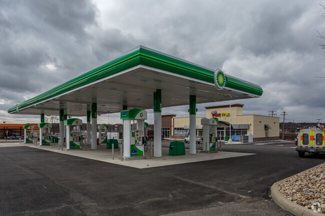
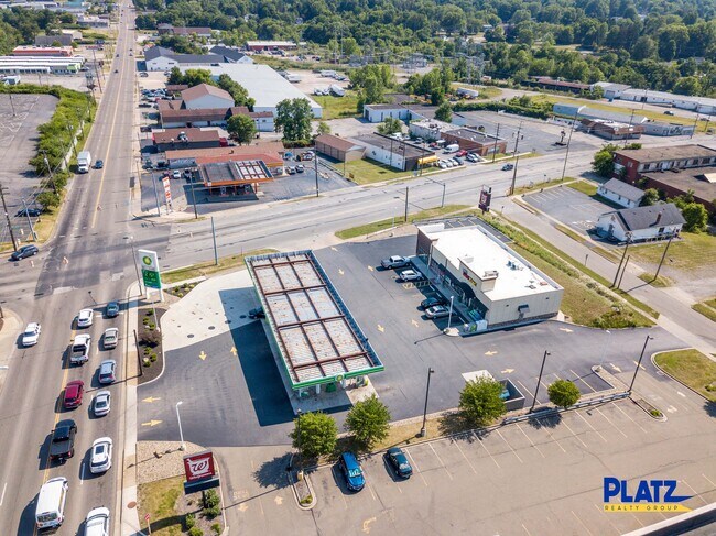
Property Record
3602 Mahoning Ave, Youngstown, OH 44515

Save to a Folder
{{folder.Name}}
{{folder.ListingIds.length}} Properties
{{folder.ListingIds.length}} Property
Create a New Folder
Property Detail
3602 Mahoning Ave
Youngstown-Warren, OH
LOT 1823 308.61 X 227.85 IRR REPLAT OF LOTS 1823-1826, 1853-1854, & 1872-1875 OF WICKLIFFE COMMERCIAL SUBDIVISION
48-023-0-134.00-0
Mahoning
Servicestationmarket
Ohio
B2
1823
2025
1.22 AC
2025
Austintown
812400
Youngstown/Warren/Boardman
4,050 SF
NEARBY LISTINGS FOR SALE OR LEASE
DEMOGRAPHICS near 3602 Mahoning Ave
1 mile
3 mile
5 mile
2025 Total Population
9,051
48,698
124,109
2030 Population
8,991
48,272
123,496
Pop Growth 2025-2030
(0.66%)
(0.87%)
(0.49%)
Average Age
40
42
41
2025 Total Households
3,941
22,001
53,030
HH Growth 2025-2030
(0.69%)
(0.99%)
(0.58%)
Median Household Inc
$42,381
$44,102
$45,141
Avg Household Size
2.20
2.10
2.20
2025 Avg HH Vehicles
2.00
2.00
2.00
Median Home Value
$76,347
$111,936
$123,114
Median Year Built
1954
1958
1958
Nearby Places
Map Layers
Map Styles
 Street
 Aerial
Layers
 Traffic
 Biking
Places
Listings with unknown addresses are not visible on the map
- Restaurants
- Banks
- Shops
- Fitness
- Groceries
SALE & LEASE HISTORY
LISTING DATE
SALE/LEASE

Jul 02, 2020
For Lease
Nearby Properties
Address
Land Use
TOTAL SIZE
Lot Size
Zoning
Address
Land Use
TOTAL SIZE
Lot Size
Zoning
981,460 SF
74.87 AC
Address
Land Use
TOTAL SIZE
Lot Size
Zoning
178,531 SF
189.16 AC
Address
Land Use
TOTAL SIZE
Lot Size
Zoning
674,524 SF
7.89 AC
Address
Land Use
TOTAL SIZE
Lot Size
Zoning
188,134 SF
12.60 AC
R1
Address
Land Use
TOTAL SIZE
Lot Size
Zoning
127,210 SF
12.43 AC
R1
Address
Land Use
TOTAL SIZE
Lot Size
Zoning
227,713 SF
15.07 AC
Address
Land Use
TOTAL SIZE
Lot Size
Zoning
122,806 SF
9.46 AC
R1
Address
Land Use
TOTAL SIZE
Lot Size
Zoning
332,914 SF
54 AC
R1
Address
Land Use
TOTAL SIZE
Lot Size
Zoning
6,207 SF
0.88 AC
Address
Land Use
TOTAL SIZE
Lot Size
Zoning
446,250 SF
43.88 AC
Address
Land Use
TOTAL SIZE
Lot Size
Zoning
172,733 SF
2.75 AC
Address
Land Use
TOTAL SIZE
Lot Size
Zoning
101,687 SF
9.93 AC
Address
Land Use
TOTAL SIZE
Lot Size
Zoning
106,598 SF
0.17 AC
Address
Land Use
TOTAL SIZE
Lot Size
Zoning
78,660 SF
22.36 AC
R3
Address
Land Use
TOTAL SIZE
Lot Size
Zoning
67,124 SF
2.50 AC
Address
Land Use
TOTAL SIZE
Lot Size
Zoning
103,976 SF
16.14 AC
PUD
Address
Land Use
TOTAL SIZE
Lot Size
Zoning
89,325 SF
28.74 AC
Address
Land Use
TOTAL SIZE
Lot Size
Zoning
123,472 SF
28.58 AC
R3
Address
Land Use
TOTAL SIZE
Lot Size
Zoning
70,544 SF
7.62 AC
B2
Address
Land Use
TOTAL SIZE
Lot Size
Zoning
63,713 SF
7.38 AC
Address
Land Use
TOTAL SIZE
Lot Size
Zoning
110,387 SF
20 AC
R3
Address
Land Use
TOTAL SIZE
Lot Size
Zoning
89,623 SF
20.45 AC
ASER
Address
Land Use
TOTAL SIZE
Lot Size
Zoning
106,276 SF
10.86 AC
Address
Land Use
TOTAL SIZE
Lot Size
Zoning
75,444 SF
0.10 AC
Address
Land Use
TOTAL SIZE
Lot Size
Zoning
95,231 SF
37.75 AC
ASER
Address
Land Use
TOTAL SIZE
Lot Size
Zoning
40,754 SF
4.14 AC
Address
Land Use
TOTAL SIZE
Lot Size
Zoning
48,901 SF
1.58 AC
Address
Land Use
TOTAL SIZE
Lot Size
Zoning
81,954 SF
15 AC
R3
Address
Land Use
TOTAL SIZE
Lot Size
Zoning
49,659 SF
19.52 AC
R3
Address
Land Use
TOTAL SIZE
Lot Size
Zoning
82,182 SF
17.19 AC
The World's #1 Commercial Real Estate Marketplace
Connect with us
© 2026 CoStar Group
The information above has been obtained from sources believed reliable. While we do not doubt its accuracy we have not verified it and make no guarantee, warranty or representation about it. It is your responsibility to independently confirm its accuracy and completeness. Any projections, opinions, assumptions, or estimates used are for example only and do not represent the current or future performance of the property. The value of this transaction to you depends on tax and other factors which should be evaluated by your tax, financial, and legal advisors. You and your advisors should conduct a careful, independent investigation of the property to determine to your satisfaction the suitability of the property for your needs.