Property Record
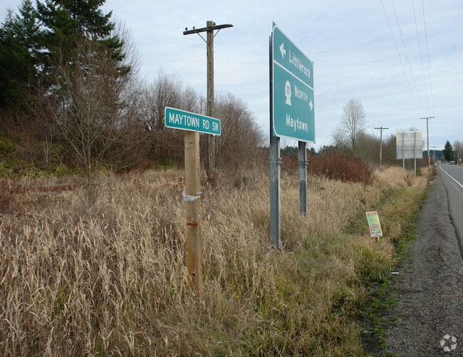
3602 Maytown Rd Sw, Olympia, WA 98512
NEARBY LISTINGS FOR SALE OR LEASE
-
-
View all Olympia listings for sale on LoopNet.com
Property Detail
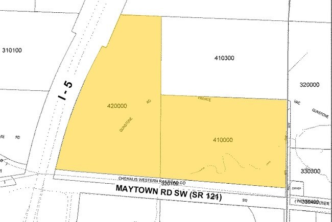
3602 Maytown Rd Sw
12605420000
SECTION 05 TOWNSHIP 16 RANGE 2W PT W2 SE4 LY ELY PSH#1 & NLY C,M,SP&P RR R/W
Miningfacilityoilgasmineralpreciousmetals
Thurston
X
Washington
53067C0300F
32.51 AC
2024
Outlying Thurston County
2024
Olympia
011822
Olympia-Lacey-Tumwater, WA
12,000 SF
DEMOGRAPHICS near 3602 Maytown Rd Sw
1 Mile
3 Mile
5 Mile
2024 Total Population
272
4,438
12,662
2029 Population
284
4,638
13,318
Pop Growth 2024-2029
+ 4.41%
+ 4.51%
+ 5.18%
Average Age
44
44
43
2024 Total Households
106
1,711
4,697
HH Growth 2024-2029
+ 3.77%
+ 4.50%
+ 5.19%
Median Household Inc
$91,477
$78,233
$88,384
Avg Household Size
2.60
2.60
2.60
2024 Avg HH Vehicles
3.00
2.00
3.00
Median Home Value
$436,486
$411,010
$439,602
Median Year Built
1991
1986
1990
Nearby Places
Map Layers
Map Styles
 Street
 Aerial
- Restaurants
- Banks
- Shops
- Fitness
- Groceries
Nearby Properties
Address
Land Use
TOTAL SIZE
Lot Size
Zoning
Address
Land Use
TOTAL SIZE
Lot Size
Zoning
43,273 SF
11.42 AC
R 1/20
Address
Land Use
TOTAL SIZE
Lot Size
Zoning
30,800 SF
15.70 AC
RRI
Address
Land Use
TOTAL SIZE
Lot Size
Zoning
496.56 AC
R 1/20
Address
Land Use
TOTAL SIZE
Lot Size
Zoning
48,920 SF
4.99 AC
RRR1/5
Address
Land Use
TOTAL SIZE
Lot Size
Zoning
34,794 SF
31.39 AC
RRI
Address
Land Use
TOTAL SIZE
Lot Size
Zoning
5,956 SF
280 AC
PP
Address
Land Use
TOTAL SIZE
Lot Size
Zoning
11,995 SF
7 AC
RRR1/5
Address
Land Use
TOTAL SIZE
Lot Size
Zoning
10,888 SF
33.28 AC
RRR1/5
Address
Land Use
TOTAL SIZE
Lot Size
Zoning
8,160 SF
49.81 AC
RRR1/5
Address
Land Use
TOTAL SIZE
Lot Size
Zoning
11,328 SF
6 AC
R 1/20
Address
Land Use
TOTAL SIZE
Lot Size
Zoning
11,192 SF
120 AC
PP
Address
Land Use
TOTAL SIZE
Lot Size
Zoning
6,639 SF
39.10 AC
RRR1/5
Address
Land Use
TOTAL SIZE
Lot Size
Zoning
6,203 SF
5.53 AC
RRR1/5
Address
Land Use
TOTAL SIZE
Lot Size
Zoning
3,200 SF
1.25 AC
RCC
Address
Land Use
TOTAL SIZE
Lot Size
Zoning
1,377 SF
37.26 AC
RRR1/5
Address
Land Use
TOTAL SIZE
Lot Size
Zoning
11,936 SF
96.54 AC
LTA
Address
Land Use
TOTAL SIZE
Lot Size
Zoning
4,601 SF
8.60 AC
RRR1/5
Address
Land Use
TOTAL SIZE
Lot Size
Zoning
5,273 SF
9.62 AC
RRR1/5
Address
Land Use
TOTAL SIZE
Lot Size
Zoning
4,644 SF
69.43 AC
LTA
Address
Land Use
TOTAL SIZE
Lot Size
Zoning
3,656 SF
25 AC
RRR1/5
Address
Land Use
TOTAL SIZE
Lot Size
Zoning
7,673 SF
79.24 AC
RRR1/5
Address
Land Use
TOTAL SIZE
Lot Size
Zoning
1,620 SF
0.36 AC
NC
Address
Land Use
TOTAL SIZE
Lot Size
Zoning
237.76 AC
R 1/20
Address
Land Use
TOTAL SIZE
Lot Size
Zoning
1,160 SF
9.40 AC
RRR1/5
Address
Land Use
TOTAL SIZE
Lot Size
Zoning
24,000 SF
4.20 AC
RRI
Address
Land Use
TOTAL SIZE
Lot Size
Zoning
40.41 AC
RRI
Address
Land Use
TOTAL SIZE
Lot Size
Zoning
1,971 SF
9.79 AC
RRR1/5
Address
Land Use
TOTAL SIZE
Lot Size
Zoning
3,716 SF
60 AC
RRR1/5
Address
Land Use
TOTAL SIZE
Lot Size
Zoning
3,488 SF
18.95 AC
RRR1/5
The World's #1 Commercial Real Estate Marketplace
Connect with us
© 2026 CoStar Group
The information above has been obtained from sources believed reliable. While we do not doubt its accuracy we have not verified it and make no guarantee, warranty or representation about it. It is your responsibility to independently confirm its accuracy and completeness. Any projections, opinions, assumptions, or estimates used are for example only and do not represent the current or future performance of the property. The value of this transaction to you depends on tax and other factors which should be evaluated by your tax, financial, and legal advisors. You and your advisors should conduct a careful, independent investigation of the property to determine to your satisfaction the suitability of the property for your needs.