Property Record
3602 N 15Th Ave, Phoenix, AZ 85015
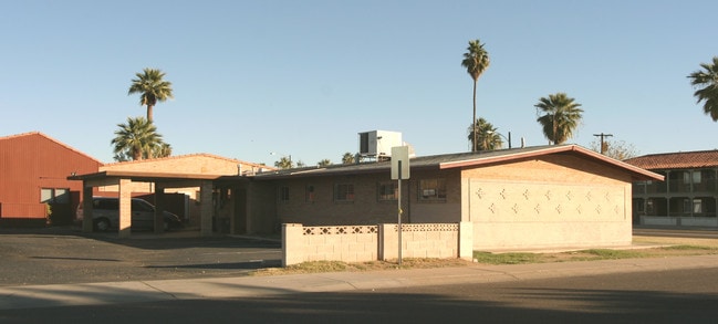

Property Detail
3602 N 15Th Ave
110-09-028B
WESTWOOD TERRACE MCR 46/16
Officebuilding
Maricopa
M-H
Arizona
C and X Area of minimal flood hazard, usually depicted on FIRMs as above the 500-year flood level.
30
2025
0.33 AC
2025
Northwest Phoenix
110400
Phoenix
1,836 SF
Phoenix-Mesa-Chandler, AZ
NEARBY LISTINGS FOR SALE OR LEASE
DEMOGRAPHICS near 3602 N 15Th Ave
1 mile
3 mile
5 mile
2025 Total Population
21,028
184,222
466,554
2030 Population
21,914
192,153
485,042
Pop Growth 2025-2030
+ 4.21%
+ 4.31%
+ 3.96%
Average Age
38
36
36
2025 Total Households
9,785
75,092
176,307
HH Growth 2025-2030
+ 4.31%
+ 4.82%
+ 4.35%
Median Household Inc
$62,803
$63,968
$64,679
Avg Household Size
2.10
2.20
2.50
2025 Avg HH Vehicles
1.00
1.00
2.00
Median Home Value
$472,350
$448,334
$421,596
Median Year Built
1964
1970
1971
Nearby Places
Map Layers
Map Styles
 Street
 Aerial
Transit
 Traffic
 Biking
Places
Listings with unknown addresses are not visible on the map
- Restaurants
- Banks
- Shops
- Fitness
- Groceries
PUBLIC TRANSPORTATION
AIRPORT
Phoenix Sky Harbor International
Drive
Walk
Distance
Phoenix Sky Harbor International
17 min
9.1 mi
Phoenix-Mesa Gateway
Drive
Walk
Distance
Phoenix-Mesa Gateway
50 min
36.3 mi
Nearby Properties
Address
Land Use
TOTAL SIZE
Lot Size
Zoning
Address
Land Use
TOTAL SIZE
Lot Size
Zoning
582,073 SF
1.45 AC
C-C
Address
Land Use
TOTAL SIZE
Lot Size
Zoning
1.85 AC
Address
Land Use
TOTAL SIZE
Lot Size
Zoning
455,443 SF
3.21 AC
C-C
Address
Land Use
TOTAL SIZE
Lot Size
Zoning
339,909 SF
3 AC
C-C
Address
Land Use
TOTAL SIZE
Lot Size
Zoning
2,568,761 SF
48.36 AC
C-C
Address
Land Use
TOTAL SIZE
Lot Size
Zoning
437,102 SF
1.02 AC
C-2
Address
Land Use
TOTAL SIZE
Lot Size
Zoning
2,334,671 SF
32.63 AC
C-2
Address
Land Use
TOTAL SIZE
Lot Size
Zoning
191,120 SF
1.43 AC
C-C
Address
Land Use
TOTAL SIZE
Lot Size
Zoning
568,512 SF
6.99 AC
C-DT
Address
Land Use
TOTAL SIZE
Lot Size
Zoning
940,067 SF
12.22 AC
DTCBIO
Address
Land Use
TOTAL SIZE
Lot Size
Zoning
96,183 SF
11.04 AC
R-6
Address
Land Use
TOTAL SIZE
Lot Size
Zoning
981,015 SF
2.83 AC
C-DT
Address
Land Use
TOTAL SIZE
Lot Size
Zoning
384,291 SF
2.68 AC
C-DT
Address
Land Use
TOTAL SIZE
Lot Size
Zoning
782,912 SF
1.12 AC
C-DT
Address
Land Use
TOTAL SIZE
Lot Size
Zoning
727,848 SF
0.06 AC
C-DT
Address
Land Use
TOTAL SIZE
Lot Size
Zoning
913,637 SF
35.53 AC
M-H
Address
Land Use
TOTAL SIZE
Lot Size
Zoning
222,983 SF
1.61 AC
C-DT
Address
Land Use
TOTAL SIZE
Lot Size
Zoning
686,094 SF
5.09 AC
C-C
Address
Land Use
TOTAL SIZE
Lot Size
Zoning
610,451 SF
4.21 AC
C-C
Address
Land Use
TOTAL SIZE
Lot Size
Zoning
631,780 SF
2.07 AC
C-DT
Address
Land Use
TOTAL SIZE
Lot Size
Zoning
645,508 SF
4.66 AC
C-DT
Address
Land Use
TOTAL SIZE
Lot Size
Zoning
69,542 SF
4.92 AC
I-P
Address
Land Use
TOTAL SIZE
Lot Size
Zoning
359,395 SF
1.20 AC
C-DT
Address
Land Use
TOTAL SIZE
Lot Size
Zoning
792,577 SF
2.01 AC
Address
Land Use
TOTAL SIZE
Lot Size
Zoning
646,911 SF
2.07 AC
C-DT
Address
Land Use
TOTAL SIZE
Lot Size
Zoning
860,020 SF
5.89 AC
C2
Address
Land Use
TOTAL SIZE
Lot Size
Zoning
21,587 SF
3.66 AC
R-10
Address
Land Use
TOTAL SIZE
Lot Size
Zoning
956,022 SF
14.86 AC
Address
Land Use
TOTAL SIZE
Lot Size
Zoning
547,141 SF
18.52 AC
R-6
Address
Land Use
TOTAL SIZE
Lot Size
Zoning
367,982 SF
0.48 AC
DTCWEV
The World's #1 Commercial Real Estate Marketplace
Connect with us
© 2026 CoStar Group
The information above has been obtained from sources believed reliable. While we do not doubt its accuracy we have not verified it and make no guarantee, warranty or representation about it. It is your responsibility to independently confirm its accuracy and completeness. Any projections, opinions, assumptions, or estimates used are for example only and do not represent the current or future performance of the property. The value of this transaction to you depends on tax and other factors which should be evaluated by your tax, financial, and legal advisors. You and your advisors should conduct a careful, independent investigation of the property to determine to your satisfaction the suitability of the property for your needs.