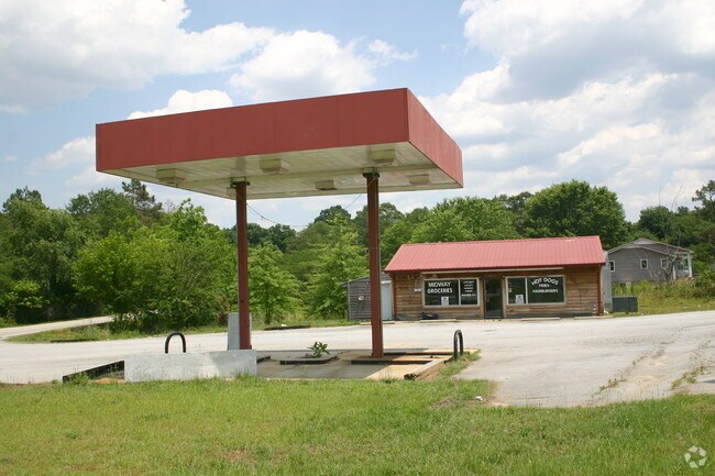
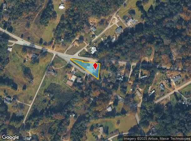
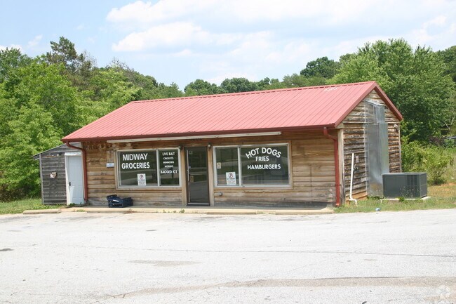
Property Record
3602 Saluda Dam Rd, Easley, SC 29640
NEARBY LISTINGS FOR SALE OR LEASE
Property Detail
3602 Saluda Dam Rd
5150-13-02-7509
LOT PLAT 50/586
Conveniencestore
Pickens
X
South Carolina
45045C0380E
0.50 AC
2025
Pickens County
2024
Greenville/Spartanburg
010603
Greenville-Anderson-Greer, SC
862 SF
DEMOGRAPHICS near 3602 Saluda Dam Rd
1 Mile
3 Mile
5 Mile
2024 Total Population
1,291
19,791
88,835
2029 Population
1,368
21,412
97,071
Pop Growth 2024-2029
+ 5.96%
+ 8.19%
+ 9.27%
Average Age
43
39
39
2024 Total Households
530
7,626
34,851
HH Growth 2024-2029
+ 6.04%
+ 8.23%
+ 9.33%
Median Household Inc
$45,465
$47,224
$44,518
Avg Household Size
2.40
2.50
2.50
2024 Avg HH Vehicles
2.00
2.00
2.00
Median Home Value
$175,520
$158,333
$165,148
Median Year Built
1989
1985
1983
Nearby Places
Map Layers
Map Styles
 Street
 Aerial
- Restaurants
- Banks
- Shops
- Fitness
- Groceries
PUBLIC TRANSPORTATION
COMMUTER RAIL
Greenville Amtrak Station (Crescent - Amtrak)
DRIVE
WALK
Distance
Greenville Amtrak Station (Crescent - Amtrak)
13 min
5.8 mi
AIRPORT
Greenville Spartanburg International
DRIVE
WALK
Distance
Greenville Spartanburg International
36 min
20.7 mi
Freight Ports
North Charleston Terminal
DRIVE
WALK
Distance
North Charleston Terminal
243 min
213.3 mi
SALE & LEASE HISTORY
LISTING DATE
SALE/LEASE

Jan 18, 2017
For Sale
Nearby Properties
Address
Land Use
TOTAL SIZE
Lot Size
Zoning
Address
Land Use
TOTAL SIZE
Lot Size
Zoning
20.04 AC
RM
Address
Land Use
TOTAL SIZE
Lot Size
Zoning
10.10 AC
RM
Address
Land Use
TOTAL SIZE
Lot Size
Zoning
2.14 AC
RM
Address
Land Use
TOTAL SIZE
Lot Size
Zoning
4.97 AC
RM20
Address
Land Use
TOTAL SIZE
Lot Size
Zoning
1.83 AC
RM
Address
Land Use
TOTAL SIZE
Lot Size
Zoning
18.22 AC
RM
Address
Land Use
TOTAL SIZE
Lot Size
Zoning
5.05 AC
C2
Address
Land Use
TOTAL SIZE
Lot Size
Zoning
1.43 AC
C1N
Address
Land Use
TOTAL SIZE
Lot Size
Zoning
153.11 AC
R10
Address
Land Use
TOTAL SIZE
Lot Size
Zoning
1,410 SF
10.17 AC
R10
Address
Land Use
TOTAL SIZE
Lot Size
Zoning
15.82 AC
Address
Land Use
TOTAL SIZE
Lot Size
Zoning
3,008 SF
25.76 AC
C1
Address
Land Use
TOTAL SIZE
Lot Size
Zoning
6.35 AC
RM
Address
Land Use
TOTAL SIZE
Lot Size
Zoning
5,321 SF
3.38 AC
Address
Land Use
TOTAL SIZE
Lot Size
Zoning
24.69 AC
S1
Address
Land Use
TOTAL SIZE
Lot Size
Zoning
43 AC
R12
Address
Land Use
TOTAL SIZE
Lot Size
Zoning
4.03 AC
RS
Address
Land Use
TOTAL SIZE
Lot Size
Zoning
15.71 AC
S1
Address
Land Use
TOTAL SIZE
Lot Size
Zoning
13.09 AC
RM
Address
Land Use
TOTAL SIZE
Lot Size
Zoning
59.60 AC
RS
Address
Land Use
TOTAL SIZE
Lot Size
Zoning
105.62 AC
RS
Address
Land Use
TOTAL SIZE
Lot Size
Zoning
Address
Land Use
TOTAL SIZE
Lot Size
Zoning
28.82 AC
RS,S1
Address
Land Use
TOTAL SIZE
Lot Size
Zoning
13.87 AC
RM20
Address
Land Use
TOTAL SIZE
Lot Size
Zoning
22.50 AC
RM
Address
Land Use
TOTAL SIZE
Lot Size
Zoning
45.40 AC
R12
Address
Land Use
TOTAL SIZE
Lot Size
Zoning
2.67 AC
R12
Address
Land Use
TOTAL SIZE
Lot Size
Zoning
10,000 SF
2.10 AC
Address
Land Use
TOTAL SIZE
Lot Size
Zoning
4.99 AC
C1
The World's #1 Commercial Real Estate Marketplace
Connect with us
© 2026 CoStar Group
The information above has been obtained from sources believed reliable. While we do not doubt its accuracy we have not verified it and make no guarantee, warranty or representation about it. It is your responsibility to independently confirm its accuracy and completeness. Any projections, opinions, assumptions, or estimates used are for example only and do not represent the current or future performance of the property. The value of this transaction to you depends on tax and other factors which should be evaluated by your tax, financial, and legal advisors. You and your advisors should conduct a careful, independent investigation of the property to determine to your satisfaction the suitability of the property for your needs.