No Photo
Property Record
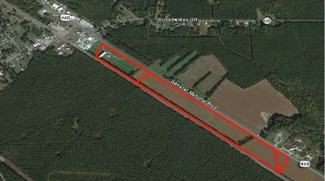
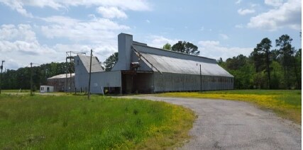
36038 General Mahone Blvd, Ivor, VA 23866

Property Detail
36038 General Mahone Blvd
Medicalbuilding
20 ACRES
M-1
SOUTHAMPTON
B and X Area of moderate flood hazard, usually the area between the limits of the 100-year and 500-year floods.
Virginia
2025
21.68 AC
2025
Virginia Regional
200100
Other Market Areas
4,633 SF
15A2-1-60
NEARBY LISTINGS FOR SALE OR LEASE
-
-
View all Ivor listings for sale on LoopNet.com
DEMOGRAPHICS near 36038 General Mahone Blvd
1 mile
3 mile
5 mile
2025 Total Population
366
1,051
2,132
2030 Population
354
1,018
2,110
Pop Growth 2025-2030
(3.28%)
(3.14%)
(1.03%)
Average Age
45
45
45
2025 Total Households
156
446
882
HH Growth 2025-2030
(3.21%)
(3.14%)
(1.13%)
Median Household Inc
$67,500
$67,115
$70,152
Avg Household Size
2.30
2.40
2.40
2025 Avg HH Vehicles
2.00
2.00
2.00
Median Home Value
$247,777
$249,236
$272,340
Median Year Built
1973
1973
1979
Nearby Places
Map Layers
Map Styles
 Street
 Aerial
Layers
 Traffic
 Biking
Places
Listings with unknown addresses are not visible on the map
- Restaurants
- Banks
- Shops
- Fitness
- Groceries
PUBLIC TRANSPORTATION
AIRPORT
Newport News/Williamsburg International
Drive
Walk
Distance
Newport News/Williamsburg International
69 min
40.4 mi
Freight Ports
Virginia Port Authority - Newport News
Drive
Walk
Distance
Virginia Port Authority - Newport News
57 min
45.6 mi
SALE & LEASE HISTORY
LISTING DATE
SALE/LEASE

Jun 14, 2017
For Sale
Nearby Properties
Address
Land Use
TOTAL SIZE
Lot Size
Zoning
Address
Land Use
TOTAL SIZE
Lot Size
Zoning
4,688 SF
5.55 AC
B-2
Address
Land Use
TOTAL SIZE
Lot Size
Zoning
10,722 SF
1.23 AC
R-1
Address
Land Use
TOTAL SIZE
Lot Size
Zoning
8,916 SF
5.16 AC
B-1
Address
Land Use
TOTAL SIZE
Lot Size
Zoning
4,633 SF
21.68 AC
M-1
Address
Land Use
TOTAL SIZE
Lot Size
Zoning
9,106 SF
1.71 AC
B-2
Address
Land Use
TOTAL SIZE
Lot Size
Zoning
3,703 SF
2.18 AC
A-2
Address
Land Use
TOTAL SIZE
Lot Size
Zoning
1,456 SF
12.18 AC
M-2
Address
Land Use
TOTAL SIZE
Lot Size
Zoning
20,669 SF
0.64 AC
R-1
Address
Land Use
TOTAL SIZE
Lot Size
Zoning
6,443 SF
5.41 AC
R-1
Address
Land Use
TOTAL SIZE
Lot Size
Zoning
5,699 SF
1.03 AC
R-1
Address
Land Use
TOTAL SIZE
Lot Size
Zoning
4,000 SF
2.80 AC
B-2
Address
Land Use
TOTAL SIZE
Lot Size
Zoning
7,000 SF
0.83 AC
B-1
Address
Land Use
TOTAL SIZE
Lot Size
Zoning
1,690 SF
662.70 AC
A-1
Address
Land Use
TOTAL SIZE
Lot Size
Zoning
960 SF
209.19 AC
A-1
Address
Land Use
TOTAL SIZE
Lot Size
Zoning
1.50 AC
A-1
Address
Land Use
TOTAL SIZE
Lot Size
Zoning
0.62 AC
R-1
Address
Land Use
TOTAL SIZE
Lot Size
Zoning
4,800 SF
0.69 AC
B-2
Address
Land Use
TOTAL SIZE
Lot Size
Zoning
1.01 AC
R-1
Address
Land Use
TOTAL SIZE
Lot Size
Zoning
2.32 AC
A-2
Address
Land Use
TOTAL SIZE
Lot Size
Zoning
2,457 SF
1.04 AC
R-1
Address
Land Use
TOTAL SIZE
Lot Size
Zoning
0.46 AC
R-1
Address
Land Use
TOTAL SIZE
Lot Size
Zoning
8,604 SF
1.28 AC
B-2
Address
Land Use
TOTAL SIZE
Lot Size
Zoning
10.39 AC
B-2
Address
Land Use
TOTAL SIZE
Lot Size
Zoning
427 AC
A-1
Address
Land Use
TOTAL SIZE
Lot Size
Zoning
4,490 SF
0.37 AC
R-2
The World's #1 Commercial Real Estate Marketplace
Connect with us
© 2026 CoStar Group
The information above has been obtained from sources believed reliable. While we do not doubt its accuracy we have not verified it and make no guarantee, warranty or representation about it. It is your responsibility to independently confirm its accuracy and completeness. Any projections, opinions, assumptions, or estimates used are for example only and do not represent the current or future performance of the property. The value of this transaction to you depends on tax and other factors which should be evaluated by your tax, financial, and legal advisors. You and your advisors should conduct a careful, independent investigation of the property to determine to your satisfaction the suitability of the property for your needs.