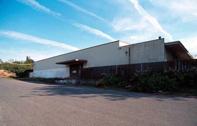
Property Record
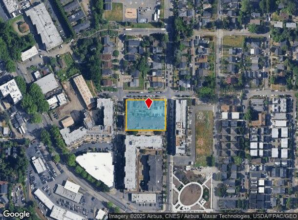
3605 34Th Ave S, Seattle, WA 98144
NEARBY LISTINGS FOR SALE OR LEASE
Property Detail
3605 34Th Ave S
Seattle-Tacoma-Bellevue, WA
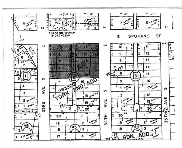
York 2Nd Add
983520-0050
YORK 2ND ADD LOT A SEATTLE LBA #2400103 REC# 20060831900005 SD LBA BEING PORS 5 & 16 & ALL 6 THRU 15 TGW VAC ALLEY PER VAC ORD# 82352 SD BLK 2 LESS POR FOR RDS PER REC# 20140506000013
Warehouse
King
X
Washington
53033C0635G
a
2021
0.81 AC
2024
Rainier/Beacon Hill
009500
Seattle/Puget Sound
58,147 SF
DEMOGRAPHICS near 3605 34Th Ave S
1 Mile
3 Mile
5 Mile
2024 Total Population
21,638
140,514
420,683
2029 Population
22,015
143,404
428,308
Pop Growth 2024-2029
+ 1.74%
+ 2.06%
+ 1.81%
Average Age
40
40
39
2024 Total Households
8,767
59,283
203,478
HH Growth 2024-2029
+ 1.65%
+ 2.25%
+ 1.93%
Median Household Inc
$114,874
$97,034
$112,449
Avg Household Size
2.30
2.20
1.90
2024 Avg HH Vehicles
1.00
1.00
1.00
Median Home Value
$871,487
$846,756
$875,577
Median Year Built
1977
1976
1985
Nearby Places
Map Layers
Map Styles
 Street
 Aerial
- Restaurants
- Banks
- Shops
- Fitness
- Groceries
PUBLIC TRANSPORTATION
TRANSIT/SUBWAY
Mount Baker (Central Link - Central Puget Sound Regional Transit Authority Rail (Link Light Rail/Sounder))
DRIVE
WALK
Distance
Mount Baker (Central Link - Central Puget Sound Regional Transit Authority Rail (Link Light Rail/Sounder))
3 min
14 min
0.7 mi
ST Light Rail & Columbia City Station (NB) (LINK to Sea-Tac - Central Puget Sound Regional Transit Authority Rail (Link Light Rail/Sounder))
DRIVE
WALK
Distance
ST Light Rail & Columbia City Station (NB) (LINK to Sea-Tac - Central Puget Sound Regional Transit Authority Rail (Link Light Rail/Sounder))
4 min
18 min
0.9 mi
Columbia City (Central Link - Central Puget Sound Regional Transit Authority Rail (Link Light Rail/Sounder))
DRIVE
WALK
Distance
Columbia City (Central Link - Central Puget Sound Regional Transit Authority Rail (Link Light Rail/Sounder))
4 min
18 min
0.9 mi
COMMUTER RAIL
King Street (Seattle) Station (Sounder South Line - Central Puget Sound Regional Transit Authority Rail (Link Light Rail/Sounder))
DRIVE
WALK
Distance
King Street (Seattle) Station (Sounder South Line - Central Puget Sound Regional Transit Authority Rail (Link Light Rail/Sounder))
10 min
3.1 mi
AIRPORT
Seattle-Tacoma International
DRIVE
WALK
Distance
Seattle-Tacoma International
26 min
13.6 mi
Seattle Paine Field International
DRIVE
WALK
Distance
Seattle Paine Field International
43 min
27.9 mi
Freight Ports
Port of Seattle
DRIVE
WALK
Distance
Port of Seattle
13 min
4.2 mi
Nearby Properties
Address
Land Use
TOTAL SIZE
Lot Size
Zoning
Address
Land Use
TOTAL SIZE
Lot Size
Zoning
793,990 SF
30.81 AC
UI U/85
Address
Land Use
TOTAL SIZE
Lot Size
Zoning
992,925 SF
4.28 AC
MIO-240-HR
Address
Land Use
TOTAL SIZE
Lot Size
Zoning
1,526,621 SF
1.36 AC
DOC1 U/450
Address
Land Use
TOTAL SIZE
Lot Size
Zoning
7,930 SF
4.14 AC
MIO-240-HR
Address
Land Use
TOTAL SIZE
Lot Size
Zoning
6,379 SF
127.60 AC
MML U/85
Address
Land Use
TOTAL SIZE
Lot Size
Zoning
30,290 SF
564.80 AC
MML U/85
Address
Land Use
TOTAL SIZE
Lot Size
Zoning
1,011,547 SF
0.35 AC
DOC1 U/450
Address
Land Use
TOTAL SIZE
Lot Size
Zoning
540,360 SF
1.31 AC
DMC 340/29
Address
Land Use
TOTAL SIZE
Lot Size
Zoning
726,103 SF
0.17 AC
MIO-240-HR
Address
Land Use
TOTAL SIZE
Lot Size
Zoning
237,533 SF
8.40 AC
LR3 (M)
Address
Land Use
TOTAL SIZE
Lot Size
Zoning
2,800 SF
210.85 AC
NR1
Address
Land Use
TOTAL SIZE
Lot Size
Zoning
385,274 SF
1.31 AC
DOC1 U/450
Address
Land Use
TOTAL SIZE
Lot Size
Zoning
263,600 SF
5.38 AC
II U/160
Address
Land Use
TOTAL SIZE
Lot Size
Zoning
56,474 SF
99.48 AC
MML U/85
Address
Land Use
TOTAL SIZE
Lot Size
Zoning
504,262 SF
0.73 AC
MIO-70-NC3
Address
Land Use
TOTAL SIZE
Lot Size
Zoning
3,045 SF
86.10 AC
MML U/85
Address
Land Use
TOTAL SIZE
Lot Size
Zoning
199,530 SF
1.36 AC
DOC1 U/450
Address
Land Use
TOTAL SIZE
Lot Size
Zoning
680,770 SF
1.50 AC
PSM-85-120
Address
Land Use
TOTAL SIZE
Lot Size
Zoning
344,080 SF
0.17 AC
HR (M)
Address
Land Use
TOTAL SIZE
Lot Size
Zoning
372,242 SF
0.65 AC
DMC 340/29
Address
Land Use
TOTAL SIZE
Lot Size
Zoning
533,910 SF
15.04 AC
MML U/85
Address
Land Use
TOTAL SIZE
Lot Size
Zoning
235,572 SF
0.09 AC
HR (M)
Address
Land Use
TOTAL SIZE
Lot Size
Zoning
162,157 SF
24.06 AC
MML U/85
Address
Land Use
TOTAL SIZE
Lot Size
Zoning
310,490 SF
0.66 AC
DOC1 U/450
Address
Land Use
TOTAL SIZE
Lot Size
Zoning
147,878 SF
13.67 AC
MML U/85
Address
Land Use
TOTAL SIZE
Lot Size
Zoning
241,811 SF
1.89 AC
DMC 340/29
Address
Land Use
TOTAL SIZE
Lot Size
Zoning
218,805 SF
51.21 AC
MIO-105-LR
Address
Land Use
TOTAL SIZE
Lot Size
Zoning
136,140 SF
2.69 AC
MIO-105-MR
The World's #1 Commercial Real Estate Marketplace
Connect with us
© 2026 CoStar Group
The information above has been obtained from sources believed reliable. While we do not doubt its accuracy we have not verified it and make no guarantee, warranty or representation about it. It is your responsibility to independently confirm its accuracy and completeness. Any projections, opinions, assumptions, or estimates used are for example only and do not represent the current or future performance of the property. The value of this transaction to you depends on tax and other factors which should be evaluated by your tax, financial, and legal advisors. You and your advisors should conduct a careful, independent investigation of the property to determine to your satisfaction the suitability of the property for your needs.