Property Record
3605 Kentucky Ave, Indianapolis, IN 46221


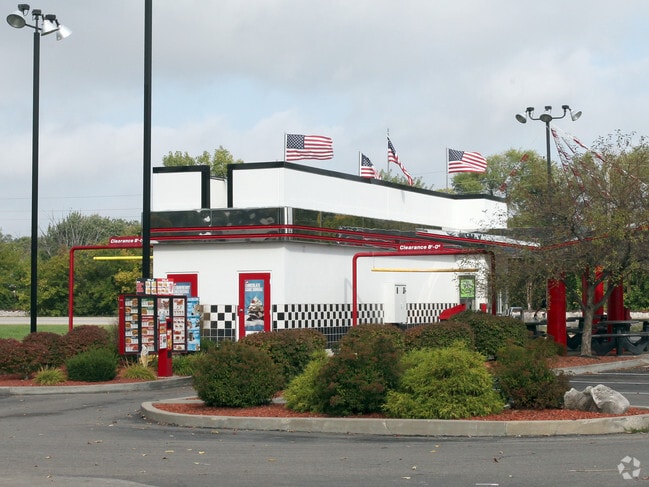
This Property Is For Sale
NEARBY LISTINGS FOR SALE OR LEASE
Property Detail
3605 Kentucky Ave
49-11-30-123-015.000-200
PT NE1/4 S30 T15 R3 1327.09 W SE COR P.O.B. N70.96 NE45.48 NW150 SW112.76 SE116.75 SE66.56 E44.30 TO BEG .46AC
Restaurantdrivein
Marion
X
Indiana
18097C0228F
0.46 AC
2023
Airport
2024
Indianapolis
370201
Indianapolis-Carmel-Anderson, IN
800 SF
DEMOGRAPHICS near 3605 Kentucky Ave
1 Mile
3 Mile
5 Mile
2024 Total Population
10,752
33,583
126,847
2029 Population
10,559
33,096
125,654
Pop Growth 2024-2029
(1.80%)
(1.45%)
(0.94%)
Average Age
36
36
36
2024 Total Households
3,997
12,243
48,019
HH Growth 2024-2029
(1.90%)
(1.54%)
(0.99%)
Median Household Inc
$50,729
$55,587
$54,595
Avg Household Size
2.70
2.70
2.60
2024 Avg HH Vehicles
2.00
2.00
2.00
Median Home Value
$87,174
$114,880
$146,605
Median Year Built
1966
1968
1968
Nearby Places
Map Layers
Map Styles
 Street
 Aerial
- Restaurants
- Banks
- Shops
- Fitness
- Groceries
PUBLIC TRANSPORTATION
COMMUTER RAIL
DRIVE
WALK
Distance
10 min
5.9 mi
AIRPORT
Indianapolis International
DRIVE
WALK
Distance
Indianapolis International
18 min
9.2 mi
Nearby Properties
Address
Land Use
TOTAL SIZE
Lot Size
Zoning
Address
Land Use
TOTAL SIZE
Lot Size
Zoning
434,240 SF
26.25 AC
ZO01
Address
Land Use
TOTAL SIZE
Lot Size
Zoning
9,750 SF
43.46 AC
ZO01
Address
Land Use
TOTAL SIZE
Lot Size
Zoning
366,600 SF
29.05 AC
ZO01
Address
Land Use
TOTAL SIZE
Lot Size
Zoning
49,008 SF
4.80 AC
ZO01
Address
Land Use
TOTAL SIZE
Lot Size
Zoning
133,706 SF
83.24 AC
ZO01
Address
Land Use
TOTAL SIZE
Lot Size
Zoning
12,880 SF
42.54 AC
ZO01
Address
Land Use
TOTAL SIZE
Lot Size
Zoning
101,718 SF
49.77 AC
ZO01
Address
Land Use
TOTAL SIZE
Lot Size
Zoning
595,354 SF
193.41 AC
ZO01
Address
Land Use
TOTAL SIZE
Lot Size
Zoning
20,143 SF
17.10 AC
ZO01
Address
Land Use
TOTAL SIZE
Lot Size
Zoning
537,085 SF
111.99 AC
ZO01
Address
Land Use
TOTAL SIZE
Lot Size
Zoning
161,500 SF
9.95 AC
ZO01
Address
Land Use
TOTAL SIZE
Lot Size
Zoning
1,284 SF
25.09 AC
ZO01
Address
Land Use
TOTAL SIZE
Lot Size
Zoning
178,680 SF
50 AC
ZO01
Address
Land Use
TOTAL SIZE
Lot Size
Zoning
18,209 SF
38.23 AC
ZO01
Address
Land Use
TOTAL SIZE
Lot Size
Zoning
6,794 SF
5.37 AC
ZO01
Address
Land Use
TOTAL SIZE
Lot Size
Zoning
484,008 SF
17.95 AC
ZO01
Address
Land Use
TOTAL SIZE
Lot Size
Zoning
282,183 SF
23.96 AC
ZO01
Address
Land Use
TOTAL SIZE
Lot Size
Zoning
141,697 SF
11.49 AC
ZO01
Address
Land Use
TOTAL SIZE
Lot Size
Zoning
300,160 SF
17.16 AC
ZO01
Address
Land Use
TOTAL SIZE
Lot Size
Zoning
86,701 SF
8.86 AC
ZO01
Address
Land Use
TOTAL SIZE
Lot Size
Zoning
26,755 SF
2.33 AC
Address
Land Use
TOTAL SIZE
Lot Size
Zoning
221,088 SF
16.69 AC
ZO01
Address
Land Use
TOTAL SIZE
Lot Size
Zoning
120,048 SF
12.82 AC
ZO01
Address
Land Use
TOTAL SIZE
Lot Size
Zoning
12,144 SF
8.65 AC
ZO01
Address
Land Use
TOTAL SIZE
Lot Size
Zoning
30,907 SF
4.35 AC
ZO01
Address
Land Use
TOTAL SIZE
Lot Size
Zoning
26,476 SF
2.51 AC
ZO01
Address
Land Use
TOTAL SIZE
Lot Size
Zoning
81,900 SF
6.98 AC
ZO01
Address
Land Use
TOTAL SIZE
Lot Size
Zoning
65,899 SF
17.39 AC
ZO01
Address
Land Use
TOTAL SIZE
Lot Size
Zoning
355,250 SF
42.64 AC
ZO01
Address
Land Use
TOTAL SIZE
Lot Size
Zoning
253,928 SF
13.49 AC
ZO01
The World's #1 Commercial Real Estate Marketplace
Connect with us
© 2026 CoStar Group
The information above has been obtained from sources believed reliable. While we do not doubt its accuracy we have not verified it and make no guarantee, warranty or representation about it. It is your responsibility to independently confirm its accuracy and completeness. Any projections, opinions, assumptions, or estimates used are for example only and do not represent the current or future performance of the property. The value of this transaction to you depends on tax and other factors which should be evaluated by your tax, financial, and legal advisors. You and your advisors should conduct a careful, independent investigation of the property to determine to your satisfaction the suitability of the property for your needs.