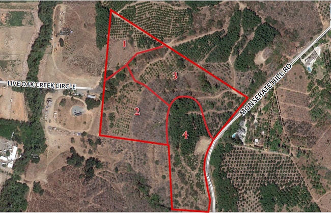
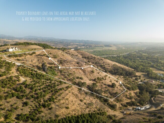
Property Record
3606 Monserate Hill Rd, Bonsall, CA 92003

NEARBY LISTINGS FOR SALE OR LEASE
Property Detail
3606 Monserate Hill Rd
124-351-07
PAR 3 TR PM10168
Orchard
San Diego
X
California
06073C0480G
6.76 AC
2024
Outlying SD County N
2025
San Diego
018803
San Diego-Carlsbad, CA
DEMOGRAPHICS near 3606 Monserate Hill Rd
1 Mile
3 Mile
5 Mile
2024 Total Population
761
14,453
37,986
2029 Population
753
14,373
37,805
Pop Growth 2024-2029
(1.05%)
(0.55%)
(0.48%)
Average Age
52
46
44
2024 Total Households
295
5,295
13,268
HH Growth 2024-2029
(1.36%)
(0.68%)
(0.66%)
Median Household Inc
$144,530
$117,791
$111,450
Avg Household Size
2.60
2.70
2.80
2024 Avg HH Vehicles
3.00
2.00
3.00
Median Home Value
$834,269
$813,676
$799,808
Median Year Built
1992
1990
1988
Nearby Places
Map Layers
Map Styles
 Street
 Aerial
- Restaurants
- Banks
- Shops
- Fitness
- Groceries
SALE & LEASE HISTORY
LISTING DATE
SALE/LEASE

Jul 26, 2017
For Sale
Aug 17, 2022
For Sale
Nearby Properties
Address
Land Use
TOTAL SIZE
Lot Size
Zoning
Address
Land Use
TOTAL SIZE
Lot Size
Zoning
13,878 SF
880.39 AC
A70
Address
Land Use
TOTAL SIZE
Lot Size
Zoning
29,600 SF
1.51 AC
RU
Address
Land Use
TOTAL SIZE
Lot Size
Zoning
97.01 AC
A70
Address
Land Use
TOTAL SIZE
Lot Size
Zoning
11,840 SF
6.59 AC
A70
Address
Land Use
TOTAL SIZE
Lot Size
Zoning
3,156 SF
203.62 AC
A70
Address
Land Use
TOTAL SIZE
Lot Size
Zoning
24,183 SF
100.90 AC
RRO
Address
Land Use
TOTAL SIZE
Lot Size
Zoning
84,375 SF
12.04 AC
C36
Address
Land Use
TOTAL SIZE
Lot Size
Zoning
19,391 SF
1.71 AC
C36
Address
Land Use
TOTAL SIZE
Lot Size
Zoning
4.18 AC
A70
Address
Land Use
TOTAL SIZE
Lot Size
Zoning
37.10 AC
A70
Address
Land Use
TOTAL SIZE
Lot Size
Zoning
78,410 SF
7.41 AC
C36
Address
Land Use
TOTAL SIZE
Lot Size
Zoning
2,589 SF
8.92 AC
A70
Address
Land Use
TOTAL SIZE
Lot Size
Zoning
6,951 SF
34.15 AC
RR
Address
Land Use
TOTAL SIZE
Lot Size
Zoning
10,508 SF
26.11 AC
RR
Address
Land Use
TOTAL SIZE
Lot Size
Zoning
7,174 SF
3.88 AC
C36
Address
Land Use
TOTAL SIZE
Lot Size
Zoning
38.93 AC
A72
Address
Land Use
TOTAL SIZE
Lot Size
Zoning
3.94 AC
C30
Address
Land Use
TOTAL SIZE
Lot Size
Zoning
5.04 AC
A70
Address
Land Use
TOTAL SIZE
Lot Size
Zoning
5 AC
A70
Address
Land Use
TOTAL SIZE
Lot Size
Zoning
177.93 AC
A70
Address
Land Use
TOTAL SIZE
Lot Size
Zoning
35.77 AC
A72
Address
Land Use
TOTAL SIZE
Lot Size
Zoning
28,782 SF
1.50 AC
RU
Address
Land Use
TOTAL SIZE
Lot Size
Zoning
27,880 SF
1.63 AC
RU
Address
Land Use
TOTAL SIZE
Lot Size
Zoning
6,487 SF
15.42 AC
A70
Address
Land Use
TOTAL SIZE
Lot Size
Zoning
6.26 AC
A70
Address
Land Use
TOTAL SIZE
Lot Size
Zoning
53.92 AC
S80
Address
Land Use
TOTAL SIZE
Lot Size
Zoning
7,329 SF
9.56 AC
A70
Address
Land Use
TOTAL SIZE
Lot Size
Zoning
16.49 AC
A70
Address
Land Use
TOTAL SIZE
Lot Size
Zoning
7,120 SF
2.04 AC
A70
Address
Land Use
TOTAL SIZE
Lot Size
Zoning
23.55 AC
A70
The World's #1 Commercial Real Estate Marketplace
Connect with us
© 2025 CoStar Group
The information above has been obtained from sources believed reliable. While we do not doubt its accuracy we have not verified it and make no guarantee, warranty or representation about it. It is your responsibility to independently confirm its accuracy and completeness. Any projections, opinions, assumptions, or estimates used are for example only and do not represent the current or future performance of the property. The value of this transaction to you depends on tax and other factors which should be evaluated by your tax, financial, and legal advisors. You and your advisors should conduct a careful, independent investigation of the property to determine to your satisfaction the suitability of the property for your needs.