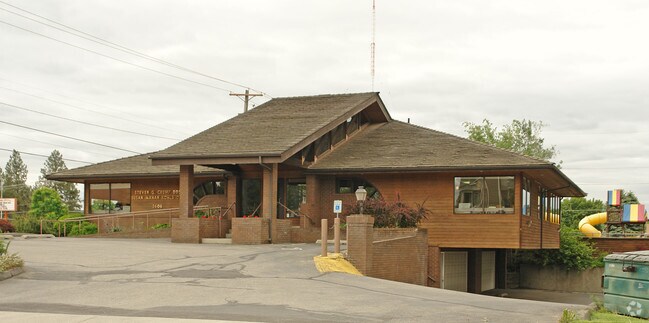
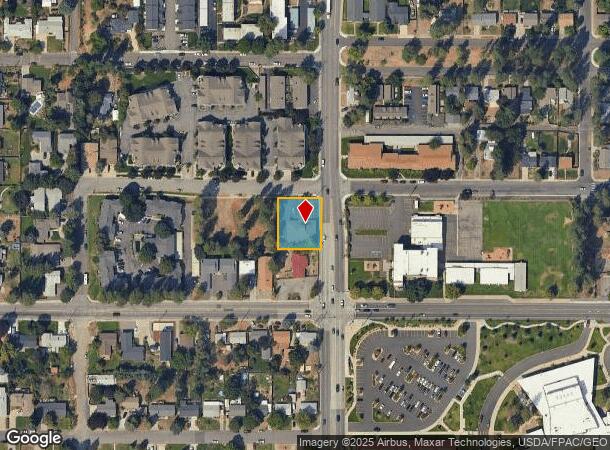
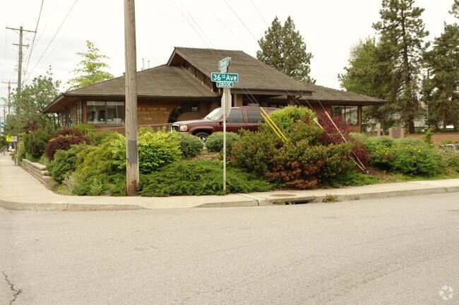
Property Record
3606 S Regal St, Spokane, WA 99223
NEARBY LISTINGS FOR SALE OR LEASE
Property Detail
3606 S Regal St
Spokane-Spokane Valley, WA
Garden Park
35331.2309
GARDEN PARK FENNERS RES LTS 1 & 2 BLK 1 & N1/2 OF VAC AL LEY LYG S & ADJ
Commercialnec
Spokane
X
Washington
53063C0726D
1,2
2025
0.36 AC
2025
South Hill
004702
Spokane
3,500 SF
DEMOGRAPHICS near 3606 S Regal St
1 Mile
3 Mile
5 Mile
2024 Total Population
17,403
78,016
164,078
2029 Population
18,609
83,187
174,949
Pop Growth 2024-2029
+ 6.93%
+ 6.63%
+ 6.63%
Average Age
42
41
40
2024 Total Households
7,583
32,398
69,094
HH Growth 2024-2029
+ 7.21%
+ 6.84%
+ 6.96%
Median Household Inc
$63,220
$77,471
$61,719
Avg Household Size
2.20
2.30
2.20
2024 Avg HH Vehicles
2.00
2.00
2.00
Median Home Value
$379,417
$410,734
$360,869
Median Year Built
1985
1976
1971
Nearby Places
Map Layers
Map Styles
 Street
 Aerial
- Restaurants
- Banks
- Shops
- Fitness
- Groceries
PUBLIC TRANSPORTATION
COMMUTER RAIL
DRIVE
WALK
Distance
11 min
4.1 mi
AIRPORT
Spokane International
DRIVE
WALK
Distance
Spokane International
20 min
10.2 mi
Nearby Properties
Address
Land Use
TOTAL SIZE
Lot Size
Zoning
Address
Land Use
TOTAL SIZE
Lot Size
Zoning
763,627 SF
12.44 AC
OR
Address
Land Use
TOTAL SIZE
Lot Size
Zoning
226,702 SF
49.25 AC
RSF
Address
Land Use
TOTAL SIZE
Lot Size
Zoning
365,804 SF
16.13 AC
RSF
Address
Land Use
TOTAL SIZE
Lot Size
Zoning
251,542 SF
5.78 AC
DTG
Address
Land Use
TOTAL SIZE
Lot Size
Zoning
270,262 SF
29.10 AC
Address
Land Use
TOTAL SIZE
Lot Size
Zoning
218,684 SF
13.29 AC
RMF
Address
Land Use
TOTAL SIZE
Lot Size
Zoning
124,234 SF
13.54 AC
RSF
Address
Land Use
TOTAL SIZE
Lot Size
Zoning
210,277 SF
19.18 AC
RMF
Address
Land Use
TOTAL SIZE
Lot Size
Zoning
289,573 SF
7.73 AC
RMF
Address
Land Use
TOTAL SIZE
Lot Size
Zoning
135,715 SF
4.73 AC
RMF
Address
Land Use
TOTAL SIZE
Lot Size
Zoning
119,933 SF
5.61 AC
Address
Land Use
TOTAL SIZE
Lot Size
Zoning
138,840 SF
2.79 AC
DTU
Address
Land Use
TOTAL SIZE
Lot Size
Zoning
159,720 SF
6.84 AC
RMF
Address
Land Use
TOTAL SIZE
Lot Size
Zoning
66,193 SF
1.99 AC
OR
Address
Land Use
TOTAL SIZE
Lot Size
Zoning
78,990 SF
5.58 AC
RSF
Address
Land Use
TOTAL SIZE
Lot Size
Zoning
79,200 SF
OR
Address
Land Use
TOTAL SIZE
Lot Size
Zoning
173,714 SF
9.98 AC
HDR
Address
Land Use
TOTAL SIZE
Lot Size
Zoning
119,910 SF
3.66 AC
OR
Address
Land Use
TOTAL SIZE
Lot Size
Zoning
142,500 SF
6.86 AC
RMF
Address
Land Use
TOTAL SIZE
Lot Size
Zoning
81,833 SF
3.97 AC
OR
Address
Land Use
TOTAL SIZE
Lot Size
Zoning
172,388 SF
13.59 AC
RSF
Address
Land Use
TOTAL SIZE
Lot Size
Zoning
59,826 SF
6.79 AC
RSF
Address
Land Use
TOTAL SIZE
Lot Size
Zoning
55,623 SF
4.46 AC
MU
Address
Land Use
TOTAL SIZE
Lot Size
Zoning
75,680 SF
3.93 AC
RSF
Address
Land Use
TOTAL SIZE
Lot Size
Zoning
107,442 SF
5.57 AC
MF-2
Address
Land Use
TOTAL SIZE
Lot Size
Zoning
339,500 SF
2.80 AC
Address
Land Use
TOTAL SIZE
Lot Size
Zoning
144,382 SF
5.43 AC
CC2
Address
Land Use
TOTAL SIZE
Lot Size
Zoning
130,878 SF
5.57 AC
CC2
Address
Land Use
TOTAL SIZE
Lot Size
Zoning
150,812 SF
17.49 AC
RC
Address
Land Use
TOTAL SIZE
Lot Size
Zoning
105,728 SF
4.53 AC
RMF
The World's #1 Commercial Real Estate Marketplace
Connect with us
© 2025 CoStar Group
The information above has been obtained from sources believed reliable. While we do not doubt its accuracy we have not verified it and make no guarantee, warranty or representation about it. It is your responsibility to independently confirm its accuracy and completeness. Any projections, opinions, assumptions, or estimates used are for example only and do not represent the current or future performance of the property. The value of this transaction to you depends on tax and other factors which should be evaluated by your tax, financial, and legal advisors. You and your advisors should conduct a careful, independent investigation of the property to determine to your satisfaction the suitability of the property for your needs.