Property Record
3606 Thomas Rd, Oxford, MI 48371
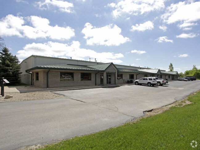


Property Detail
3606 Thomas Rd
04-04-162-001
T5N, R10E, SEC 4 PART OF NW FRC 1/4 BEG AT PT DIST N 165 FT FROM W 1/4 COR TH N TO S LINE OF 'VILLAGE OF THOMAS', TH E 1102.7 FT, TH S PARA TO W SEC LINE TO A PT 165 FT N OF E & W 1/4 LINE, TH W TO BEG, EXC THAT PART TAKEN FOR M-24 HWY 9.11 A P58
Loftbuilding
Oakland
II
Michigan
B and X Area of moderate flood hazard, usually the area between the limits of the 100-year and 500-year floods.
9.11 AC
2024
Auburn Hills, Pontiac & Rochester
2025
Detroit
121000
Detroit-Warren-Dearborn, MI
27,912 SF
NEARBY LISTINGS FOR SALE OR LEASE
DEMOGRAPHICS near 3606 Thomas Rd
1 mile
3 mile
5 mile
2025 Total Population
987
5,541
23,386
2030 Population
1,006
5,680
23,819
Pop Growth 2025-2030
+ 1.93%
+ 2.51%
+ 1.85%
Average Age
45
43
42
2025 Total Households
365
2,018
8,651
HH Growth 2025-2030
+ 1.92%
+ 2.53%
+ 1.88%
Median Household Inc
$132,181
$113,228
$112,465
Avg Household Size
2.70
2.70
2.70
2025 Avg HH Vehicles
3.00
2.00
2.00
Median Home Value
$377,396
$393,423
$375,494
Median Year Built
1984
1993
1989
Nearby Places
Map Layers
Map Styles
 Street
 Aerial
Layers
 Traffic
 Biking
Places
Listings with unknown addresses are not visible on the map
- Restaurants
- Banks
- Shops
- Fitness
- Groceries
PUBLIC TRANSPORTATION
AIRPORT
Bishop International
Drive
Walk
Distance
Bishop International
55 min
38.2 mi
Freight Ports
Port of Toledo
Drive
Walk
Distance
Port of Toledo
132 min
105.3 mi
Nearby Properties
Address
Land Use
TOTAL SIZE
Lot Size
Zoning
Address
Land Use
TOTAL SIZE
Lot Size
Zoning
148,898 SF
14.55 AC
BI
Address
Land Use
TOTAL SIZE
Lot Size
Zoning
188,367 SF
Address
Land Use
TOTAL SIZE
Lot Size
Zoning
188,367 SF
26.37 AC
Address
Land Use
TOTAL SIZE
Lot Size
Zoning
207,073 SF
19.74 AC
Address
Land Use
TOTAL SIZE
Lot Size
Zoning
78,297 SF
7.53 AC
II
Address
Land Use
TOTAL SIZE
Lot Size
Zoning
70,420 SF
4.49 AC
II
Address
Land Use
TOTAL SIZE
Lot Size
Zoning
61,936 SF
4.71 AC
II
Address
Land Use
TOTAL SIZE
Lot Size
Zoning
51,898 SF
3.56 AC
II
Address
Land Use
TOTAL SIZE
Lot Size
Zoning
60,600 SF
14.31 AC
II
Address
Land Use
TOTAL SIZE
Lot Size
Zoning
49,731 SF
5.75 AC
II
Address
Land Use
TOTAL SIZE
Lot Size
Zoning
52,000 SF
5.13 AC
II
Address
Land Use
TOTAL SIZE
Lot Size
Zoning
68,162 SF
4.97 AC
II
Address
Land Use
TOTAL SIZE
Lot Size
Zoning
52,336 SF
5.72 AC
II
Address
Land Use
TOTAL SIZE
Lot Size
Zoning
57,809 SF
6.61 AC
BI
Address
Land Use
TOTAL SIZE
Lot Size
Zoning
17,936 SF
7.69 AC
IV
Address
Land Use
TOTAL SIZE
Lot Size
Zoning
45,554 SF
2.74 AC
II
Address
Land Use
TOTAL SIZE
Lot Size
Zoning
46,838 SF
4.56 AC
II
Address
Land Use
TOTAL SIZE
Lot Size
Zoning
22,767 SF
4.60 AC
II
Address
Land Use
TOTAL SIZE
Lot Size
Zoning
44,019 SF
2.29 AC
Address
Land Use
TOTAL SIZE
Lot Size
Zoning
2,827 SF
89 AC
MM
Address
Land Use
TOTAL SIZE
Lot Size
Zoning
14,571 SF
1.92 AC
BI
Address
Land Use
TOTAL SIZE
Lot Size
Zoning
23,820 SF
9.74 AC
II
Address
Land Use
TOTAL SIZE
Lot Size
Zoning
14,792 SF
6.28 AC
II
Address
Land Use
TOTAL SIZE
Lot Size
Zoning
25,822 SF
4.55 AC
II
Address
Land Use
TOTAL SIZE
Lot Size
Zoning
7 AC
MM
The World's #1 Commercial Real Estate Marketplace
Connect with us
© 2026 CoStar Group
The information above has been obtained from sources believed reliable. While we do not doubt its accuracy we have not verified it and make no guarantee, warranty or representation about it. It is your responsibility to independently confirm its accuracy and completeness. Any projections, opinions, assumptions, or estimates used are for example only and do not represent the current or future performance of the property. The value of this transaction to you depends on tax and other factors which should be evaluated by your tax, financial, and legal advisors. You and your advisors should conduct a careful, independent investigation of the property to determine to your satisfaction the suitability of the property for your needs.