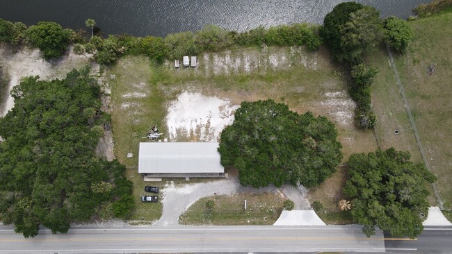
Property Record
3606 Us Highway 441 Se, Okeechobee, FL 34974


Current Lease Availabilities
NEARBY LISTINGS FOR SALE OR LEASE
-
-
View all Okeechobee listings for lease on LoopNet.com
Property Detail
3606 Us Highway 441 Se
Okeechobee, FL
Okeechobee
R1-36-37-35-0A00-00005-0000
ALL THAT PART OF THE WEST 331.25 FEET OF GOVERNMENT LOT 1, SECTION 36, TOWNSHIP 37 SOUTH, RANGE 35 EAST, LYING BETWEEN THE SOUTH RIGHT-OF-WAY LINE OF STATE ROAD #15 AND THE NORTH SHORE LEVEE RIGHT-OF-WAY LESS THAT CERTAIN PARCEL DEEDED TO THE CENTRAL
Warehouse
Okeechobee
AE
Florida
12043C0100D
1
2025
1.44 AC
2025
Florida Central South Area
910403
Other Market Areas
3,500 SF
DEMOGRAPHICS near 3606 Us Highway 441 Se
1 mile
3 mile
5 mile
2024 Total Population
3,640
13,131
24,317
2029 Population
3,889
14,138
25,995
Pop Growth 2024-2029
+ 6.84%
+ 7.67%
+ 6.90%
Average Age
47
46
44
2024 Total Households
1,694
5,785
9,915
HH Growth 2024-2029
+ 6.91%
+ 7.90%
+ 7.24%
Median Household Inc
$40,129
$40,751
$42,816
Avg Household Size
2.10
2.20
2.40
2024 Avg HH Vehicles
2.00
2.00
2.00
Median Home Value
$118,497
$119,659
$127,244
Median Year Built
1984
1987
1986
Nearby Places
Map Layers
Map Styles
 Street
 Aerial
Transit
 Traffic
 Biking
Places
Listings with unknown addresses are not visible on the map
- Restaurants
- Banks
- Shops
- Fitness
- Groceries
PUBLIC TRANSPORTATION
COMMUTER RAIL
Drive
Walk
Distance
12 min
5.5 mi
Freight Ports
Port of Palm Beach
Drive
Walk
Distance
Port of Palm Beach
81 min
56.5 mi
Nearby Properties
Address
Land Use
TOTAL SIZE
Lot Size
Zoning
Address
Land Use
TOTAL SIZE
Lot Size
Zoning
46,720 SF
108.57 AC
Address
Land Use
TOTAL SIZE
Lot Size
Zoning
194,141 SF
30.69 AC
Address
Land Use
TOTAL SIZE
Lot Size
Zoning
122,024 SF
14.12 AC
Address
Land Use
TOTAL SIZE
Lot Size
Zoning
133,382 SF
1.52 AC
Address
Land Use
TOTAL SIZE
Lot Size
Zoning
90,801 SF
15.10 AC
Address
Land Use
TOTAL SIZE
Lot Size
Zoning
158,401 SF
14.89 AC
Address
Land Use
TOTAL SIZE
Lot Size
Zoning
50,633 SF
4.22 AC
Address
Land Use
TOTAL SIZE
Lot Size
Zoning
9,231 SF
10.56 AC
Address
Land Use
TOTAL SIZE
Lot Size
Zoning
23,460 SF
8 AC
Address
Land Use
TOTAL SIZE
Lot Size
Zoning
121,250 SF
10.31 AC
Address
Land Use
TOTAL SIZE
Lot Size
Zoning
75,023 SF
14.50 AC
Address
Land Use
TOTAL SIZE
Lot Size
Zoning
2,887 SF
11.76 AC
Address
Land Use
TOTAL SIZE
Lot Size
Zoning
42,074 SF
34.62 AC
Address
Land Use
TOTAL SIZE
Lot Size
Zoning
118,008 SF
145.36 AC
Address
Land Use
TOTAL SIZE
Lot Size
Zoning
76,008 SF
8.55 AC
Address
Land Use
TOTAL SIZE
Lot Size
Zoning
66,230 SF
5.12 AC
Address
Land Use
TOTAL SIZE
Lot Size
Zoning
62,297 SF
11.48 AC
Address
Land Use
TOTAL SIZE
Lot Size
Zoning
36,381 SF
2.48 AC
Address
Land Use
TOTAL SIZE
Lot Size
Zoning
3,176 SF
38.74 AC
Address
Land Use
TOTAL SIZE
Lot Size
Zoning
80,857 SF
5.48 AC
Address
Land Use
TOTAL SIZE
Lot Size
Zoning
51,475 SF
8.66 AC
Address
Land Use
TOTAL SIZE
Lot Size
Zoning
4,293 SF
14.62 AC
Address
Land Use
TOTAL SIZE
Lot Size
Zoning
45,770 SF
7.70 AC
Address
Land Use
TOTAL SIZE
Lot Size
Zoning
54,287 SF
2.67 AC
Address
Land Use
TOTAL SIZE
Lot Size
Zoning
8,954 SF
3.41 AC
Address
Land Use
TOTAL SIZE
Lot Size
Zoning
42,323 SF
6.84 AC
Address
Land Use
TOTAL SIZE
Lot Size
Zoning
43,759 SF
9.70 AC
Address
Land Use
TOTAL SIZE
Lot Size
Zoning
448.30 AC
Address
Land Use
TOTAL SIZE
Lot Size
Zoning
6,814 SF
2.55 AC
Address
Land Use
TOTAL SIZE
Lot Size
Zoning
160 SF
10.85 AC
The World's #1 Commercial Real Estate Marketplace
Connect with us
© 2026 CoStar Group
The information above has been obtained from sources believed reliable. While we do not doubt its accuracy we have not verified it and make no guarantee, warranty or representation about it. It is your responsibility to independently confirm its accuracy and completeness. Any projections, opinions, assumptions, or estimates used are for example only and do not represent the current or future performance of the property. The value of this transaction to you depends on tax and other factors which should be evaluated by your tax, financial, and legal advisors. You and your advisors should conduct a careful, independent investigation of the property to determine to your satisfaction the suitability of the property for your needs.