Property Record
3609 Us Route 9, Hudson, NY 12534
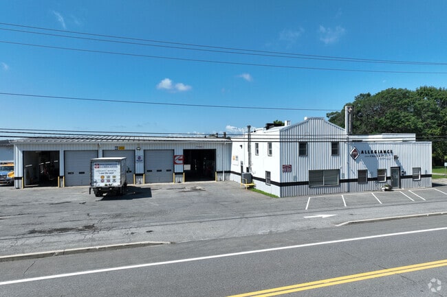

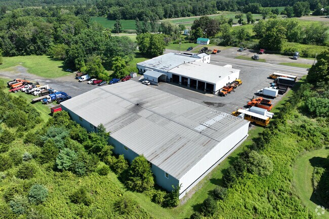
Property Detail
3609 Us Route 9
104000-140-000-0001-026-000-0000
Columbia
Vehiclerentalsvehiclesales
New York
401
26.000
2025
6.10 AC
2025
Columbia County
001100
Albany/Schenectady/Troy
8,400 SF
Hudson, NY
NEARBY LISTINGS FOR SALE OR LEASE
-
-
View all Hudson listings for sale on LoopNet.com
DEMOGRAPHICS near 3609 Us Route 9
1 mile
3 mile
5 mile
2025 Total Population
498
2,329
13,445
2030 Population
487
2,276
13,137
Pop Growth 2025-2030
(2.21%)
(2.28%)
(2.29%)
Average Age
47
47
45
2025 Total Households
218
1,021
6,032
HH Growth 2025-2030
(2.29%)
(2.45%)
(2.39%)
Median Household Inc
$69,843
$80,082
$69,539
Avg Household Size
2.20
2.20
2.10
2025 Avg HH Vehicles
2.00
2.00
2.00
Median Home Value
$330,769
$319,565
$324,056
Median Year Built
1974
1973
1956
Nearby Places
Map Layers
Map Styles
 Street
 Aerial
Layers
 Traffic
 Biking
Places
Listings with unknown addresses are not visible on the map
- Restaurants
- Banks
- Shops
- Fitness
- Groceries
PUBLIC TRANSPORTATION
COMMUTER RAIL
Drive
Walk
Distance
11 min
5.9 mi
Freight Ports
Albany, NY Port
Drive
Walk
Distance
Albany, NY Port
49 min
36.8 mi
Nearby Properties
Address
Land Use
TOTAL SIZE
Lot Size
Zoning
Address
Land Use
TOTAL SIZE
Lot Size
Zoning
1,226.97 AC
07
Address
Land Use
TOTAL SIZE
Lot Size
Zoning
150,204 SF
31.51 AC
07 - MIXED
Address
Land Use
TOTAL SIZE
Lot Size
Zoning
216 SF
220.20 AC
07 - MIXED
Address
Land Use
TOTAL SIZE
Lot Size
Zoning
12,273 SF
159.66 AC
07 - MIXED
Address
Land Use
TOTAL SIZE
Lot Size
Zoning
3,996 SF
66 AC
07 - MIXED
Address
Land Use
TOTAL SIZE
Lot Size
Zoning
5,230 SF
29.70 AC
01 - NOT Z
Address
Land Use
TOTAL SIZE
Lot Size
Zoning
41,125 SF
89.60 AC
07 - MIXED
Address
Land Use
TOTAL SIZE
Lot Size
Zoning
25 AC
03 - MULTI
Address
Land Use
TOTAL SIZE
Lot Size
Zoning
42,571 SF
80.67 AC
07 - MIXED
Address
Land Use
TOTAL SIZE
Lot Size
Zoning
33.84 AC
08 - GOVER
Address
Land Use
TOTAL SIZE
Lot Size
Zoning
1,932 SF
435 AC
07 - MIXED
Address
Land Use
TOTAL SIZE
Lot Size
Zoning
21.29 AC
01 - NOT Z
Address
Land Use
TOTAL SIZE
Lot Size
Zoning
24,000 SF
4.34 AC
07 - MIXED
Address
Land Use
TOTAL SIZE
Lot Size
Zoning
3,456 SF
5.60 AC
401
Address
Land Use
TOTAL SIZE
Lot Size
Zoning
792 SF
8 AC
01 - NOT Z
Address
Land Use
TOTAL SIZE
Lot Size
Zoning
2,016 SF
69.02 AC
01 - NOT Z
Address
Land Use
TOTAL SIZE
Lot Size
Zoning
3,000 SF
7.70 AC
401
Address
Land Use
TOTAL SIZE
Lot Size
Zoning
4,208 SF
101.76 AC
07 - MIXED
Address
Land Use
TOTAL SIZE
Lot Size
Zoning
4,862 SF
3.22 AC
04 - FARM
Address
Land Use
TOTAL SIZE
Lot Size
Zoning
2,184 SF
3.60 AC
401
Address
Land Use
TOTAL SIZE
Lot Size
Zoning
2,760 SF
40.59 AC
07 - MIXED
Address
Land Use
TOTAL SIZE
Lot Size
Zoning
10,604 SF
130.75 AC
07 - MIXED
Address
Land Use
TOTAL SIZE
Lot Size
Zoning
17,814 SF
5.11 AC
401
Address
Land Use
TOTAL SIZE
Lot Size
Zoning
2,860 SF
10 AC
07 - MIXED
Address
Land Use
TOTAL SIZE
Lot Size
Zoning
130 AC
03 - MULTI
Address
Land Use
TOTAL SIZE
Lot Size
Zoning
14,000 SF
50 AC
07 - MIXED
Address
Land Use
TOTAL SIZE
Lot Size
Zoning
7,370 SF
6.10 AC
07 - MIXED
Address
Land Use
TOTAL SIZE
Lot Size
Zoning
46,860 SF
14.07 AC
07 - MIXED
Address
Land Use
TOTAL SIZE
Lot Size
Zoning
173 AC
03
The World's #1 Commercial Real Estate Marketplace
Connect with us
© 2026 CoStar Group
The information above has been obtained from sources believed reliable. While we do not doubt its accuracy we have not verified it and make no guarantee, warranty or representation about it. It is your responsibility to independently confirm its accuracy and completeness. Any projections, opinions, assumptions, or estimates used are for example only and do not represent the current or future performance of the property. The value of this transaction to you depends on tax and other factors which should be evaluated by your tax, financial, and legal advisors. You and your advisors should conduct a careful, independent investigation of the property to determine to your satisfaction the suitability of the property for your needs.