Property Record
361 22Nd St E, Dickinson, ND 58601
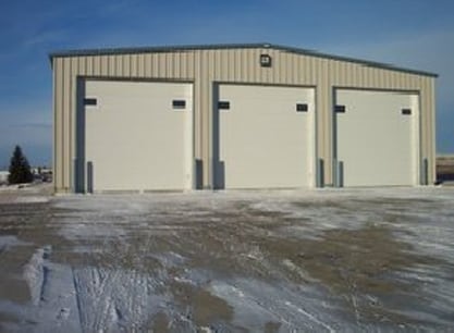

Property Detail
361 22Nd St E
Dickinson, ND
LOTS 1 & 2, BLOCK 1, KILWEIN 2ND ADDITION
41096001000100
Stark
Commercialnec
North Dakota
B and X Area of moderate flood hazard, usually the area between the limits of the 100-year and 500-year floods.
1-2
2025
0.92 AC
2025
North Dakota Area
963400
Other Market Areas
8,000 SF
NEARBY LISTINGS FOR SALE OR LEASE
DEMOGRAPHICS near 361 22Nd St E
1 mile
3 mile
5 mile
2025 Total Population
4,412
24,434
28,580
2030 Population
4,576
25,059
29,443
Pop Growth 2025-2030
+ 3.72%
+ 2.56%
+ 3.02%
Average Age
37
37
36
2025 Total Households
1,797
10,024
11,639
HH Growth 2025-2030
+ 3.78%
+ 2.64%
+ 3.08%
Median Household Inc
$83,463
$82,669
$82,621
Avg Household Size
2.40
2.30
2.40
2025 Avg HH Vehicles
2.00
2.00
2.00
Median Home Value
$271,896
$279,530
$278,769
Median Year Built
1995
1987
1988
Nearby Places
Map Layers
Map Styles
 Street
 Aerial
Layers
 Traffic
 Biking
Places
Listings with unknown addresses are not visible on the map
- Restaurants
- Banks
- Shops
- Fitness
- Groceries
Nearby Properties
Address
Land Use
TOTAL SIZE
Lot Size
Zoning
Address
Land Use
TOTAL SIZE
Lot Size
Zoning
82,317 SF
9.28 AC
Address
Land Use
TOTAL SIZE
Lot Size
Zoning
360 SF
14.52 AC
Address
Land Use
TOTAL SIZE
Lot Size
Zoning
200,215 SF
24.52 AC
Address
Land Use
TOTAL SIZE
Lot Size
Zoning
40,468 SF
11.66 AC
Address
Land Use
TOTAL SIZE
Lot Size
Zoning
33,400 SF
40.02 AC
Address
Land Use
TOTAL SIZE
Lot Size
Zoning
140,864 SF
22.24 AC
Address
Land Use
TOTAL SIZE
Lot Size
Zoning
43,896 SF
8.47 AC
Address
Land Use
TOTAL SIZE
Lot Size
Zoning
53,064 SF
9.79 AC
Address
Land Use
TOTAL SIZE
Lot Size
Zoning
53,064 SF
7.70 AC
Address
Land Use
TOTAL SIZE
Lot Size
Zoning
84,176 SF
11.87 AC
Address
Land Use
TOTAL SIZE
Lot Size
Zoning
48,580 SF
7.04 AC
Address
Land Use
TOTAL SIZE
Lot Size
Zoning
47,520 SF
6.79 AC
Address
Land Use
TOTAL SIZE
Lot Size
Zoning
40,608 SF
18.38 AC
Address
Land Use
TOTAL SIZE
Lot Size
Zoning
29.52 AC
Address
Land Use
TOTAL SIZE
Lot Size
Zoning
10,759 SF
17.99 AC
Address
Land Use
TOTAL SIZE
Lot Size
Zoning
50,620 SF
13.60 AC
Address
Land Use
TOTAL SIZE
Lot Size
Zoning
50,909 SF
6.19 AC
Address
Land Use
TOTAL SIZE
Lot Size
Zoning
63,000 SF
34.67 AC
Address
Land Use
TOTAL SIZE
Lot Size
Zoning
85,428 SF
4 AC
Address
Land Use
TOTAL SIZE
Lot Size
Zoning
23,742 SF
4.95 AC
Address
Land Use
TOTAL SIZE
Lot Size
Zoning
90,608 SF
7.56 AC
Address
Land Use
TOTAL SIZE
Lot Size
Zoning
55,500 SF
14.24 AC
Address
Land Use
TOTAL SIZE
Lot Size
Zoning
35,826 SF
4.90 AC
Address
Land Use
TOTAL SIZE
Lot Size
Zoning
21,770 SF
8.40 AC
Address
Land Use
TOTAL SIZE
Lot Size
Zoning
9,184 SF
2.82 AC
Address
Land Use
TOTAL SIZE
Lot Size
Zoning
899 SF
10.01 AC
Address
Land Use
TOTAL SIZE
Lot Size
Zoning
20,058 SF
2.62 AC
Address
Land Use
TOTAL SIZE
Lot Size
Zoning
35,826 SF
3.19 AC
Address
Land Use
TOTAL SIZE
Lot Size
Zoning
21,217 SF
21 AC
Address
Land Use
TOTAL SIZE
Lot Size
Zoning
28,737 SF
4.73 AC
The World's #1 Commercial Real Estate Marketplace
Connect with us
© 2026 CoStar Group
The information above has been obtained from sources believed reliable. While we do not doubt its accuracy we have not verified it and make no guarantee, warranty or representation about it. It is your responsibility to independently confirm its accuracy and completeness. Any projections, opinions, assumptions, or estimates used are for example only and do not represent the current or future performance of the property. The value of this transaction to you depends on tax and other factors which should be evaluated by your tax, financial, and legal advisors. You and your advisors should conduct a careful, independent investigation of the property to determine to your satisfaction the suitability of the property for your needs.