Property Record
361 A1a Beach Blvd, Saint Augustine, FL 32080
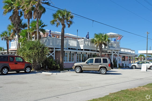

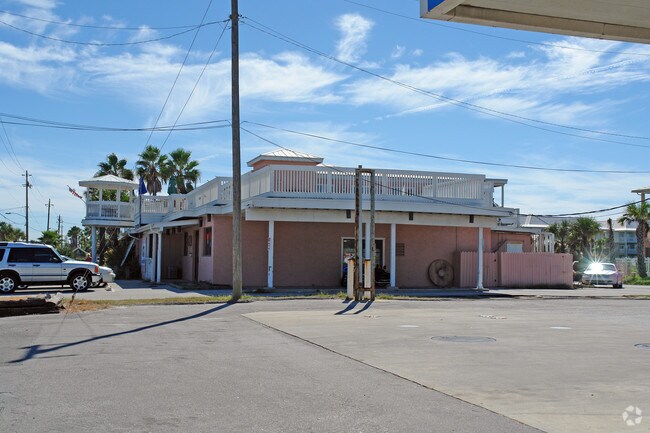
Property Detail
361 A1a Beach Blvd
Jacksonville, FL
10 PT OF GL 1 LYING W OF RD A1A - 200FT ON RD OR4111/883
163070-0000
ST. JOHNS
Restaurantbuilding
Florida
AO River or stream flood hazard areas, and areas with a 1% or greater chance of shallow flooding each year. These areas have a 26% chance of flooding over the life of a 30-year mortgage.
10
2025
0.71 AC
2026
St Johns County
021409
Jacksonville (Florida)
7,795 SF
NEARBY LISTINGS FOR SALE OR LEASE
DEMOGRAPHICS near 361 A1a Beach Blvd
1 mile
3 mile
5 mile
2025 Total Population
5,763
24,104
66,254
2030 Population
6,837
28,377
77,532
Pop Growth 2025-2030
+ 18.64%
+ 17.73%
+ 17.02%
Average Age
48
51
49
2025 Total Households
2,686
11,496
30,415
HH Growth 2025-2030
+ 18.91%
+ 18.19%
+ 17.57%
Median Household Inc
$99,742
$89,998
$77,936
Avg Household Size
2.10
2.10
2.10
2025 Avg HH Vehicles
2.00
2.00
2.00
Median Home Value
$701,162
$642,939
$485,899
Median Year Built
1992
1993
1992
Nearby Places
Map Layers
Map Styles
 Street
 Aerial
Layers
 Traffic
 Biking
Places
Listings with unknown addresses are not visible on the map
- Restaurants
- Banks
- Shops
- Fitness
- Groceries
Nearby Properties
Address
Land Use
TOTAL SIZE
Lot Size
Zoning
Address
Land Use
TOTAL SIZE
Lot Size
Zoning
279,494 SF
6.06 AC
Address
Land Use
TOTAL SIZE
Lot Size
Zoning
209,356 SF
12.88 AC
RG-O
Address
Land Use
TOTAL SIZE
Lot Size
Zoning
106,797 SF
10.80 AC
Address
Land Use
TOTAL SIZE
Lot Size
Zoning
130,186 SF
21.74 AC
CG
Address
Land Use
TOTAL SIZE
Lot Size
Zoning
127,090 SF
4.06 AC
R2
Address
Land Use
TOTAL SIZE
Lot Size
Zoning
7,133 SF
18.57 AC
RS3
Address
Land Use
TOTAL SIZE
Lot Size
Zoning
1,240 SF
29.76 AC
OR
Address
Land Use
TOTAL SIZE
Lot Size
Zoning
90,744 SF
5.47 AC
Address
Land Use
TOTAL SIZE
Lot Size
Zoning
7,021 SF
6.29 AC
OR
Address
Land Use
TOTAL SIZE
Lot Size
Zoning
73,318 SF
9.77 AC
RS3
Address
Land Use
TOTAL SIZE
Lot Size
Zoning
85,384 SF
5.42 AC
R2
Address
Land Use
TOTAL SIZE
Lot Size
Zoning
46,787 SF
3.04 AC
BU1A
Address
Land Use
TOTAL SIZE
Lot Size
Zoning
27,823 SF
1.95 AC
OR
Address
Land Use
TOTAL SIZE
Lot Size
Zoning
15,872 SF
124.49 AC
OR
Address
Land Use
TOTAL SIZE
Lot Size
Zoning
54,119 SF
2.03 AC
BU-1
Address
Land Use
TOTAL SIZE
Lot Size
Zoning
36.64 AC
RG-O
Address
Land Use
TOTAL SIZE
Lot Size
Zoning
27,461 SF
7.24 AC
Address
Land Use
TOTAL SIZE
Lot Size
Zoning
76,239 SF
1.07 AC
CM1
Address
Land Use
TOTAL SIZE
Lot Size
Zoning
27,185 SF
206.55 AC
PUD
Address
Land Use
TOTAL SIZE
Lot Size
Zoning
52,011 SF
11.51 AC
CG-B
Address
Land Use
TOTAL SIZE
Lot Size
Zoning
46,796 SF
1.36 AC
R2
Address
Land Use
TOTAL SIZE
Lot Size
Zoning
52,176 SF
7.86 AC
Address
Land Use
TOTAL SIZE
Lot Size
Zoning
25,453 SF
322.02 AC
OR
Address
Land Use
TOTAL SIZE
Lot Size
Zoning
20,618 SF
1.24 AC
BU-1A
Address
Land Use
TOTAL SIZE
Lot Size
Zoning
96,200 SF
7.76 AC
RG-O
Address
Land Use
TOTAL SIZE
Lot Size
Zoning
2,700 SF
4.20 AC
CM1
Address
Land Use
TOTAL SIZE
Lot Size
Zoning
9,945 SF
1.57 AC
Address
Land Use
TOTAL SIZE
Lot Size
Zoning
52,131 SF
6.50 AC
Address
Land Use
TOTAL SIZE
Lot Size
Zoning
15,700 SF
1.13 AC
RG-O
Address
Land Use
TOTAL SIZE
Lot Size
Zoning
16,270 SF
1 AC
The World's #1 Commercial Real Estate Marketplace
Connect with us
© 2026 CoStar Group
The information above has been obtained from sources believed reliable. While we do not doubt its accuracy we have not verified it and make no guarantee, warranty or representation about it. It is your responsibility to independently confirm its accuracy and completeness. Any projections, opinions, assumptions, or estimates used are for example only and do not represent the current or future performance of the property. The value of this transaction to you depends on tax and other factors which should be evaluated by your tax, financial, and legal advisors. You and your advisors should conduct a careful, independent investigation of the property to determine to your satisfaction the suitability of the property for your needs.