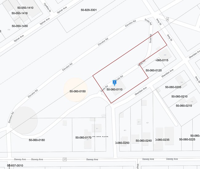
Property Record
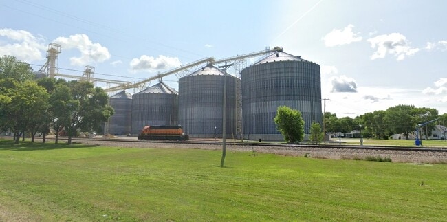
361 Dewey St, Maynard, MN 56260
Property Detail
361 Dewey St
Other Market Areas
SOUTH SIDE ADDITION LOTS 19, 20, 21, 22 & 23 BLOCK 1
50-060-0150
CHIPPEWA
Industrialgeneral
Minnesota
2025
19-23
2025
0.80 AC
950300
Minnesota South Area
NEARBY LISTINGS FOR SALE OR LEASE
-
-
View all Maynard listings for sale on LoopNet.com
DEMOGRAPHICS near 361 Dewey St
1 mile
3 mile
5 mile
2025 Total Population
352
490
750
2030 Population
351
483
735
Pop Growth 2025-2030
(0.28%)
(1.43%)
(2.00%)
Average Age
46
45
44
2025 Total Households
144
199
306
HH Growth 2025-2030
(0.69%)
(1.51%)
(1.96%)
Median Household Inc
$63,375
$65,769
$68,541
Avg Household Size
2.20
2.20
2.30
2025 Avg HH Vehicles
2.00
2.00
2.00
Median Home Value
$183,333
$192,423
$195,999
Median Year Built
1979
1974
1968
Nearby Places
Map Layers
Map Styles
 Street
 Aerial
Layers
 Traffic
 Biking
Places
Listings with unknown addresses are not visible on the map
- Restaurants
- Banks
- Shops
- Fitness
- Groceries
Nearby Properties
Address
Land Use
TOTAL SIZE
Lot Size
Zoning
Address
Land Use
TOTAL SIZE
Lot Size
Zoning
229.23 AC
Address
Land Use
TOTAL SIZE
Lot Size
Zoning
225.90 AC
Address
Land Use
TOTAL SIZE
Lot Size
Zoning
Address
Land Use
TOTAL SIZE
Lot Size
Zoning
157.79 AC
Address
Land Use
TOTAL SIZE
Lot Size
Zoning
Address
Land Use
TOTAL SIZE
Lot Size
Zoning
160 AC
Address
Land Use
TOTAL SIZE
Lot Size
Zoning
159.56 AC
Address
Land Use
TOTAL SIZE
Lot Size
Zoning
Address
Land Use
TOTAL SIZE
Lot Size
Zoning
161.57 AC
Address
Land Use
TOTAL SIZE
Lot Size
Zoning
160 AC
Address
Land Use
TOTAL SIZE
Lot Size
Zoning
148.34 AC
Address
Land Use
TOTAL SIZE
Lot Size
Zoning
Address
Land Use
TOTAL SIZE
Lot Size
Zoning
128.11 AC
Address
Land Use
TOTAL SIZE
Lot Size
Zoning
118.70 AC
Address
Land Use
TOTAL SIZE
Lot Size
Zoning
Address
Land Use
TOTAL SIZE
Lot Size
Zoning
Address
Land Use
TOTAL SIZE
Lot Size
Zoning
Address
Land Use
TOTAL SIZE
Lot Size
Zoning
117.25 AC
Address
Land Use
TOTAL SIZE
Lot Size
Zoning
110.30 AC
Address
Land Use
TOTAL SIZE
Lot Size
Zoning
113.18 AC
Address
Land Use
TOTAL SIZE
Lot Size
Zoning
101.90 AC
Address
Land Use
TOTAL SIZE
Lot Size
Zoning
111.56 AC
Address
Land Use
TOTAL SIZE
Lot Size
Zoning
83.40 AC
Address
Land Use
TOTAL SIZE
Lot Size
Zoning
104.29 AC
Address
Land Use
TOTAL SIZE
Lot Size
Zoning
90.87 AC
The World's #1 Commercial Real Estate Marketplace
Connect with us
© 2026 CoStar Group
The information above has been obtained from sources believed reliable. While we do not doubt its accuracy we have not verified it and make no guarantee, warranty or representation about it. It is your responsibility to independently confirm its accuracy and completeness. Any projections, opinions, assumptions, or estimates used are for example only and do not represent the current or future performance of the property. The value of this transaction to you depends on tax and other factors which should be evaluated by your tax, financial, and legal advisors. You and your advisors should conduct a careful, independent investigation of the property to determine to your satisfaction the suitability of the property for your needs.