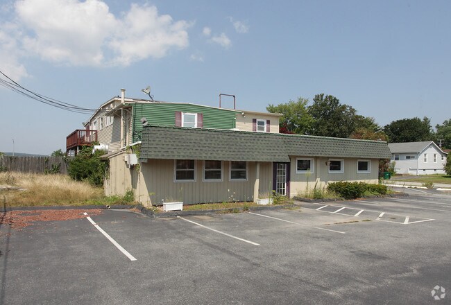
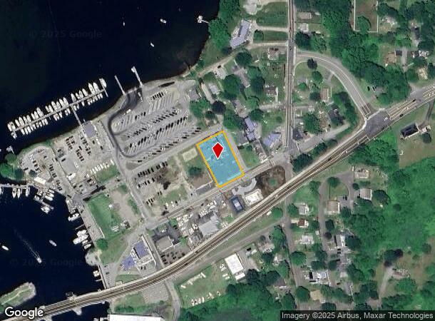
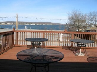
Property Record
361 Mago Point Way, Waterford, CT 06385
NEARBY LISTINGS FOR SALE OR LEASE
Property Detail
361 Mago Point Way
WATE-000149-000000-007064
New London
Commercialbuilding
Connecticut
X
7064
09011C0483J
0.58 AC
2025
New London
2025
Hartford
693300
Norwich-New London-Willimantic, CT
4,488 SF
DEMOGRAPHICS near 361 Mago Point Way
1 Mile
3 Mile
5 Mile
2024 Total Population
1,933
21,450
60,562
2029 Population
1,970
21,754
60,774
Pop Growth 2024-2029
+ 1.91%
+ 1.42%
+ 0.35%
Average Age
47
47
43
2024 Total Households
860
9,535
25,515
HH Growth 2024-2029
+ 2.09%
+ 1.43%
+ 0.36%
Median Household Inc
$94,907
$93,392
$78,721
Avg Household Size
2.20
2.10
2.20
2024 Avg HH Vehicles
2.00
2.00
2.00
Median Home Value
$361,637
$324,463
$313,040
Median Year Built
1949
1965
1962
Nearby Places
Map Layers
Map Styles
 Street
 Aerial
- Restaurants
- Banks
- Shops
- Fitness
- Groceries
PUBLIC TRANSPORTATION
COMMUTER RAIL
New London (Shore Line East - Shore Line East)
DRIVE
WALK
Distance
New London (Shore Line East - Shore Line East)
11 min
5.0 mi
Nearby Properties
Address
Land Use
TOTAL SIZE
Lot Size
Zoning
Address
Land Use
TOTAL SIZE
Lot Size
Zoning
525.72 AC
I-G
Address
Land Use
TOTAL SIZE
Lot Size
Zoning
Address
Land Use
TOTAL SIZE
Lot Size
Zoning
66.17 AC
LI
Address
Land Use
TOTAL SIZE
Lot Size
Zoning
296,000 SF
46.82 AC
C-T
Address
Land Use
TOTAL SIZE
Lot Size
Zoning
35.69 AC
SPD
Address
Land Use
TOTAL SIZE
Lot Size
Zoning
Address
Land Use
TOTAL SIZE
Lot Size
Zoning
26.44 AC
C-G
Address
Land Use
TOTAL SIZE
Lot Size
Zoning
68,774 SF
53.34 AC
C-T
Address
Land Use
TOTAL SIZE
Lot Size
Zoning
68,331 SF
9.50 AC
R-20
Address
Land Use
TOTAL SIZE
Lot Size
Zoning
Address
Land Use
TOTAL SIZE
Lot Size
Zoning
68,244 SF
25.67 AC
R-40
Address
Land Use
TOTAL SIZE
Lot Size
Zoning
79,469 SF
17.98 AC
IP-1
Address
Land Use
TOTAL SIZE
Lot Size
Zoning
21.08 AC
C-G
Address
Land Use
TOTAL SIZE
Lot Size
Zoning
68,045 SF
15.56 AC
IP-1
Address
Land Use
TOTAL SIZE
Lot Size
Zoning
62,878 SF
6.01 AC
CA
Address
Land Use
TOTAL SIZE
Lot Size
Zoning
2,328 SF
11.06 AC
R-MF
Address
Land Use
TOTAL SIZE
Lot Size
Zoning
55,906 SF
2.16 AC
CB
Address
Land Use
TOTAL SIZE
Lot Size
Zoning
Address
Land Use
TOTAL SIZE
Lot Size
Zoning
48,697 SF
3.83 AC
TC-80
Address
Land Use
TOTAL SIZE
Lot Size
Zoning
67,784 SF
5.53 AC
CA
Address
Land Use
TOTAL SIZE
Lot Size
Zoning
24,857 SF
4.68 AC
C-T
Address
Land Use
TOTAL SIZE
Lot Size
Zoning
10.79 AC
R40
Address
Land Use
TOTAL SIZE
Lot Size
Zoning
4.46 AC
C-G
Address
Land Use
TOTAL SIZE
Lot Size
Zoning
29,627 SF
20 AC
R-40
Address
Land Use
TOTAL SIZE
Lot Size
Zoning
82,326 SF
10.78 AC
R-MF
Address
Land Use
TOTAL SIZE
Lot Size
Zoning
117,333 SF
18.11 AC
I-G
Address
Land Use
TOTAL SIZE
Lot Size
Zoning
59,162 SF
7.22 AC
R-40
Address
Land Use
TOTAL SIZE
Lot Size
Zoning
3.29 AC
CB
Address
Land Use
TOTAL SIZE
Lot Size
Zoning
29,830 SF
4.85 AC
LI
Address
Land Use
TOTAL SIZE
Lot Size
Zoning
57,298 SF
2.13 AC
CA
The World's #1 Commercial Real Estate Marketplace
Connect with us
© 2026 CoStar Group
The information above has been obtained from sources believed reliable. While we do not doubt its accuracy we have not verified it and make no guarantee, warranty or representation about it. It is your responsibility to independently confirm its accuracy and completeness. Any projections, opinions, assumptions, or estimates used are for example only and do not represent the current or future performance of the property. The value of this transaction to you depends on tax and other factors which should be evaluated by your tax, financial, and legal advisors. You and your advisors should conduct a careful, independent investigation of the property to determine to your satisfaction the suitability of the property for your needs.