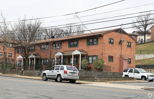
Property Record
361 Ridge Rd Se, Washington, DC 20019
NEARBY LISTINGS FOR SALE OR LEASE
Property Detail
361 Ridge Rd Se
Washington-Arlington-Alexandria, DC-VA-MD-WV
Fort Dupont Park
5422-0019
SQUARE 5422 LOT 0015 NBHD: FORT DUPONT PARK
Apartment
District of Columbia
X
District of Columbia
1100010039C
15
0
1.15 AC
2025
Fort Dupont
007703
Washington, DC
19,758 SF
DEMOGRAPHICS near 361 Ridge Rd Se
1 Mile
3 Mile
5 Mile
2024 Total Population
25,128
226,919
588,415
2029 Population
22,944
210,965
554,009
Pop Growth 2024-2029
(8.69%)
(7.03%)
(5.85%)
Average Age
39
38
38
2024 Total Households
10,900
95,727
254,885
HH Growth 2024-2029
(9.61%)
(7.89%)
(6.55%)
Median Household Inc
$47,424
$69,434
$77,800
Avg Household Size
2.20
2.20
2.20
2024 Avg HH Vehicles
1.00
1.00
1.00
Median Home Value
$401,108
$450,362
$427,338
Median Year Built
1956
1957
1966
Nearby Places
Map Layers
Map Styles
 Street
 Aerial
- Restaurants
- Banks
- Shops
- Fitness
- Groceries
PUBLIC TRANSPORTATION
TRANSIT/SUBWAY
Benning Road (Blue Line - Washington Metropolitan Area Transit Authority Metrorail (Metrorail), Silver Line - Washington Metropolitan Area Transit Authority Metrorail (Metrorail))
DRIVE
WALK
Distance
Benning Road (Blue Line - Washington Metropolitan Area Transit Authority Metrorail (Metrorail), Silver Line - Washington Metropolitan Area Transit Authority Metrorail (Metrorail))
2 min
19 min
1.0 mi
COMMUTER RAIL
Lead (Fredericksburg Line - Virginia Railway Express, Manassas Line - Virginia Railway Express)
DRIVE
WALK
Distance
Lead (Fredericksburg Line - Virginia Railway Express, Manassas Line - Virginia Railway Express)
7 min
4.0 mi
Union Station (Brunswick Line - Maryland Area Regional Commuter Trains (The MARC), Camden Line - Maryland Area Regional Commuter Trains (The MARC), Fredericksburg Line - Maryland Area Regional Commuter Trains (The MARC), Manassas Line - Maryland Area Regional Commuter Trains (The MARC), Penn Line - Maryland Area Regional Commuter Trains (The MARC), Red Line - Maryland Area Regional Commuter Trains (The MARC))
DRIVE
WALK
Distance
Union Station (Brunswick Line - Maryland Area Regional Commuter Trains (The MARC), Camden Line - Maryland Area Regional Commuter Trains (The MARC), Fredericksburg Line - Maryland Area Regional Commuter Trains (The MARC), Manassas Line - Maryland Area Regional Commuter Trains (The MARC), Penn Line - Maryland Area Regional Commuter Trains (The MARC), Red Line - Maryland Area Regional Commuter Trains (The MARC))
8 min
4.2 mi
AIRPORT
Ronald Reagan Washington Ntl
DRIVE
WALK
Distance
Ronald Reagan Washington Ntl
18 min
9.0 mi
Baltimore/Washington International Thurgood Marshall
DRIVE
WALK
Distance
Baltimore/Washington International Thurgood Marshall
43 min
28.7 mi
Washington Dulles International
DRIVE
WALK
Distance
Washington Dulles International
53 min
32.9 mi
Freight Ports
Port of Baltimore
DRIVE
WALK
Distance
Port of Baltimore
53 min
35.3 mi
Nearby Properties
Address
Land Use
TOTAL SIZE
Lot Size
Zoning
Address
Land Use
TOTAL SIZE
Lot Size
Zoning
58,289 SF
418.97 AC
MU-4;PDR-1
Address
Land Use
TOTAL SIZE
Lot Size
Zoning
2,369,428 SF
7.93 AC
MU-10;SEFC
Address
Land Use
TOTAL SIZE
Lot Size
Zoning
2,542,436 SF
6.39 AC
MU-2;MU-4;
Address
Land Use
TOTAL SIZE
Lot Size
Zoning
1,642,951 SF
95.12 AC
RF-1
Address
Land Use
TOTAL SIZE
Lot Size
Zoning
1,323,000 SF
3.36 AC
RA-2
Address
Land Use
TOTAL SIZE
Lot Size
Zoning
21.28 AC
GOV
Address
Land Use
TOTAL SIZE
Lot Size
Zoning
169.85 AC
R-2;RA-1;U
Address
Land Use
TOTAL SIZE
Lot Size
Zoning
812,092 SF
10.19 AC
UNZONED
Address
Land Use
TOTAL SIZE
Lot Size
Zoning
726,490 SF
3.84 AC
RA-2
Address
Land Use
TOTAL SIZE
Lot Size
Zoning
2,131,229 SF
144.34 AC
AG
Address
Land Use
TOTAL SIZE
Lot Size
Zoning
30,000 SF
819.17 AC
PDR-1;RA-1
Address
Land Use
TOTAL SIZE
Lot Size
Zoning
418,531 SF
2.48 AC
RF-1
Address
Land Use
TOTAL SIZE
Lot Size
Zoning
36.52 AC
HE-2;HE-3;
Address
Land Use
TOTAL SIZE
Lot Size
Zoning
236,535 SF
12.54 AC
R-2
Address
Land Use
TOTAL SIZE
Lot Size
Zoning
404,150 SF
1.34 AC
D-5
Address
Land Use
TOTAL SIZE
Lot Size
Zoning
190,000 SF
D-5
Address
Land Use
TOTAL SIZE
Lot Size
Zoning
4.80 AC
SEFC-4
Address
Land Use
TOTAL SIZE
Lot Size
Zoning
449,882 SF
2.32 AC
NMU-5A/H-H
Address
Land Use
TOTAL SIZE
Lot Size
Zoning
176.56 AC
HE-3;UNZON
Address
Land Use
TOTAL SIZE
Lot Size
Zoning
546,573 SF
3.78 AC
UNZONED
Address
Land Use
TOTAL SIZE
Lot Size
Zoning
503,712 SF
0.73 AC
D-5
Address
Land Use
TOTAL SIZE
Lot Size
Zoning
798,776 SF
2.55 AC
UNZONED
Address
Land Use
TOTAL SIZE
Lot Size
Zoning
359,410 SF
1.15 AC
D-5
Address
Land Use
TOTAL SIZE
Lot Size
Zoning
327,745 SF
9.39 AC
RF-1
Address
Land Use
TOTAL SIZE
Lot Size
Zoning
241,725 SF
4.71 AC
MU-7B;PDR-
Address
Land Use
TOTAL SIZE
Lot Size
Zoning
424,800 SF
1.64 AC
NMU-5A/H-R
Address
Land Use
TOTAL SIZE
Lot Size
Zoning
552,757 SF
2.11 AC
D-5
Address
Land Use
TOTAL SIZE
Lot Size
Zoning
234,260 SF
1.39 AC
MU-4
Address
Land Use
TOTAL SIZE
Lot Size
Zoning
62.03 AC
UNZONED
Address
Land Use
TOTAL SIZE
Lot Size
Zoning
18,570 SF
1.78 AC
R-3
The World's #1 Commercial Real Estate Marketplace
Connect with us
© 2025 CoStar Group
The information above has been obtained from sources believed reliable. While we do not doubt its accuracy we have not verified it and make no guarantee, warranty or representation about it. It is your responsibility to independently confirm its accuracy and completeness. Any projections, opinions, assumptions, or estimates used are for example only and do not represent the current or future performance of the property. The value of this transaction to you depends on tax and other factors which should be evaluated by your tax, financial, and legal advisors. You and your advisors should conduct a careful, independent investigation of the property to determine to your satisfaction the suitability of the property for your needs.