Property Record
3611 128Th Ave Sw, Belfield, ND 58622


NEARBY LISTINGS FOR SALE OR LEASE
-
-
View all Belfield listings for sale on LoopNet.com
Property Detail
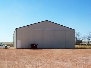
3611 128Th Ave Sw
38000006939100
TRACT IN NE4 7.55 ACRES 3-139-99
Commercialnec
Stark
X
North Dakota
38089C0125F
7.55 AC
2024
North Dakota Area
2024
Other Market Areas
964000
Dickinson, ND
4,320 SF
DEMOGRAPHICS near 3611 128Th Ave Sw
1 Mile
3 Mile
5 Mile
2024 Total Population
23
976
1,051
2029 Population
21
939
1,012
Pop Growth 2024-2029
(8.70%)
(3.79%)
(3.71%)
Average Age
39
38
38
2024 Total Households
9
395
425
HH Growth 2024-2029
(11.11%)
(4.05%)
(3.76%)
Median Household Inc
$99,999
$68,788
$69,044
Avg Household Size
2.70
2.50
2.50
2024 Avg HH Vehicles
3.00
2.00
2.00
Median Home Value
$274,999
$193,819
$197,848
Median Year Built
1979
1970
1971
Nearby Places
Map Layers
Map Styles
 Street
 Aerial
- Restaurants
- Banks
- Shops
- Fitness
- Groceries
Nearby Properties
Address
Land Use
TOTAL SIZE
Lot Size
Zoning
Address
Land Use
TOTAL SIZE
Lot Size
Zoning
22,500 SF
34.52 AC
Address
Land Use
TOTAL SIZE
Lot Size
Zoning
12,002 SF
19.81 AC
Address
Land Use
TOTAL SIZE
Lot Size
Zoning
7,176 SF
1.30 AC
Address
Land Use
TOTAL SIZE
Lot Size
Zoning
9,620 SF
1.30 AC
Address
Land Use
TOTAL SIZE
Lot Size
Zoning
12,928 SF
8.34 AC
Address
Land Use
TOTAL SIZE
Lot Size
Zoning
7,500 SF
3.60 AC
Address
Land Use
TOTAL SIZE
Lot Size
Zoning
12,000 SF
4.16 AC
Address
Land Use
TOTAL SIZE
Lot Size
Zoning
7,800 SF
5.40 AC
Address
Land Use
TOTAL SIZE
Lot Size
Zoning
8,260 SF
1.38 AC
Address
Land Use
TOTAL SIZE
Lot Size
Zoning
6,600 SF
3.82 AC
Address
Land Use
TOTAL SIZE
Lot Size
Zoning
9,800 SF
0.40 AC
Address
Land Use
TOTAL SIZE
Lot Size
Zoning
9,600 SF
5 AC
Address
Land Use
TOTAL SIZE
Lot Size
Zoning
16.79 AC
Address
Land Use
TOTAL SIZE
Lot Size
Zoning
8,000 SF
5 AC
Address
Land Use
TOTAL SIZE
Lot Size
Zoning
7,872 SF
1.75 AC
Address
Land Use
TOTAL SIZE
Lot Size
Zoning
17,600 SF
0.32 AC
Address
Land Use
TOTAL SIZE
Lot Size
Zoning
9,600 SF
3 AC
Address
Land Use
TOTAL SIZE
Lot Size
Zoning
10,688 SF
1.40 AC
Address
Land Use
TOTAL SIZE
Lot Size
Zoning
Address
Land Use
TOTAL SIZE
Lot Size
Zoning
Address
Land Use
TOTAL SIZE
Lot Size
Zoning
2,520 SF
0.53 AC
Address
Land Use
TOTAL SIZE
Lot Size
Zoning
2,240 SF
0.32 AC
Address
Land Use
TOTAL SIZE
Lot Size
Zoning
2,240 SF
0.32 AC
Address
Land Use
TOTAL SIZE
Lot Size
Zoning
4,080 SF
4.50 AC
Address
Land Use
TOTAL SIZE
Lot Size
Zoning
7,800 SF
57.45 AC
Address
Land Use
TOTAL SIZE
Lot Size
Zoning
4,726 SF
0.24 AC
Address
Land Use
TOTAL SIZE
Lot Size
Zoning
5,500 SF
0.37 AC
Address
Land Use
TOTAL SIZE
Lot Size
Zoning
77.74 AC
Address
Land Use
TOTAL SIZE
Lot Size
Zoning
10,800 SF
6.62 AC
The World's #1 Commercial Real Estate Marketplace
Connect with us
© 2026 CoStar Group
The information above has been obtained from sources believed reliable. While we do not doubt its accuracy we have not verified it and make no guarantee, warranty or representation about it. It is your responsibility to independently confirm its accuracy and completeness. Any projections, opinions, assumptions, or estimates used are for example only and do not represent the current or future performance of the property. The value of this transaction to you depends on tax and other factors which should be evaluated by your tax, financial, and legal advisors. You and your advisors should conduct a careful, independent investigation of the property to determine to your satisfaction the suitability of the property for your needs.