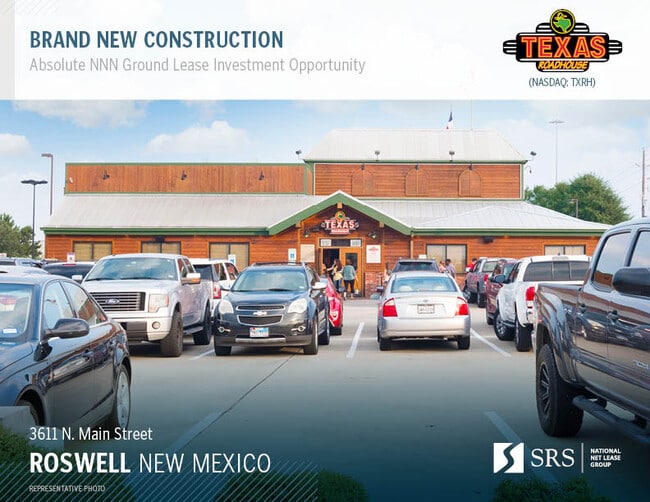
Property Record
3611 N Main St, Roswell, NM 88201

NEARBY LISTINGS FOR SALE OR LEASE
Property Detail
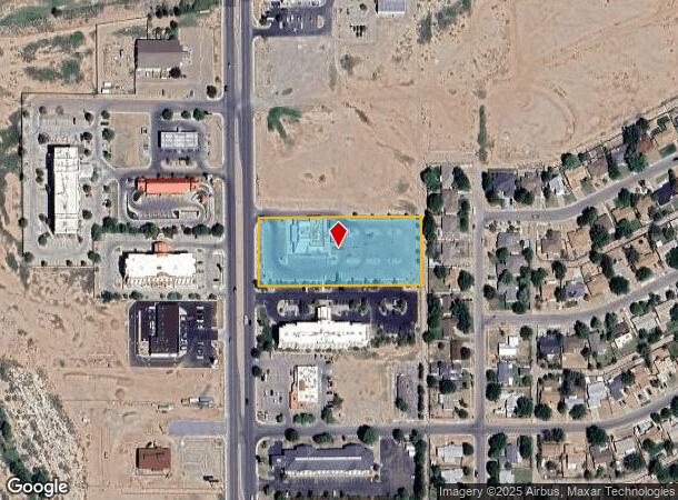
3611 N Main St
Other Market Areas
Riverside North
Roswell, NM
SUBD: RIVERSIDE NORTH SUBDIVISION SUMMARY PLAT NO. 5 LOT: 2 S: 16 T: 10S R: 24E DOC# 202205865 SWD
4136058032363000000
Chaves
Realpropertynec
New Mexico
2024
2
2025
2.21 AC
001002
New Mexico South Area
7,768 SF
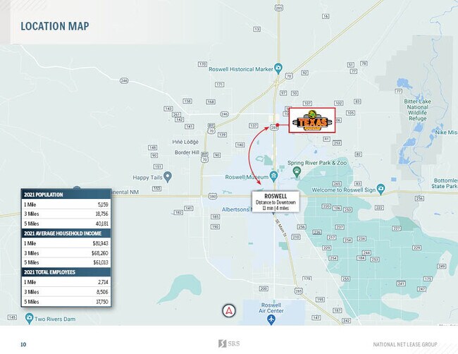
DEMOGRAPHICS near 3611 N Main St
1 Mile
3 Mile
5 Mile
2024 Total Population
5,485
19,505
41,001
2029 Population
5,365
19,173
40,462
Pop Growth 2024-2029
(2.19%)
(1.70%)
(1.31%)
Average Age
40
40
39
2024 Total Households
2,030
7,538
15,541
HH Growth 2024-2029
(2.32%)
(1.80%)
(1.43%)
Median Household Inc
$83,766
$60,492
$50,008
Avg Household Size
2.60
2.50
2.60
2024 Avg HH Vehicles
2.00
2.00
2.00
Median Home Value
$191,062
$181,933
$152,767
Median Year Built
1979
1975
1970
Nearby Places
Map Layers
Map Styles
 Street
 Aerial
- Restaurants
- Banks
- Shops
- Fitness
- Groceries
PUBLIC TRANSPORTATION
AIRPORT
Roswell Air Center
DRIVE
WALK
Distance
Roswell Air Center
22 min
10.1 mi
Freight Ports
Tulsa Port Of Catoosa
DRIVE
WALK
Distance
Tulsa Port Of Catoosa
635 min
586.0 mi
SALE & LEASE HISTORY
LISTING DATE
SALE/LEASE

Feb 23, 2022
For Sale
Nearby Properties
Address
Land Use
TOTAL SIZE
Lot Size
Zoning
Address
Land Use
TOTAL SIZE
Lot Size
Zoning
10,644 SF
5.81 AC
COMMUNITY
Address
Land Use
TOTAL SIZE
Lot Size
Zoning
23.93 AC
RESIDENTIA
Address
Land Use
TOTAL SIZE
Lot Size
Zoning
230,872 SF
9.40 AC
COMMUNITY
Address
Land Use
TOTAL SIZE
Lot Size
Zoning
2.58 AC
COMMUNITY
Address
Land Use
TOTAL SIZE
Lot Size
Zoning
22.08 AC
Address
Land Use
TOTAL SIZE
Lot Size
Zoning
150.96 AC
RESIDENTIA
Address
Land Use
TOTAL SIZE
Lot Size
Zoning
56.23 AC
Address
Land Use
TOTAL SIZE
Lot Size
Zoning
6.47 AC
RESIDENTIA
Address
Land Use
TOTAL SIZE
Lot Size
Zoning
203,209 SF
22.13 AC
COMMUNITY
Address
Land Use
TOTAL SIZE
Lot Size
Zoning
9.05 AC
Address
Land Use
TOTAL SIZE
Lot Size
Zoning
Address
Land Use
TOTAL SIZE
Lot Size
Zoning
134,448 SF
15.85 AC
COMMUNITY
Address
Land Use
TOTAL SIZE
Lot Size
Zoning
20.23 AC
RESIDENTIA
Address
Land Use
TOTAL SIZE
Lot Size
Zoning
39,382 SF
1.90 AC
COMMUNITY
Address
Land Use
TOTAL SIZE
Lot Size
Zoning
29.09 AC
RESIDENTIA
Address
Land Use
TOTAL SIZE
Lot Size
Zoning
6.48 AC
RESIDENTIA
Address
Land Use
TOTAL SIZE
Lot Size
Zoning
39,383 SF
2.11 AC
COMMUNITY
Address
Land Use
TOTAL SIZE
Lot Size
Zoning
1,126 SF
0.14 AC
RESIDENTIA
Address
Land Use
TOTAL SIZE
Lot Size
Zoning
54.27 AC
RESIDENTIA
Address
Land Use
TOTAL SIZE
Lot Size
Zoning
59,672 SF
3.04 AC
COMMUNITY
Address
Land Use
TOTAL SIZE
Lot Size
Zoning
50,281 SF
1.47 AC
COMMUNITY
Address
Land Use
TOTAL SIZE
Lot Size
Zoning
238,267 SF
18.30 AC
COMMUNITY
Address
Land Use
TOTAL SIZE
Lot Size
Zoning
12,689 SF
4.86 AC
RESIDENTIA
Address
Land Use
TOTAL SIZE
Lot Size
Zoning
9.39 AC
RESIDENTIA
Address
Land Use
TOTAL SIZE
Lot Size
Zoning
21,970 SF
2.28 AC
LIGHT INDU
Address
Land Use
TOTAL SIZE
Lot Size
Zoning
5 AC
RESIDENTIA
Address
Land Use
TOTAL SIZE
Lot Size
Zoning
14,074 SF
1.70 AC
CENTRAL BU
Address
Land Use
TOTAL SIZE
Lot Size
Zoning
92,983 SF
6.39 AC
COMMUNITY
Address
Land Use
TOTAL SIZE
Lot Size
Zoning
33,201 SF
4.27 AC
COMMUNITY
Address
Land Use
TOTAL SIZE
Lot Size
Zoning
23,576 SF
3.57 AC
COMMUNITY
The World's #1 Commercial Real Estate Marketplace
Connect with us
© 2025 CoStar Group
The information above has been obtained from sources believed reliable. While we do not doubt its accuracy we have not verified it and make no guarantee, warranty or representation about it. It is your responsibility to independently confirm its accuracy and completeness. Any projections, opinions, assumptions, or estimates used are for example only and do not represent the current or future performance of the property. The value of this transaction to you depends on tax and other factors which should be evaluated by your tax, financial, and legal advisors. You and your advisors should conduct a careful, independent investigation of the property to determine to your satisfaction the suitability of the property for your needs.