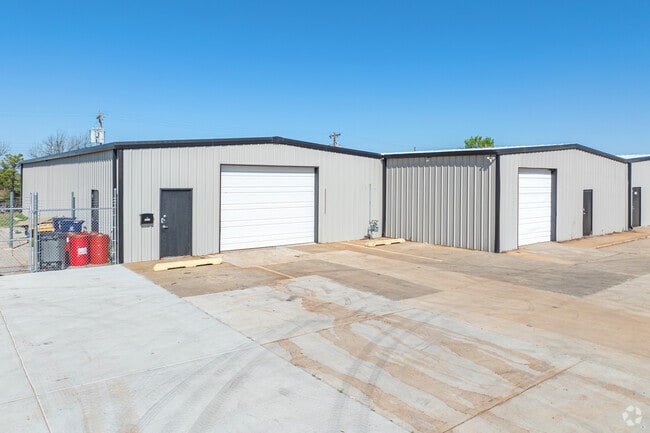
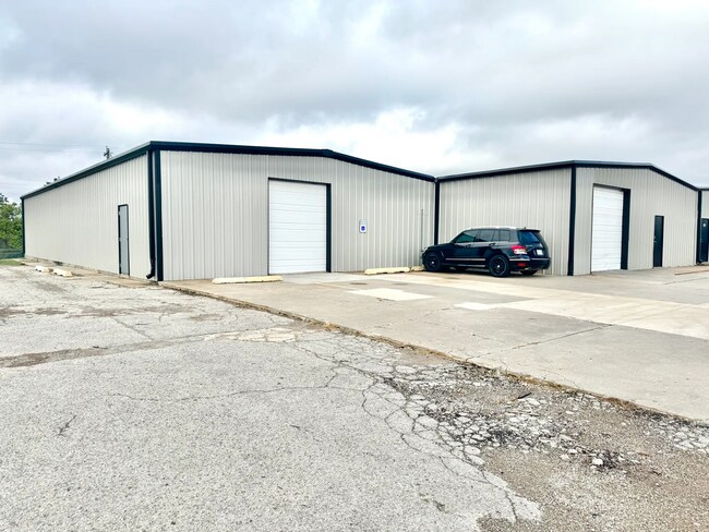
Property Record
3609 S High Ave, Oklahoma City, OK 73129

NEARBY LISTINGS FOR SALE OR LEASE
Property Detail
3609 S High Ave
Oklahoma City, OK
Phelans Addition
095118600
PHELANS ADDITION 008 000 S8FT LOT 6 ALL LOTS 7 THRU 11
Lightindustrial
Oklahoma
X
Oklahoma
40109C0315H
6-11
2023
0.40 AC
2024
South
104800
Oklahoma City
6,920 SF
DEMOGRAPHICS near 3609 S High Ave
1 Mile
3 Mile
5 Mile
2024 Total Population
8,506
74,257
230,474
2029 Population
8,731
76,596
238,526
Pop Growth 2024-2029
+ 2.65%
+ 3.15%
+ 3.49%
Average Age
33
34
35
2024 Total Households
2,824
26,506
88,354
HH Growth 2024-2029
+ 2.73%
+ 3.15%
+ 3.61%
Median Household Inc
$36,997
$39,360
$44,505
Avg Household Size
2.90
2.70
2.50
2024 Avg HH Vehicles
2.00
2.00
2.00
Median Home Value
$62,510
$73,144
$104,870
Median Year Built
1958
1965
1968
Nearby Places
Map Layers
Map Styles
 Street
 Aerial
- Restaurants
- Banks
- Shops
- Fitness
- Groceries
PUBLIC TRANSPORTATION
COMMUTER RAIL
Oklahoma City (Heartland Flyer - Amtrak)
DRIVE
WALK
Distance
Oklahoma City (Heartland Flyer - Amtrak)
6 min
3.5 mi
AIRPORT
Will Rogers World
DRIVE
WALK
Distance
Will Rogers World
20 min
8.5 mi
Freight Ports
Tulsa Port Of Catoosa
DRIVE
WALK
Distance
Tulsa Port Of Catoosa
137 min
125.6 mi
SALE & LEASE HISTORY
LISTING DATE
SALE/LEASE

Dec 04, 2023
For Lease
Nearby Properties
Address
Land Use
TOTAL SIZE
Lot Size
Zoning
Address
Land Use
TOTAL SIZE
Lot Size
Zoning
3,029,769 SF
7.21 AC
DBD
Address
Land Use
TOTAL SIZE
Lot Size
Zoning
52,331 SF
2.72 AC
DBD
Address
Land Use
TOTAL SIZE
Lot Size
Zoning
64,658 SF
1.86 AC
SPUD
Address
Land Use
TOTAL SIZE
Lot Size
Zoning
303,589 SF
7.17 AC
PUD
Address
Land Use
TOTAL SIZE
Lot Size
Zoning
382,618 SF
5.13 AC
BC
Address
Land Use
TOTAL SIZE
Lot Size
Zoning
281,052 SF
1.89 AC
DBD
Address
Land Use
TOTAL SIZE
Lot Size
Zoning
42,450 SF
0.32 AC
BC
Address
Land Use
TOTAL SIZE
Lot Size
Zoning
279,464 SF
1.49 AC
DBD
Address
Land Use
TOTAL SIZE
Lot Size
Zoning
188,121 SF
0.83 AC
BC
Address
Land Use
TOTAL SIZE
Lot Size
Zoning
344,045 SF
0.55 AC
DBD
Address
Land Use
TOTAL SIZE
Lot Size
Zoning
502,508 SF
2.27 AC
DBD
Address
Land Use
TOTAL SIZE
Lot Size
Zoning
621,489 SF
3.10 AC
DBD
Address
Land Use
TOTAL SIZE
Lot Size
Zoning
296,429 SF
33.05 AC
I-2
Address
Land Use
TOTAL SIZE
Lot Size
Zoning
312,675 SF
25.01 AC
Address
Land Use
TOTAL SIZE
Lot Size
Zoning
150,272 SF
1.54 AC
DBD
Address
Land Use
TOTAL SIZE
Lot Size
Zoning
0.42 AC
BC
Address
Land Use
TOTAL SIZE
Lot Size
Zoning
123,956 SF
0.73 AC
DBD
Address
Land Use
TOTAL SIZE
Lot Size
Zoning
152,302 SF
14 AC
SPUD
Address
Land Use
TOTAL SIZE
Lot Size
Zoning
460,398 SF
0.69 AC
DBD
Address
Land Use
TOTAL SIZE
Lot Size
Zoning
496,495 SF
2.02 AC
DBD
Address
Land Use
TOTAL SIZE
Lot Size
Zoning
104,100 SF
2.41 AC
PUD
Address
Land Use
TOTAL SIZE
Lot Size
Zoning
85,949 SF
0.50 AC
BC
Address
Land Use
TOTAL SIZE
Lot Size
Zoning
110,937 SF
0.55 AC
BC
Address
Land Use
TOTAL SIZE
Lot Size
Zoning
392,100 SF
7.87 AC
I-2
Address
Land Use
TOTAL SIZE
Lot Size
Zoning
296,700 SF
9.17 AC
I-2
Address
Land Use
TOTAL SIZE
Lot Size
Zoning
197,130 SF
0.64 AC
BC
Address
Land Use
TOTAL SIZE
Lot Size
Zoning
501,811 SF
29.33 AC
I-2
Address
Land Use
TOTAL SIZE
Lot Size
Zoning
211,642 SF
15.17 AC
I-2
Address
Land Use
TOTAL SIZE
Lot Size
Zoning
65,009 SF
8.72 AC
SPUD
Address
Land Use
TOTAL SIZE
Lot Size
Zoning
172,136 SF
8.46 AC
R-4
The World's #1 Commercial Real Estate Marketplace
Connect with us
© 2025 CoStar Group
The information above has been obtained from sources believed reliable. While we do not doubt its accuracy we have not verified it and make no guarantee, warranty or representation about it. It is your responsibility to independently confirm its accuracy and completeness. Any projections, opinions, assumptions, or estimates used are for example only and do not represent the current or future performance of the property. The value of this transaction to you depends on tax and other factors which should be evaluated by your tax, financial, and legal advisors. You and your advisors should conduct a careful, independent investigation of the property to determine to your satisfaction the suitability of the property for your needs.