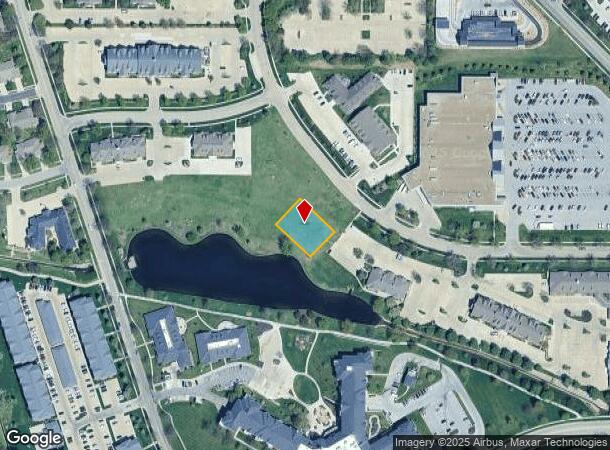
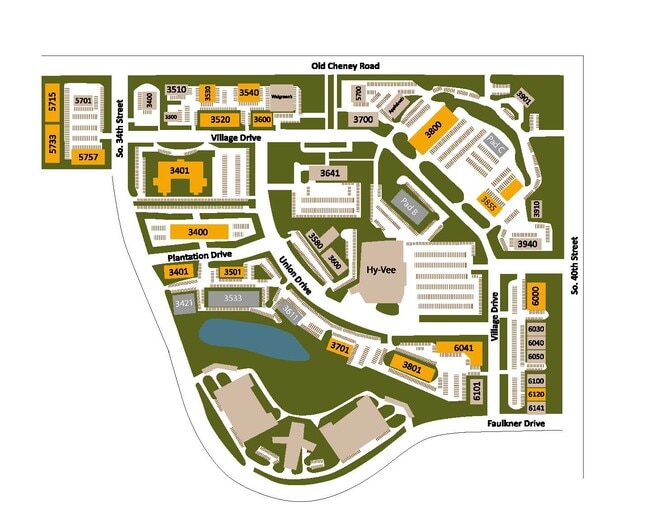
Property Record
3611 Union Dr, Lincoln, NE 68516

Current Lease Availabilities
NEARBY LISTINGS FOR SALE OR LEASE
Property Detail
3611 Union Dr
Lincoln, NE
Williamsburg Village North 37Th Addition
16-18-251-004-000
WILLIAMSBURG VILLAGE NORTH 37TH ADDITION, LOT 4
Commercialacreage
Lancaster
AE
Nebraska
31109C0318F
4
2024
0.33 AC
2025
Far South
003708
Lincoln
DEMOGRAPHICS near 3611 Union Dr
1 Mile
3 Mile
5 Mile
2024 Total Population
14,424
80,326
175,730
2029 Population
14,859
82,776
182,061
Pop Growth 2024-2029
+ 3.02%
+ 3.05%
+ 3.60%
Average Age
40
40
39
2024 Total Households
6,051
33,125
73,583
HH Growth 2024-2029
+ 3.11%
+ 3.12%
+ 3.75%
Median Household Inc
$72,876
$81,047
$68,007
Avg Household Size
2.40
2.40
2.30
2024 Avg HH Vehicles
2.00
2.00
2.00
Median Home Value
$267,535
$266,851
$259,544
Median Year Built
1987
1983
1978
Nearby Places
- Restaurants
- Banks
- Shops
- Fitness
- Groceries
PUBLIC TRANSPORTATION
COMMUTER RAIL
Lincoln Amtrak Station (California Zephyr - Amtrak)
DRIVE
WALK
Distance
Lincoln Amtrak Station (California Zephyr - Amtrak)
15 min
6.9 mi
AIRPORT
Lincoln
DRIVE
WALK
Distance
Lincoln
20 min
11.7 mi
Freight Ports
Tulsa Port Of Catoosa
DRIVE
WALK
Distance
Tulsa Port Of Catoosa
463 min
388.0 mi
Nearby Properties
Address
Land Use
TOTAL SIZE
Lot Size
Zoning
Address
Land Use
TOTAL SIZE
Lot Size
Zoning
329,069 SF
30 AC
R6
Address
Land Use
TOTAL SIZE
Lot Size
Zoning
48,378 SF
9.53 AC
R5
Address
Land Use
TOTAL SIZE
Lot Size
Zoning
213,738 SF
14.97 AC
B5
Address
Land Use
TOTAL SIZE
Lot Size
Zoning
185,015 SF
38.72 AC
AGR
Address
Land Use
TOTAL SIZE
Lot Size
Zoning
75,371 SF
12.46 AC
R3
Address
Land Use
TOTAL SIZE
Lot Size
Zoning
188,540 SF
4.57 AC
Address
Land Use
TOTAL SIZE
Lot Size
Zoning
126,172 SF
5.46 AC
B2
Address
Land Use
TOTAL SIZE
Lot Size
Zoning
234,103 SF
13.56 AC
R2
Address
Land Use
TOTAL SIZE
Lot Size
Zoning
172,989 SF
6.16 AC
Address
Land Use
TOTAL SIZE
Lot Size
Zoning
35,972 SF
10.13 AC
O3
Address
Land Use
TOTAL SIZE
Lot Size
Zoning
44,957 SF
7.93 AC
R4
Address
Land Use
TOTAL SIZE
Lot Size
Zoning
90,362 SF
2.53 AC
B3
Address
Land Use
TOTAL SIZE
Lot Size
Zoning
40,602 SF
7.07 AC
B2
Address
Land Use
TOTAL SIZE
Lot Size
Zoning
57,434 SF
15.62 AC
R4
Address
Land Use
TOTAL SIZE
Lot Size
Zoning
169,890 SF
3.05 AC
O3
Address
Land Use
TOTAL SIZE
Lot Size
Zoning
32,854 SF
22.09 AC
NULL
Address
Land Use
TOTAL SIZE
Lot Size
Zoning
81,149 SF
6.46 AC
R5
Address
Land Use
TOTAL SIZE
Lot Size
Zoning
33,983 SF
23.08 AC
R4
Address
Land Use
TOTAL SIZE
Lot Size
Zoning
22,324 SF
16.59 AC
NULL
Address
Land Use
TOTAL SIZE
Lot Size
Zoning
14,637 SF
18.90 AC
NULL
Address
Land Use
TOTAL SIZE
Lot Size
Zoning
16,284 SF
8.77 AC
NULL
Address
Land Use
TOTAL SIZE
Lot Size
Zoning
39,968 SF
13.41 AC
NULL
Address
Land Use
TOTAL SIZE
Lot Size
Zoning
67,029 SF
17.26 AC
R3
Address
Land Use
TOTAL SIZE
Lot Size
Zoning
131,049 SF
78.38 AC
P
Address
Land Use
TOTAL SIZE
Lot Size
Zoning
86,718 SF
7.16 AC
NULL
Address
Land Use
TOTAL SIZE
Lot Size
Zoning
63,298 SF
10.15 AC
R1
Address
Land Use
TOTAL SIZE
Lot Size
Zoning
78,993 SF
3.56 AC
H4
Address
Land Use
TOTAL SIZE
Lot Size
Zoning
68,764 SF
10.45 AC
R3
Address
Land Use
TOTAL SIZE
Lot Size
Zoning
101,990 SF
5.38 AC
R4
Address
Land Use
TOTAL SIZE
Lot Size
Zoning
111,178 SF
15.53 AC
O3
The World's #1 Commercial Real Estate Marketplace
Connect with us
© 2025 CoStar Group
The information above has been obtained from sources believed reliable. While we do not doubt its accuracy we have not verified it and make no guarantee, warranty or representation about it. It is your responsibility to independently confirm its accuracy and completeness. Any projections, opinions, assumptions, or estimates used are for example only and do not represent the current or future performance of the property. The value of this transaction to you depends on tax and other factors which should be evaluated by your tax, financial, and legal advisors. You and your advisors should conduct a careful, independent investigation of the property to determine to your satisfaction the suitability of the property for your needs.