Property Record
36115 E Lake Rd, Palm Harbor, FL 34685

Current Lease Availabilities
NEARBY LISTINGS FOR SALE OR LEASE
Property Detail
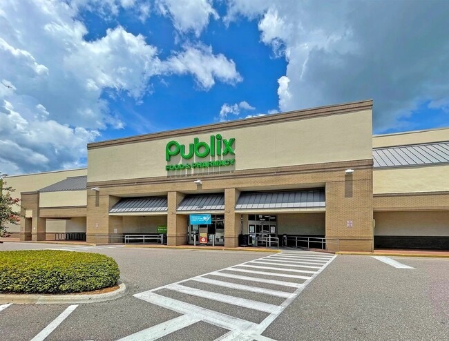
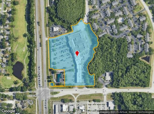
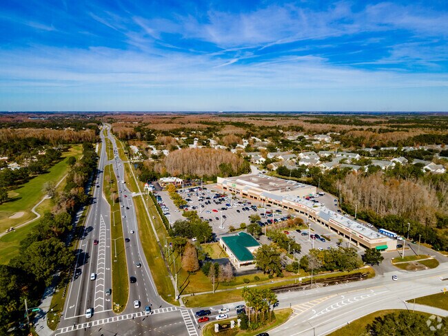
36115 E Lake Rd
Tampa-St. Petersburg-Clearwater, FL
Publix At Brooker Creek
27-27-16-73181-001-0010
PUBLIX AT BROOKER CREEK BLK 1, LOT 1
Regionalshoppingcenterormallwithanchorstore
Pinellas
A
Florida
12103C0077G
1
2024
9.67 AC
2025
North Pinellas
027333
Tampa/St Petersburg
86,470 SF
DEMOGRAPHICS near 36115 E Lake Rd
1 Mile
3 Mile
5 Mile
2024 Total Population
7,731
40,801
127,880
2029 Population
7,633
40,781
128,725
Pop Growth 2024-2029
(1.27%)
(0.05%)
+ 0.66%
Average Age
47
49
46
2024 Total Households
3,229
17,903
54,856
HH Growth 2024-2029
(1.64%)
(0.16%)
+ 0.41%
Median Household Inc
$78,935
$78,897
$75,559
Avg Household Size
2.30
2.20
2.30
2024 Avg HH Vehicles
2.00
2.00
2.00
Median Home Value
$409,753
$383,320
$355,699
Median Year Built
1989
1988
1986
Nearby Places
Map Layers
Map Styles
 Street
 Aerial
- Restaurants
- Banks
- Shops
- Fitness
- Groceries
PUBLIC TRANSPORTATION
AIRPORT
Tampa International
DRIVE
WALK
Distance
Tampa International
33 min
18.2 mi
St Pete-Clearwater International
DRIVE
WALK
Distance
St Pete-Clearwater International
34 min
18.3 mi
Freight Ports
Port of Tampa Bay
DRIVE
WALK
Distance
Port of Tampa Bay
46 min
26.6 mi
Nearby Properties
Address
Land Use
TOTAL SIZE
Lot Size
Zoning
Address
Land Use
TOTAL SIZE
Lot Size
Zoning
462,206 SF
30.26 AC
RPD5
Address
Land Use
TOTAL SIZE
Lot Size
Zoning
322,856 SF
70.93 AC
RPD5
Address
Land Use
TOTAL SIZE
Lot Size
Zoning
286,650 SF
23.36 AC
RPD5
Address
Land Use
TOTAL SIZE
Lot Size
Zoning
233,620 SF
14.13 AC
RPD5
Address
Land Use
TOTAL SIZE
Lot Size
Zoning
304,142 SF
12.19 AC
RPD5
Address
Land Use
TOTAL SIZE
Lot Size
Zoning
6,066 SF
284.52 AC
AE
Address
Land Use
TOTAL SIZE
Lot Size
Zoning
258,403 SF
10.62 AC
RPD5
Address
Land Use
TOTAL SIZE
Lot Size
Zoning
188,845 SF
33.69 AC
RPD5
Address
Land Use
TOTAL SIZE
Lot Size
Zoning
294,022 SF
15.75 AC
RPD5
Address
Land Use
TOTAL SIZE
Lot Size
Zoning
111,569 SF
62.80 AC
RPD251
Address
Land Use
TOTAL SIZE
Lot Size
Zoning
91,644 SF
29.39 AC
RPD25
Address
Land Use
TOTAL SIZE
Lot Size
Zoning
92,511 SF
18.39 AC
RPD75
Address
Land Use
TOTAL SIZE
Lot Size
Zoning
50,741 SF
9.85 AC
RPD5
Address
Land Use
TOTAL SIZE
Lot Size
Zoning
117,262 SF
15.32 AC
CP1
Address
Land Use
TOTAL SIZE
Lot Size
Zoning
118,599 SF
9.06 AC
C2
Address
Land Use
TOTAL SIZE
Lot Size
Zoning
76,996 SF
7.42 AC
C2
Address
Land Use
TOTAL SIZE
Lot Size
Zoning
102,523 SF
15.66 AC
RPD251
Address
Land Use
TOTAL SIZE
Lot Size
Zoning
39,100 SF
3.76 AC
C2
Address
Land Use
TOTAL SIZE
Lot Size
Zoning
39,462 SF
9.88 AC
AE
Address
Land Use
TOTAL SIZE
Lot Size
Zoning
490.93 AC
PRM
Address
Land Use
TOTAL SIZE
Lot Size
Zoning
64,894 SF
5.62 AC
CP1
Address
Land Use
TOTAL SIZE
Lot Size
Zoning
50,722 SF
6.04 AC
CP1
Address
Land Use
TOTAL SIZE
Lot Size
Zoning
641.61 AC
PC
Address
Land Use
TOTAL SIZE
Lot Size
Zoning
48,044 SF
4.86 AC
CP1
Address
Land Use
TOTAL SIZE
Lot Size
Zoning
51,331 SF
1.39 AC
P1
Address
Land Use
TOTAL SIZE
Lot Size
Zoning
25,645 SF
210.26 AC
PRM
Address
Land Use
TOTAL SIZE
Lot Size
Zoning
53,446 SF
4.75 AC
Address
Land Use
TOTAL SIZE
Lot Size
Zoning
26,531 SF
9.60 AC
RPD251
Address
Land Use
TOTAL SIZE
Lot Size
Zoning
28,973 SF
14.44 AC
RPD251
The World's #1 Commercial Real Estate Marketplace
Connect with us
© 2026 CoStar Group
The information above has been obtained from sources believed reliable. While we do not doubt its accuracy we have not verified it and make no guarantee, warranty or representation about it. It is your responsibility to independently confirm its accuracy and completeness. Any projections, opinions, assumptions, or estimates used are for example only and do not represent the current or future performance of the property. The value of this transaction to you depends on tax and other factors which should be evaluated by your tax, financial, and legal advisors. You and your advisors should conduct a careful, independent investigation of the property to determine to your satisfaction the suitability of the property for your needs.