Property Record
3612 Powhatan Rd, Clayton, NC 27527
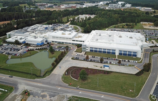

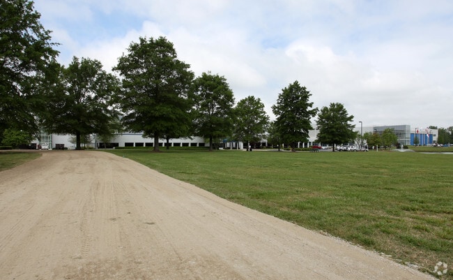
Property Detail
3612 Powhatan Rd
05E99010G
RECOMBINATION PLAT FOR NOVO 75/57
Scientificpharmaceuticalmedicalresearchfacility
Johnston
IND
North Carolina
B and X Area of moderate flood hazard, usually the area between the limits of the 100-year and 500-year floods.
54.30 AC
2025
Johnston County
2025
Raleigh/Durham
041001
Raleigh-Cary, NC
71,773 SF
NEARBY LISTINGS FOR SALE OR LEASE
-
-
View all Clayton listings for sale on LoopNet.com
DEMOGRAPHICS near 3612 Powhatan Rd
1 mile
3 mile
5 mile
2025 Total Population
1,563
23,551
74,328
2030 Population
1,733
26,396
83,540
Pop Growth 2025-2030
+ 10.88%
+ 12.08%
+ 12.39%
Average Age
38
38
38
2025 Total Households
517
8,314
26,644
HH Growth 2025-2030
+ 11.22%
+ 12.21%
+ 12.48%
Median Household Inc
$91,543
$93,623
$91,753
Avg Household Size
3.00
2.80
2.70
2025 Avg HH Vehicles
2.00
2.00
2.00
Median Home Value
$358,978
$365,111
$358,603
Median Year Built
2009
2005
2006
Nearby Places
Map Layers
Map Styles
 Street
 Aerial
Layers
 Traffic
 Biking
Places
Listings with unknown addresses are not visible on the map
- Restaurants
- Banks
- Shops
- Fitness
- Groceries
Nearby Properties
Address
Land Use
TOTAL SIZE
Lot Size
Zoning
Address
Land Use
TOTAL SIZE
Lot Size
Zoning
29,088 SF
193.04 AC
IND
Address
Land Use
TOTAL SIZE
Lot Size
Zoning
25,200 SF
IND
Address
Land Use
TOTAL SIZE
Lot Size
Zoning
50,490 SF
IND
Address
Land Use
TOTAL SIZE
Lot Size
Zoning
99,977 SF
65.35 AC
IND
Address
Land Use
TOTAL SIZE
Lot Size
Zoning
84,568 SF
COM
Address
Land Use
TOTAL SIZE
Lot Size
Zoning
22,428 SF
19.98 AC
COM
Address
Land Use
TOTAL SIZE
Lot Size
Zoning
46,266 SF
19.36 AC
COM
Address
Land Use
TOTAL SIZE
Lot Size
Zoning
14,748 SF
114.84 AC
IND
Address
Land Use
TOTAL SIZE
Lot Size
Zoning
27,636 SF
17.81 AC
PUD
Address
Land Use
TOTAL SIZE
Lot Size
Zoning
64,644 SF
IND
Address
Land Use
TOTAL SIZE
Lot Size
Zoning
72,416 SF
6.61 AC
COM
Address
Land Use
TOTAL SIZE
Lot Size
Zoning
84,379 SF
6.87 AC
PUD
Address
Land Use
TOTAL SIZE
Lot Size
Zoning
2,217 SF
170.07 AC
IND
Address
Land Use
TOTAL SIZE
Lot Size
Zoning
17,000 SF
67.54 AC
RAG
Address
Land Use
TOTAL SIZE
Lot Size
Zoning
97,500 SF
3.96 AC
COM
Address
Land Use
TOTAL SIZE
Lot Size
Zoning
282,196 SF
139.44 AC
IND
Address
Land Use
TOTAL SIZE
Lot Size
Zoning
59,600 SF
29 AC
PUD
Address
Land Use
TOTAL SIZE
Lot Size
Zoning
85,840 SF
13.85 AC
IND
Address
Land Use
TOTAL SIZE
Lot Size
Zoning
11,000 SF
30.80 AC
IND
Address
Land Use
TOTAL SIZE
Lot Size
Zoning
18,000 SF
249.20 AC
IND
Address
Land Use
TOTAL SIZE
Lot Size
Zoning
99,500 SF
8.07 AC
IND
Address
Land Use
TOTAL SIZE
Lot Size
Zoning
57,701 SF
4.93 AC
COM
Address
Land Use
TOTAL SIZE
Lot Size
Zoning
54,968 SF
11.14 AC
PUD
Address
Land Use
TOTAL SIZE
Lot Size
Zoning
24,375 SF
6.55 AC
IND
Address
Land Use
TOTAL SIZE
Lot Size
Zoning
90,910 SF
10.33 AC
IND
Address
Land Use
TOTAL SIZE
Lot Size
Zoning
68,984 SF
6.66 AC
SUP
Address
Land Use
TOTAL SIZE
Lot Size
Zoning
31,452 SF
8.01 AC
IND
Address
Land Use
TOTAL SIZE
Lot Size
Zoning
69,115 SF
4.87 AC
IND
Address
Land Use
TOTAL SIZE
Lot Size
Zoning
41,632 SF
3.54 AC
IND
The World's #1 Commercial Real Estate Marketplace
Connect with us
© 2026 CoStar Group
The information above has been obtained from sources believed reliable. While we do not doubt its accuracy we have not verified it and make no guarantee, warranty or representation about it. It is your responsibility to independently confirm its accuracy and completeness. Any projections, opinions, assumptions, or estimates used are for example only and do not represent the current or future performance of the property. The value of this transaction to you depends on tax and other factors which should be evaluated by your tax, financial, and legal advisors. You and your advisors should conduct a careful, independent investigation of the property to determine to your satisfaction the suitability of the property for your needs.