Property Record
3615 Miller Bottom Rd, Loganville, GA 30052
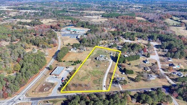
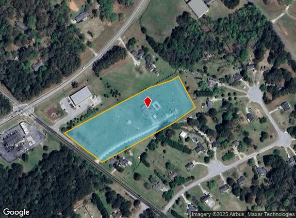
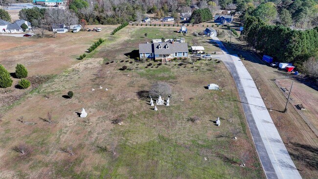
This Property Is For Sale
NEARBY LISTINGS FOR SALE OR LEASE
Property Detail
3615 Miller Bottom Rd
Atlanta-Sandy Springs-Roswell, GA
1-A & Tr 1-B
C002000000026000
Walton
Sfr
Georgia
X
5.25 AC
13247C0040D
Walton County
2,218 SF
Atlanta
DEMOGRAPHICS near 3615 Miller Bottom Rd
1 Mile
3 Mile
5 Mile
2024 Total Population
1,349
18,747
72,159
2029 Population
1,528
20,095
76,693
Pop Growth 2024-2029
+ 13.27%
+ 7.19%
+ 6.28%
Average Age
40
39
39
2024 Total Households
443
6,005
23,287
HH Growth 2024-2029
+ 13.54%
+ 7.48%
+ 6.44%
Median Household Inc
$103,236
$94,297
$86,533
Avg Household Size
2.90
3.10
3.00
2024 Avg HH Vehicles
3.00
2.00
2.00
Median Home Value
$250,662
$264,764
$262,541
Median Year Built
2000
2000
1997
Nearby Places
- Restaurants
- Banks
- Shops
- Fitness
- Groceries
PUBLIC TRANSPORTATION
AIRPORT
Hartsfield - Jackson Atlanta International
DRIVE
WALK
Distance
Hartsfield - Jackson Atlanta International
52 min
34.4 mi
Freight Ports
Georgia Ports - Savannah
DRIVE
WALK
Distance
Georgia Ports - Savannah
296 min
249.6 mi
Nearby Properties
Address
Land Use
TOTAL SIZE
Lot Size
Zoning
Address
Land Use
TOTAL SIZE
Lot Size
Zoning
162,474 SF
41 AC
R100
Address
Land Use
TOTAL SIZE
Lot Size
Zoning
23,692 SF
112.46 AC
RA200
Address
Land Use
TOTAL SIZE
Lot Size
Zoning
96,107 SF
79.63 AC
A2
Address
Land Use
TOTAL SIZE
Lot Size
Zoning
1,296 SF
65.93 AC
R100
Address
Land Use
TOTAL SIZE
Lot Size
Zoning
42,183 SF
11.87 AC
C2
Address
Land Use
TOTAL SIZE
Lot Size
Zoning
20,812 SF
16.29 AC
R100
Address
Land Use
TOTAL SIZE
Lot Size
Zoning
653.65 AC
WP
Address
Land Use
TOTAL SIZE
Lot Size
Zoning
11,580 SF
11.38 AC
B2
Address
Land Use
TOTAL SIZE
Lot Size
Zoning
14,487 SF
9.69 AC
R100
Address
Land Use
TOTAL SIZE
Lot Size
Zoning
2,400 SF
10.77 AC
R100
Address
Land Use
TOTAL SIZE
Lot Size
Zoning
7,664 SF
1.32 AC
C1
Address
Land Use
TOTAL SIZE
Lot Size
Zoning
8,052 SF
9.44 AC
R100
Address
Land Use
TOTAL SIZE
Lot Size
Zoning
35,000 SF
8.27 AC
M1
Address
Land Use
TOTAL SIZE
Lot Size
Zoning
3,800 SF
1.70 AC
C2
Address
Land Use
TOTAL SIZE
Lot Size
Zoning
6,000 SF
53.59 AC
A2 B3
Address
Land Use
TOTAL SIZE
Lot Size
Zoning
2,856 SF
14.36 AC
A1
Address
Land Use
TOTAL SIZE
Lot Size
Zoning
2,072 SF
15.86 AC
A1 MH
Address
Land Use
TOTAL SIZE
Lot Size
Zoning
2,790 SF
51.37 AC
R100
Address
Land Use
TOTAL SIZE
Lot Size
Zoning
16,994 SF
18.85 AC
B2 B3
Address
Land Use
TOTAL SIZE
Lot Size
Zoning
1,216 SF
209.58 AC
A1
Address
Land Use
TOTAL SIZE
Lot Size
Zoning
2,160 SF
7.09 AC
R100
Address
Land Use
TOTAL SIZE
Lot Size
Zoning
127 AC
R1OSC
Address
Land Use
TOTAL SIZE
Lot Size
Zoning
9,000 SF
21 AC
AR/WP
Address
Land Use
TOTAL SIZE
Lot Size
Zoning
19,500 SF
2.03 AC
B2
Address
Land Use
TOTAL SIZE
Lot Size
Zoning
550 SF
51.57 AC
B3
Address
Land Use
TOTAL SIZE
Lot Size
Zoning
6,099 SF
2.04 AC
C2
Address
Land Use
TOTAL SIZE
Lot Size
Zoning
1,824 SF
166.24 AC
A1
Address
Land Use
TOTAL SIZE
Lot Size
Zoning
3,500 SF
13.41 AC
A2
Address
Land Use
TOTAL SIZE
Lot Size
Zoning
57.21 AC
R100
Address
Land Use
TOTAL SIZE
Lot Size
Zoning
62.06 AC
R100
The World's #1 Commercial Real Estate Marketplace
Connect with us
© 2025 CoStar Group
The information above has been obtained from sources believed reliable. While we do not doubt its accuracy we have not verified it and make no guarantee, warranty or representation about it. It is your responsibility to independently confirm its accuracy and completeness. Any projections, opinions, assumptions, or estimates used are for example only and do not represent the current or future performance of the property. The value of this transaction to you depends on tax and other factors which should be evaluated by your tax, financial, and legal advisors. You and your advisors should conduct a careful, independent investigation of the property to determine to your satisfaction the suitability of the property for your needs.