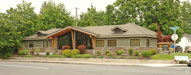
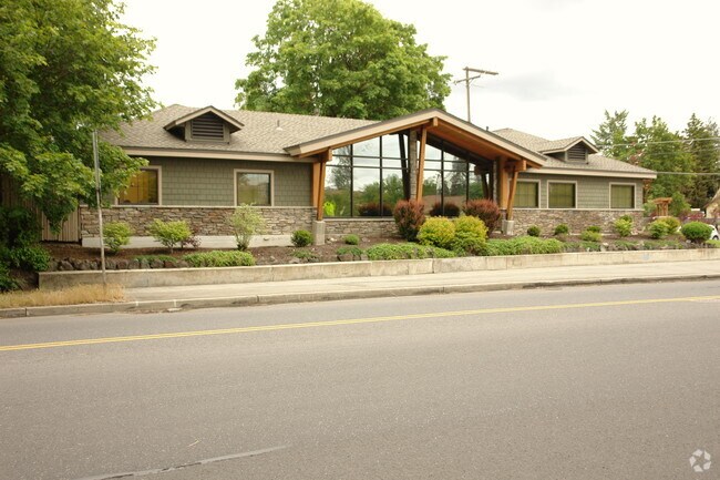
Property Record
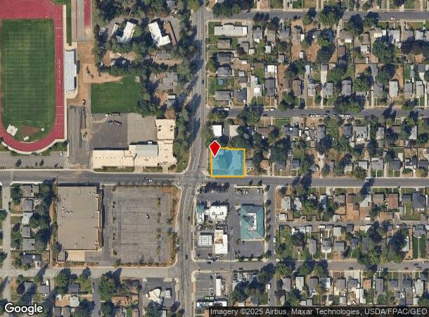
3615 S Grand Blvd, Spokane, WA 99203

NEARBY LISTINGS FOR SALE OR LEASE
Property Detail
3615 S Grand Blvd
Spokane-Spokane Valley, WA
Acre Park Add
35322.3012
ACRE PARK ADD W70 OF LT 22 EXC N97 & E54 OF W124 O F S1/2 OF LT 22 BLK 60
Commercialnec
Spokane
X
Washington
53063C0707D
22
2025
0.29 AC
2025
South Hill
004400
Spokane
2,654 SF
DEMOGRAPHICS near 3615 S Grand Blvd
1 Mile
3 Mile
5 Mile
2024 Total Population
12,266
88,665
165,282
2029 Population
13,059
94,635
176,324
Pop Growth 2024-2029
+ 6.47%
+ 6.73%
+ 6.68%
Average Age
43
41
40
2024 Total Households
5,264
38,901
69,861
HH Growth 2024-2029
+ 6.71%
+ 7.09%
+ 7.02%
Median Household Inc
$83,539
$67,619
$61,117
Avg Household Size
2.30
2.20
2.20
2024 Avg HH Vehicles
2.00
2.00
2.00
Median Home Value
$454,664
$409,723
$363,855
Median Year Built
1954
1973
1970
Nearby Places
Map Layers
Map Styles
 Street
 Aerial
- Restaurants
- Banks
- Shops
- Fitness
- Groceries
PUBLIC TRANSPORTATION
COMMUTER RAIL
DRIVE
WALK
Distance
9 min
2.9 mi
AIRPORT
Spokane International
DRIVE
WALK
Distance
Spokane International
18 min
8.9 mi
Nearby Properties
Address
Land Use
TOTAL SIZE
Lot Size
Zoning
Address
Land Use
TOTAL SIZE
Lot Size
Zoning
763,627 SF
12.44 AC
OR
Address
Land Use
TOTAL SIZE
Lot Size
Zoning
481,348 SF
17.09 AC
DTU
Address
Land Use
TOTAL SIZE
Lot Size
Zoning
536,438 SF
1.70 AC
DTC
Address
Land Use
TOTAL SIZE
Lot Size
Zoning
226,702 SF
49.25 AC
RSF
Address
Land Use
TOTAL SIZE
Lot Size
Zoning
365,804 SF
16.13 AC
RSF
Address
Land Use
TOTAL SIZE
Lot Size
Zoning
251,542 SF
5.78 AC
DTG
Address
Land Use
TOTAL SIZE
Lot Size
Zoning
270,262 SF
29.10 AC
Address
Land Use
TOTAL SIZE
Lot Size
Zoning
218,684 SF
13.29 AC
RMF
Address
Land Use
TOTAL SIZE
Lot Size
Zoning
91,882 SF
2.07 AC
OR
Address
Land Use
TOTAL SIZE
Lot Size
Zoning
124,234 SF
13.54 AC
RSF
Address
Land Use
TOTAL SIZE
Lot Size
Zoning
210,277 SF
19.18 AC
RMF
Address
Land Use
TOTAL SIZE
Lot Size
Zoning
314,149 SF
1.07 AC
DTC
Address
Land Use
TOTAL SIZE
Lot Size
Zoning
151,667 SF
7.45 AC
DTG
Address
Land Use
TOTAL SIZE
Lot Size
Zoning
289,705 SF
3.36 AC
OR
Address
Land Use
TOTAL SIZE
Lot Size
Zoning
50,869 SF
0.61 AC
DTC
Address
Land Use
TOTAL SIZE
Lot Size
Zoning
137,503 SF
17.31 AC
GC
Address
Land Use
TOTAL SIZE
Lot Size
Zoning
182,088 SF
0.37 AC
DTC
Address
Land Use
TOTAL SIZE
Lot Size
Zoning
107,240 SF
1.54 AC
CC1
Address
Land Use
TOTAL SIZE
Lot Size
Zoning
53,748 SF
1.26 AC
DTC
Address
Land Use
TOTAL SIZE
Lot Size
Zoning
289,573 SF
7.73 AC
RMF
Address
Land Use
TOTAL SIZE
Lot Size
Zoning
259,221 SF
5.06 AC
DTC
Address
Land Use
TOTAL SIZE
Lot Size
Zoning
135,715 SF
4.73 AC
RMF
Address
Land Use
TOTAL SIZE
Lot Size
Zoning
91,048 SF
3.81 AC
OR
Address
Land Use
TOTAL SIZE
Lot Size
Zoning
16,384 SF
1.21 AC
DTC
Address
Land Use
TOTAL SIZE
Lot Size
Zoning
119,933 SF
5.61 AC
Address
Land Use
TOTAL SIZE
Lot Size
Zoning
127,826 SF
0.33 AC
DTG
Address
Land Use
TOTAL SIZE
Lot Size
Zoning
138,840 SF
2.79 AC
DTU
Address
Land Use
TOTAL SIZE
Lot Size
Zoning
159,720 SF
6.84 AC
RMF
Address
Land Use
TOTAL SIZE
Lot Size
Zoning
30,250 SF
1.05 AC
DTC
Address
Land Use
TOTAL SIZE
Lot Size
Zoning
66,193 SF
1.99 AC
OR
The World's #1 Commercial Real Estate Marketplace
Connect with us
© 2025 CoStar Group
The information above has been obtained from sources believed reliable. While we do not doubt its accuracy we have not verified it and make no guarantee, warranty or representation about it. It is your responsibility to independently confirm its accuracy and completeness. Any projections, opinions, assumptions, or estimates used are for example only and do not represent the current or future performance of the property. The value of this transaction to you depends on tax and other factors which should be evaluated by your tax, financial, and legal advisors. You and your advisors should conduct a careful, independent investigation of the property to determine to your satisfaction the suitability of the property for your needs.