Property Record
3616 S B St, Stockton, CA 95206
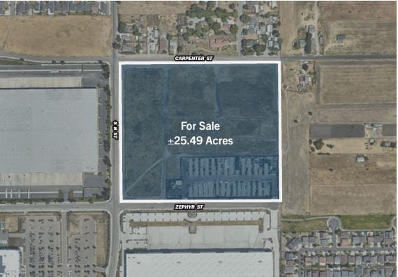
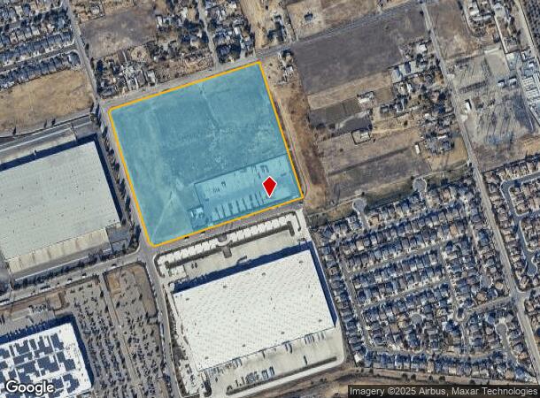
This Property Is For Sale
NEARBY LISTINGS FOR SALE OR LEASE
Property Detail
3616 S B St
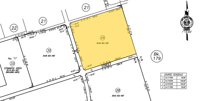
177-140-26
Airport Way Condo
Industrialacreage
05-FM PT OF 08/PT TO 25/27/28/RD 05028996/PM22-145
X
San Joaquin
06077C0490F
California
2025
25.49 AC
2025
Stockton
002401
Stockton/Modesto
1,428 SF
Stockton-Lodi, CA
DEMOGRAPHICS near 3616 S B St
1 Mile
3 Mile
5 Mile
2024 Total Population
9,970
73,716
163,152
2029 Population
10,555
77,469
171,677
Pop Growth 2024-2029
+ 5.87%
+ 5.09%
+ 5.23%
Average Age
33
34
35
2024 Total Households
2,491
18,934
45,343
HH Growth 2024-2029
+ 5.90%
+ 5.22%
+ 5.44%
Median Household Inc
$53,879
$49,660
$55,073
Avg Household Size
3.80
3.60
3.30
2024 Avg HH Vehicles
2.00
2.00
2.00
Median Home Value
$316,885
$284,854
$325,187
Median Year Built
1999
1969
1968
Nearby Places
- Restaurants
- Banks
- Shops
- Fitness
- Groceries
PUBLIC TRANSPORTATION
COMMUTER RAIL
Stockton (ACE Train - Altamont Commuter Express (ACE), Altamont Corridor Express - Altamont Commuter Express (ACE))
DRIVE
WALK
Distance
Stockton (ACE Train - Altamont Commuter Express (ACE), Altamont Corridor Express - Altamont Commuter Express (ACE))
9 min
4.2 mi
Stockton (San Joaquins - Amtrak)
DRIVE
WALK
Distance
Stockton (San Joaquins - Amtrak)
9 min
4.2 mi
AIRPORT
Stockton Metro
DRIVE
WALK
Distance
Stockton Metro
7 min
2.8 mi
Freight Ports
Port of Stockton
DRIVE
WALK
Distance
Port of Stockton
14 min
7.4 mi
Nearby Properties
Address
Land Use
TOTAL SIZE
Lot Size
Zoning
Address
Land Use
TOTAL SIZE
Lot Size
Zoning
57.72 AC
Address
Land Use
TOTAL SIZE
Lot Size
Zoning
1,122,341 SF
61.64 AC
IL
Address
Land Use
TOTAL SIZE
Lot Size
Zoning
67.72 AC
Address
Land Use
TOTAL SIZE
Lot Size
Zoning
240,210 SF
66.15 AC
Address
Land Use
TOTAL SIZE
Lot Size
Zoning
615,440 SF
76.23 AC
IG
Address
Land Use
TOTAL SIZE
Lot Size
Zoning
39.06 AC
Address
Land Use
TOTAL SIZE
Lot Size
Zoning
749,983 SF
52.76 AC
Address
Land Use
TOTAL SIZE
Lot Size
Zoning
35.97 AC
IL
Address
Land Use
TOTAL SIZE
Lot Size
Zoning
780,371 SF
46.04 AC
IG
Address
Land Use
TOTAL SIZE
Lot Size
Zoning
824,735 SF
52.87 AC
Address
Land Use
TOTAL SIZE
Lot Size
Zoning
326,934 SF
56.52 AC
IG
Address
Land Use
TOTAL SIZE
Lot Size
Zoning
545,832 SF
29.07 AC
Address
Land Use
TOTAL SIZE
Lot Size
Zoning
502,000 SF
19.76 AC
Address
Land Use
TOTAL SIZE
Lot Size
Zoning
574,560 SF
32.34 AC
Address
Land Use
TOTAL SIZE
Lot Size
Zoning
419,608 SF
23.01 AC
IG
Address
Land Use
TOTAL SIZE
Lot Size
Zoning
511,718 SF
21.18 AC
Address
Land Use
TOTAL SIZE
Lot Size
Zoning
506,844 SF
26.99 AC
Address
Land Use
TOTAL SIZE
Lot Size
Zoning
285,480 SF
15.70 AC
IL
Address
Land Use
TOTAL SIZE
Lot Size
Zoning
508,800 SF
24 AC
Address
Land Use
TOTAL SIZE
Lot Size
Zoning
735,980 SF
39.42 AC
Address
Land Use
TOTAL SIZE
Lot Size
Zoning
434,900 SF
17.05 AC
Address
Land Use
TOTAL SIZE
Lot Size
Zoning
512,000 SF
20.16 AC
Address
Land Use
TOTAL SIZE
Lot Size
Zoning
521,500 SF
12.06 AC
Address
Land Use
TOTAL SIZE
Lot Size
Zoning
513,778 SF
11.88 AC
Address
Land Use
TOTAL SIZE
Lot Size
Zoning
69,954 SF
24.92 AC
Address
Land Use
TOTAL SIZE
Lot Size
Zoning
388,183 SF
18.90 AC
Address
Land Use
TOTAL SIZE
Lot Size
Zoning
586,610 SF
27.36 AC
Address
Land Use
TOTAL SIZE
Lot Size
Zoning
522,400 SF
23.72 AC
The World's #1 Commercial Real Estate Marketplace
Connect with us
© 2025 CoStar Group
The information above has been obtained from sources believed reliable. While we do not doubt its accuracy we have not verified it and make no guarantee, warranty or representation about it. It is your responsibility to independently confirm its accuracy and completeness. Any projections, opinions, assumptions, or estimates used are for example only and do not represent the current or future performance of the property. The value of this transaction to you depends on tax and other factors which should be evaluated by your tax, financial, and legal advisors. You and your advisors should conduct a careful, independent investigation of the property to determine to your satisfaction the suitability of the property for your needs.