Property Record
36169 Marshall Hutts Rd, Rio Hondo, TX 78583


NEARBY LISTINGS FOR SALE OR LEASE
-
-
View all Rio Hondo listings for sale on LoopNet.com
Property Detail
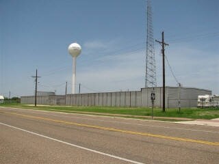
36169 Marshall Hutts Rd
Brownsville-Harlingen, TX
Espiritu Santo Grant Share 19
791900-0500-240000
ABST2 - UNSUBDIVIDED SH 19 TR 50 A RR FRT-2 LOTS AN-40 TO AN-43 (CH ANNEL VIEW RV PK)
Commercialnec
Cameron
AE
Texas
48061C0175F
an-40
2024
0.87 AC
2025
Outlying Cameron County
010102
Brownsville/Harlingen
192 SF
DEMOGRAPHICS near 36169 Marshall Hutts Rd
1 Mile
3 Mile
5 Mile
2024 Total Population
397
881
1,036
2029 Population
444
969
1,128
Pop Growth 2024-2029
+ 11.84%
+ 9.99%
+ 8.88%
Average Age
42
44
46
2024 Total Households
134
323
400
HH Growth 2024-2029
+ 11.19%
+ 9.29%
+ 7.75%
Median Household Inc
$13,630
$14,431
$22,500
Avg Household Size
2.40
2.30
2.30
2024 Avg HH Vehicles
2.00
2.00
2.00
Median Home Value
$163,923
$173,053
$178,947
Median Year Built
1989
1991
1993
Nearby Places
Map Layers
Map Styles
 Street
 Aerial
- Restaurants
- Banks
- Shops
- Fitness
- Groceries
PUBLIC TRANSPORTATION
AIRPORT
Valley International
DRIVE
WALK
Distance
Valley International
50 min
24.4 mi
Brownsville/South Padre Island International
DRIVE
WALK
Distance
Brownsville/South Padre Island International
58 min
32.6 mi
Freight Ports
Port of Brownsville
DRIVE
WALK
Distance
Port of Brownsville
51 min
28.8 mi
Nearby Properties
Address
Land Use
TOTAL SIZE
Lot Size
Zoning
Address
Land Use
TOTAL SIZE
Lot Size
Zoning
20,530 SF
1,880.28 AC
Address
Land Use
TOTAL SIZE
Lot Size
Zoning
498.67 AC
Address
Land Use
TOTAL SIZE
Lot Size
Zoning
4,129 SF
3.83 AC
A-R
Address
Land Use
TOTAL SIZE
Lot Size
Zoning
7,981 SF
1.06 AC
A-R
Address
Land Use
TOTAL SIZE
Lot Size
Zoning
18,000 SF
10.99 AC
Address
Land Use
TOTAL SIZE
Lot Size
Zoning
6,112 SF
0.78 AC
Address
Land Use
TOTAL SIZE
Lot Size
Zoning
15,723 SF
0.97 AC
Address
Land Use
TOTAL SIZE
Lot Size
Zoning
432 SF
1.47 AC
Address
Land Use
TOTAL SIZE
Lot Size
Zoning
3,154 SF
0.61 AC
Address
Land Use
TOTAL SIZE
Lot Size
Zoning
12,960 SF
0.98 AC
C
Address
Land Use
TOTAL SIZE
Lot Size
Zoning
17,400 SF
1.25 AC
Address
Land Use
TOTAL SIZE
Lot Size
Zoning
13,068 SF
0.87 AC
Address
Land Use
TOTAL SIZE
Lot Size
Zoning
2,646 SF
0.67 AC
Address
Land Use
TOTAL SIZE
Lot Size
Zoning
5,580 SF
0.59 AC
Address
Land Use
TOTAL SIZE
Lot Size
Zoning
160 SF
4.25 AC
A-U
Address
Land Use
TOTAL SIZE
Lot Size
Zoning
10,000 SF
1.66 AC
Address
Land Use
TOTAL SIZE
Lot Size
Zoning
3,432 SF
0.41 AC
Address
Land Use
TOTAL SIZE
Lot Size
Zoning
3,415 SF
0.92 AC
Address
Land Use
TOTAL SIZE
Lot Size
Zoning
3,050 SF
0.25 AC
Address
Land Use
TOTAL SIZE
Lot Size
Zoning
3,801 SF
0.60 AC
Address
Land Use
TOTAL SIZE
Lot Size
Zoning
400 SF
2.62 AC
Address
Land Use
TOTAL SIZE
Lot Size
Zoning
6,837 SF
2.72 AC
Address
Land Use
TOTAL SIZE
Lot Size
Zoning
0.92 AC
Address
Land Use
TOTAL SIZE
Lot Size
Zoning
3,982 SF
0.28 AC
A-R
Address
Land Use
TOTAL SIZE
Lot Size
Zoning
5,000 SF
0.23 AC
Address
Land Use
TOTAL SIZE
Lot Size
Zoning
3,806 SF
0.65 AC
Address
Land Use
TOTAL SIZE
Lot Size
Zoning
1.71 AC
Address
Land Use
TOTAL SIZE
Lot Size
Zoning
2,812 SF
0.26 AC
The World's #1 Commercial Real Estate Marketplace
Connect with us
© 2026 CoStar Group
The information above has been obtained from sources believed reliable. While we do not doubt its accuracy we have not verified it and make no guarantee, warranty or representation about it. It is your responsibility to independently confirm its accuracy and completeness. Any projections, opinions, assumptions, or estimates used are for example only and do not represent the current or future performance of the property. The value of this transaction to you depends on tax and other factors which should be evaluated by your tax, financial, and legal advisors. You and your advisors should conduct a careful, independent investigation of the property to determine to your satisfaction the suitability of the property for your needs.