Property Record
3617 Macon Rd, Columbus, GA 31907


Save to a Folder
{{folder.Name}}
{{folder.ListingIds.length}} Properties
{{folder.ListingIds.length}} Property
Create a New Folder
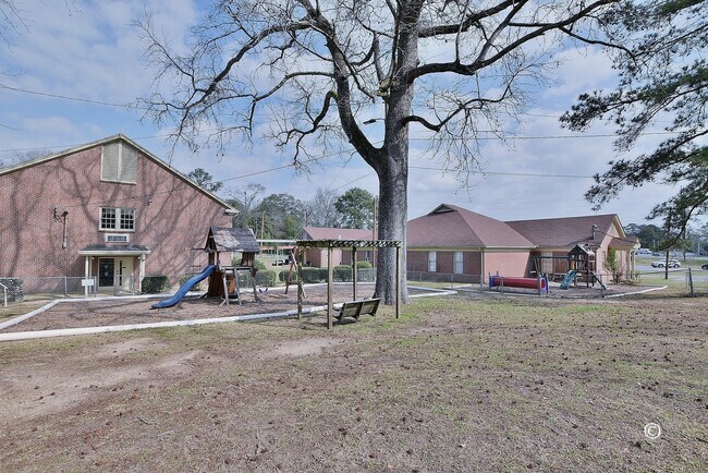
Property Detail
3617 Macon Rd
Columbus, GA-AL
LT 110 REPLAT 11-F MAGNOLIA HILL & ADJACENT LAND NT
068-043-012
Muscogee
Religious
Georgia
B and X Area of moderate flood hazard, usually the area between the limits of the 100-year and 500-year floods.
110
0
5.54 AC
2025
Greater Columbus
001000
Columbus GA
NEARBY LISTINGS FOR SALE OR LEASE
DEMOGRAPHICS near 3617 Macon Rd
1 mile
3 mile
5 mile
2025 Total Population
6,816
73,579
153,197
2030 Population
6,544
71,460
149,264
Pop Growth 2025-2030
(3.99%)
(2.88%)
(2.57%)
Average Age
37
39
39
2025 Total Households
2,488
30,457
64,368
HH Growth 2025-2030
(4.14%)
(2.61%)
(2.25%)
Median Household Inc
$61,590
$43,870
$45,861
Avg Household Size
2.40
2.30
2.30
2025 Avg HH Vehicles
2.00
2.00
2.00
Median Home Value
$197,254
$163,587
$172,974
Median Year Built
1965
1968
1973
Nearby Places
Map Layers
Map Styles
 Street
 Aerial
Layers
 Traffic
 Biking
Places
Listings with unknown addresses are not visible on the map
- Restaurants
- Banks
- Shops
- Fitness
- Groceries
PUBLIC TRANSPORTATION
AIRPORT
Columbus
Drive
Walk
Distance
Columbus
7 min
4.2 mi
Freight Ports
Port of Panama City
Drive
Walk
Distance
Port of Panama City
237 min
187.3 mi
SALE & LEASE HISTORY
LISTING DATE
SALE/LEASE

Feb 26, 2023
For Sale
Nearby Properties
Address
Land Use
TOTAL SIZE
Lot Size
Zoning
Address
Land Use
TOTAL SIZE
Lot Size
Zoning
81,423 SF
11.54 AC
Address
Land Use
TOTAL SIZE
Lot Size
Zoning
174,892 SF
19.03 AC
Address
Land Use
TOTAL SIZE
Lot Size
Zoning
55,900 SF
27.05 AC
Address
Land Use
TOTAL SIZE
Lot Size
Zoning
210,532 SF
57.21 AC
Address
Land Use
TOTAL SIZE
Lot Size
Zoning
14,253 SF
6.71 AC
Address
Land Use
TOTAL SIZE
Lot Size
Zoning
37,202 SF
8.03 AC
Address
Land Use
TOTAL SIZE
Lot Size
Zoning
10,683 SF
588.24 AC
Address
Land Use
TOTAL SIZE
Lot Size
Zoning
56,095 SF
25.91 AC
Address
Land Use
TOTAL SIZE
Lot Size
Zoning
4,360 SF
25.18 AC
Address
Land Use
TOTAL SIZE
Lot Size
Zoning
27,621 SF
6.33 AC
Address
Land Use
TOTAL SIZE
Lot Size
Zoning
32,238 SF
7.21 AC
Address
Land Use
TOTAL SIZE
Lot Size
Zoning
360 SF
106.65 AC
Address
Land Use
TOTAL SIZE
Lot Size
Zoning
4,187 SF
12.56 AC
Address
Land Use
TOTAL SIZE
Lot Size
Zoning
6,254 SF
13.04 AC
Address
Land Use
TOTAL SIZE
Lot Size
Zoning
142,703 SF
28.48 AC
Address
Land Use
TOTAL SIZE
Lot Size
Zoning
45,932 SF
29 AC
Address
Land Use
TOTAL SIZE
Lot Size
Zoning
150,424 SF
22.95 AC
Address
Land Use
TOTAL SIZE
Lot Size
Zoning
78,948 SF
6 AC
Address
Land Use
TOTAL SIZE
Lot Size
Zoning
25,379 SF
4.89 AC
Address
Land Use
TOTAL SIZE
Lot Size
Zoning
140,739 SF
32.87 AC
Address
Land Use
TOTAL SIZE
Lot Size
Zoning
72,200 SF
5.52 AC
Address
Land Use
TOTAL SIZE
Lot Size
Zoning
2,870 SF
8.75 AC
Address
Land Use
TOTAL SIZE
Lot Size
Zoning
Address
Land Use
TOTAL SIZE
Lot Size
Zoning
68,035 SF
19.90 AC
Address
Land Use
TOTAL SIZE
Lot Size
Zoning
48,100 SF
9 AC
Address
Land Use
TOTAL SIZE
Lot Size
Zoning
7,860 SF
134.92 AC
Address
Land Use
TOTAL SIZE
Lot Size
Zoning
5,414 SF
17.11 AC
Address
Land Use
TOTAL SIZE
Lot Size
Zoning
271,364 SF
71.66 AC
Address
Land Use
TOTAL SIZE
Lot Size
Zoning
5,514 SF
15.28 AC
Address
Land Use
TOTAL SIZE
Lot Size
Zoning
32,202 SF
8.42 AC
The World's #1 Commercial Real Estate Marketplace
Connect with us
© 2026 CoStar Group
The information above has been obtained from sources believed reliable. While we do not doubt its accuracy we have not verified it and make no guarantee, warranty or representation about it. It is your responsibility to independently confirm its accuracy and completeness. Any projections, opinions, assumptions, or estimates used are for example only and do not represent the current or future performance of the property. The value of this transaction to you depends on tax and other factors which should be evaluated by your tax, financial, and legal advisors. You and your advisors should conduct a careful, independent investigation of the property to determine to your satisfaction the suitability of the property for your needs.