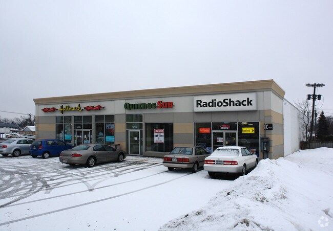
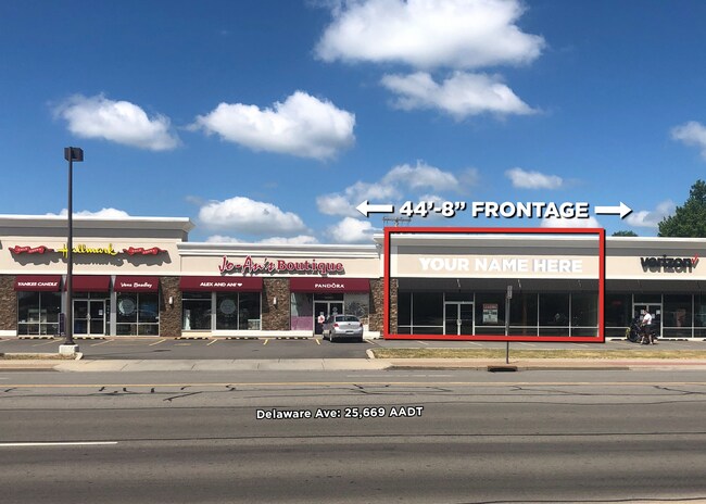
Property Record
3618 Delaware Ave, Buffalo, NY 14217
NEARBY LISTINGS FOR SALE OR LEASE
Property Detail
3618 Delaware Ave
146489-066-300-0001-019-000
COR S COLONIAL AVE 1306 87 TO 90 INCL 128.6 X 112.51
Storesoffices
Erie
X
New York
36029C0205H
19.000
2025
0.34 AC
2024
North
008201
Buffalo/Niagara Falls
4,300 SF
Buffalo-Cheektowaga-Niagara Falls, NY
DEMOGRAPHICS near 3618 Delaware Ave
1 Mile
3 Mile
5 Mile
2024 Total Population
16,720
129,564
296,275
2029 Population
16,537
127,404
291,470
Pop Growth 2024-2029
(1.09%)
(1.67%)
(1.62%)
Average Age
43
41
39
2024 Total Households
7,733
58,916
126,100
HH Growth 2024-2029
(1.23%)
(1.71%)
(1.69%)
Median Household Inc
$62,772
$60,467
$57,974
Avg Household Size
2.10
2.10
2.20
2024 Avg HH Vehicles
1.00
1.00
1.00
Median Home Value
$165,036
$165,878
$175,120
Median Year Built
1951
1950
1949
Nearby Places
- Restaurants
- Banks
- Shops
- Fitness
- Groceries
PUBLIC TRANSPORTATION
AIRPORT
Buffalo Niagara International
DRIVE
WALK
Distance
Buffalo Niagara International
19 min
9.2 mi
Niagara Falls International
DRIVE
WALK
Distance
Niagara Falls International
20 min
10.1 mi
SALE & LEASE HISTORY
LISTING DATE
SALE/LEASE

Jul 11, 2018
For Lease
Nearby Properties
Address
Land Use
TOTAL SIZE
Lot Size
Zoning
Address
Land Use
TOTAL SIZE
Lot Size
Zoning
139,224 SF
13.72 AC
WID
Address
Land Use
TOTAL SIZE
Lot Size
Zoning
239,735 SF
17.73 AC
TND
Address
Land Use
TOTAL SIZE
Lot Size
Zoning
70,261 SF
14.63 AC
CTR-5
Address
Land Use
TOTAL SIZE
Lot Size
Zoning
100,737 SF
21.10 AC
CTR-5
Address
Land Use
TOTAL SIZE
Lot Size
Zoning
117,980 SF
14.40 AC
CTR-5
Address
Land Use
TOTAL SIZE
Lot Size
Zoning
197,430 SF
8.20 AC
Address
Land Use
TOTAL SIZE
Lot Size
Zoning
197,430 SF
7.35 AC
Address
Land Use
TOTAL SIZE
Lot Size
Zoning
3,456 SF
6.90 AC
MFR-5
Address
Land Use
TOTAL SIZE
Lot Size
Zoning
122,669 SF
7.94 AC
CTR-2.5
Address
Land Use
TOTAL SIZE
Lot Size
Zoning
109,461 SF
7.90 AC
CTR-5
Address
Land Use
TOTAL SIZE
Lot Size
Zoning
113,316 SF
12.25 AC
CTR-5
Address
Land Use
TOTAL SIZE
Lot Size
Zoning
650,000 SF
42.15 AC
G-1
Address
Land Use
TOTAL SIZE
Lot Size
Zoning
3,200 SF
4.96 AC
SC-3
Address
Land Use
TOTAL SIZE
Lot Size
Zoning
67,666 SF
17.43 AC
G-1
Address
Land Use
TOTAL SIZE
Lot Size
Zoning
3.20 AC
G-1
Address
Land Use
TOTAL SIZE
Lot Size
Zoning
11,808 SF
11.93 AC
N-3R
Address
Land Use
TOTAL SIZE
Lot Size
Zoning
2,474 SF
24.84 AC
Address
Land Use
TOTAL SIZE
Lot Size
Zoning
67,000 SF
6.50 AC
Address
Land Use
TOTAL SIZE
Lot Size
Zoning
120,954 SF
9.74 AC
D-S
Address
Land Use
TOTAL SIZE
Lot Size
Zoning
99,488 SF
3.20 AC
Address
Land Use
TOTAL SIZE
Lot Size
Zoning
384,825 SF
39.95 AC
CTR-2.5
Address
Land Use
TOTAL SIZE
Lot Size
Zoning
6,862 SF
14.28 AC
CTR-5
Address
Land Use
TOTAL SIZE
Lot Size
Zoning
356,891 SF
21.33 AC
B
Address
Land Use
TOTAL SIZE
Lot Size
Zoning
16 AC
G-1
Address
Land Use
TOTAL SIZE
Lot Size
Zoning
90,888 SF
9.13 AC
CTR-2.5
Address
Land Use
TOTAL SIZE
Lot Size
Zoning
151,641 SF
1.53 AC
N-1S
Address
Land Use
TOTAL SIZE
Lot Size
Zoning
107,490 SF
3.55 AC
Address
Land Use
TOTAL SIZE
Lot Size
Zoning
81,224 SF
0.45 AC
Address
Land Use
TOTAL SIZE
Lot Size
Zoning
33,970 SF
9.70 AC
Address
Land Use
TOTAL SIZE
Lot Size
Zoning
72,030 SF
2.70 AC
CTR-5
The World's #1 Commercial Real Estate Marketplace
Connect with us
© 2025 CoStar Group
The information above has been obtained from sources believed reliable. While we do not doubt its accuracy we have not verified it and make no guarantee, warranty or representation about it. It is your responsibility to independently confirm its accuracy and completeness. Any projections, opinions, assumptions, or estimates used are for example only and do not represent the current or future performance of the property. The value of this transaction to you depends on tax and other factors which should be evaluated by your tax, financial, and legal advisors. You and your advisors should conduct a careful, independent investigation of the property to determine to your satisfaction the suitability of the property for your needs.